Menu

Ireland's sailing, boating & maritime magazine

Dublin Bay Boating News and Information

Displaying items by tag: Isle of Skye

An exclusion zone was set up around a cargo ship out of Drogheda that ran aground in Scotland’s Hebrides earlier this week, as it was battered by persisting storm conditions.

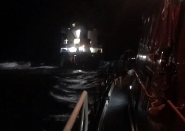
As previously reported on Afloat.ie, eight crew were airlifted from the MV Kaami on Monday (23 March) after it grounded on a reef known locally as Eugenie Rock, some six nautical miles off the Isle of Skye.

The MV Kaami had left Drogheda Port less than two days previously, en route for Slite in Sweden, with a cargo of refuse-derives fuel (RDF) in pellet form.

The Press and Journal reports that a salvage team arrived on Tuesday (24 March) to inspect the abandoned vessel, while the tug Ievoli Black remained at the scene on guard.

Published in Ports & Shipping

Eight crew were rescued from a cargo ship out of Drogheda that ran aground off the Isle of Skye in Scotland’s Inner Hebrides early yesterday morning (Monday 23 March).

The MV Kaami had left Drogheda Port on the evening of Saturday 21 March and was due to arrive in Slite, Sweden this weekend.

But the 90m cargo vessel ran aground in The Minch at what’s known locally as Eugenie Rock, about six nautical miles north-west of Duntulm on Skye.

Portree RNLI’s lifeboat was launched at 2.24am yesterday morning in response to a MayDay call from the MV Kaami, as did the Emergency Towing Vessel Ievoli Black and the Pharos, a Northern Lighthouse Board buoy-laying vessel.

The duty Stornoway Coastguard rescue helicopter arrived on scene, where weather conditions has a Force 8 southerly wind with a rough sea state, and began to airlift eight of the Russian crew to Stornoway. No injuries were reported.

Published in Rescue
An Irish cargo-vessel, Red Duchess got into difficulties when the ship broke down off the Isle of Rhum on Tuesday, writes Jehan Ashmore.

The 1,285grt coaster owned by Coast Lines, was bound for Stornoway with a cargo of coal when the incident occurred. Onboard the vessel was 27 cubic metres of diesel oil and 400 litres of lube oil.

Despite the lack of engine-power, the vessel maintained electricity capacity but was unable to use anchor while drifting in 20m waters and over a rocky seabed. The vessel continued to drift in Force 7-8 conditions, close to the islands in Harris Bay. Fortunately the Mallaig lifeboat was able to get a line onboard the 1969 built Red Duchess to halt further drifting closer to the shore.

This brought some extra time for the stricken vessel until the UK Maritime & Coastguard Safety Agency (MCA) deployed their ETV (Emergency Towing Vessel) Anglian Prince (1980/1,641grt) to the scene.

In the interim period a coastguard rescue helicopter moved to Rhum to be on standby in the event of having to evacuate the crew. This was not required as the Anglian Prince managed to secure a line and safely tow the Red Duchess to Stornoway.

The Red Duchess is a veteren vessel in the coastal trade, regularly trading throughout Irish Sea ports and in particular for many years has been engaged in the carriage of timber logs between Scotland and Youghal, Co. Waterford.

As for the ETV Anglian Princess, she was involved only a fortnight ago in the high-profile rescue of the Royal Navy's HMS Astute, described as the newest, largest and stealthiest attack class submarine. The £1.2 billion submarine was believed to be undergoing sea trials when it went aground off the Isle of Skye. Anglian Princess successfully pulled free the submarine from a shingle bank.

Ironically hours before the the submarine's grounding, the Anglian Princess and three other ETV vessels were announced by the British Government to be withdrawn funding from the nation's (ETV) Emergency Towing Vessel service. The charter of the fleet of four ETV's from owners Klyne Tugs (Lowestoft) Ltd to the UK's Maritime & Coastguard Safety Agency (MCA) was expected to last with the current contract expiring in September 2011.

Since 2001, KTL's fleet of powerful tugs are on charter to the (MCA) for use in pollution control incidents and for towing vessels which are in difficulty in coastal waters.

The fleet are based in strategic locations around the UK, with two covering in Scottish waters, at Stornoway, the Western Isles and Lerwick in the Northern Isles (Shetland and Orkney). The other pair of ETV's cover the south of England at Falmouth in Cornwall and Dover in Kent. The Dover station is funded jointly with French maritime authorities.

Published in Ports & Shipping

Dublin Bay

Dublin Bay on the east coast of Ireland stretches over seven kilometres, from Howth Head on its northern tip to Dalkey Island in the south. It's a place most Dubliners simply take for granted, and one of the capital's least visited places. But there's more going on out there than you'd imagine.

The biggest boating centre is at Dun Laoghaire Harbour on the Bay's south shore that is home to over 1,500 pleasure craft, four waterfront yacht clubs and Ireland's largest marina.

The bay is rather shallow with many sandbanks and rocky outcrops, and was notorious in the past for shipwrecks, especially when the wind was from the east. Until modern times, many ships and their passengers were lost along the treacherous coastline from Howth to Dun Laoghaire, less than a kilometre from shore.

The Bay is a C-shaped inlet of the Irish Sea and is about 10 kilometres wide along its north-south base, and 7 km in length to its apex at the centre of the city of Dublin; stretching from Howth Head in the north to Dalkey Point in the south. North Bull Island is situated in the northwest part of the bay, where one of two major inshore sandbanks lie, and features a 5 km long sandy beach, Dollymount Strand, fronting an internationally recognised wildfowl reserve. Many of the rivers of Dublin reach the Irish Sea at Dublin Bay: the River Liffey, with the River Dodder flow received less than 1 km inland, River Tolka, and various smaller rivers and streams.

Dublin Bay FAQs

There are approximately ten beaches and bathing spots around Dublin Bay: Dollymount Strand; Forty Foot Bathing Place; Half Moon bathing spot; Merrion Strand; Bull Wall; Sandycove Beach; Sandymount Strand; Seapoint; Shelley Banks; Sutton, Burrow Beach

There are slipways on the north side of Dublin Bay at Clontarf, Sutton and on the southside at Dun Laoghaire Harbour, and in Dalkey at Coliemore and Bulloch Harbours.

Dublin Bay is administered by a number of Government Departments, three local authorities and several statutory agencies. Dublin Port Company is in charge of navigation on the Bay.

Dublin Bay is approximately 70 sq kilometres or 7,000 hectares. The Bay is about 10 kilometres wide along its north-south base, and seven km in length east-west to its peak at the centre of the city of Dublin; stretching from Howth Head in the north to Dalkey Point in the south.

Dun Laoghaire Harbour on the southside of the Bay has an East and West Pier, each one kilometre long; this is one of the largest human-made harbours in the world. There also piers or walls at the entrance to the River Liffey at Dublin city known as the Great North and South Walls. Other harbours on the Bay include Bulloch Harbour and Coliemore Harbours both at Dalkey.

There are two marinas on Dublin Bay. Ireland's largest marina with over 800 berths is on the southern shore at Dun Laoghaire Harbour. The other is at Poolbeg Yacht and Boat Club on the River Liffey close to Dublin City.

Car and passenger Ferries operate from Dublin Port to the UK, Isle of Man and France. A passenger ferry operates from Dun Laoghaire Harbour to Howth as well as providing tourist voyages around the bay.

Dublin Bay has two Islands. Bull Island at Clontarf and Dalkey Island on the southern shore of the Bay.

The River Liffey flows through Dublin city and into the Bay. Its tributaries include the River Dodder, the River Poddle and the River Camac.

Dollymount, Burrow and Seapoint beaches

Approximately 1,500 boats from small dinghies to motorboats to ocean-going yachts. The vast majority, over 1,000, are moored at Dun Laoghaire Harbour which is Ireland's boating capital.

In 1981, UNESCO recognised the importance of Dublin Bay by designating North Bull Island as a Biosphere because of its rare and internationally important habitats and species of wildlife. To support sustainable development, UNESCO’s concept of a Biosphere has evolved to include not just areas of ecological value but also the areas around them and the communities that live and work within these areas. There have since been additional international and national designations, covering much of Dublin Bay, to ensure the protection of its water quality and biodiversity. To fulfil these broader management aims for the ecosystem, the Biosphere was expanded in 2015. The Biosphere now covers Dublin Bay, reflecting its significant environmental, economic, cultural and tourism importance, and extends to over 300km² to include the bay, the shore and nearby residential areas.

On the Southside at Dun Laoghaire, there is the National Yacht Club, Royal St. George Yacht Club, Royal Irish Yacht Club and Dun Laoghaire Motor Yacht Club as well as Dublin Bay Sailing Club. In the city centre, there is Poolbeg Yacht and Boat Club. On the Northside of Dublin, there is Clontarf Yacht and Boat Club and Sutton Dinghy Club. While not on Dublin Bay, Howth Yacht Club is the major north Dublin Sailing centre.

© Afloat 2020