Displaying items by tag: Killary Harbour

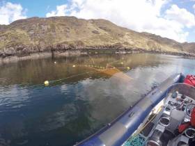
#MarineNotice - Inland Fisheries Ireland (IFI) will be carrying out scientific sampling using bag nets and sentinel cages in Killary Harbour and surrounding waters.
Similar to last year’s operation, the bag nets will start at the shore and extend into the water approximately 25 meters. The sentinel cages (nets) will be anchored near shore and will not interfere with navigable waters.
All nets will be clearly marked with brightly coloured buoys with IFI identification so that any unintentional retrieval can be notified.
Deployment operations, which were set to begin on Thursday 12 April, are being carried out using the RIB Sea Breeze (Callsign EI-5724) and are subject to weather conditions. The nets will be checked daily, also weather dependent, and all sampling nets and buoys will be retrieved on Friday 8 June.
Full details of co-ordinates and contact information are included in Marine Notice No 17 of 2018, a PDF of which is available to read or download HERE.
Bag-Nets & Sentinel Cages Deployed At Killary Harbour
#MarineNotice - Inland Fisheries Ireland (IFI) will be carrying out scientific sampling using bag-nets and sentinel cages in Killary Harbour and surrounding waters from this week.
The bag-nets will start at the shore and extend into the water approximately 25 metres. The sentinel cages (nets) will be anchored near-shore and will not interfere with navigable waters.
All nets will be clearly marked with brightly coloured buoys with IFI identification so that any unintentional retrieval can be notified to IFI through the contact details provided.
Deployment operations will be carried out using an IFI RIB, Sea Breeze (Callsign EI-5724; MMSI 250002937), and will take place today Monday 3 April, subject to weather conditions. The nets will be checked daily (weather dependent) and all sampling nets and buoys will be retrieved on Friday 2 June.
A map and co-ordinates of the relevant locations are included in Marine Notice No 16 of 2017, a PDF of which is available to read or download HERE.
Stormy Weather Exposes Shipwreck Near Killary Harbour
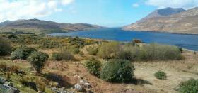
#Archaeology - With yet another stormy weekend comes news that continued coastal erosion on the West Coast has exposed the remains of a shipwreck at Killary Harbour.
According to The Irish Times, the wreck on Tallaghbaun Strand is already known to locals though its origins are as yet unclear.
But archaeologist Michael Gibbons believes it could date from the late medieval period, as wrecks from the Spanish Armada have been identified in the region.
Gibbons has also been researching what appear to be the remains of a late Bronze Age or early Christian monastic site on Kid Island in Broadhaven Bay. The Irish Times has more on the story HERE.
Connemara Mussel Farmer Dies In Diving Incident
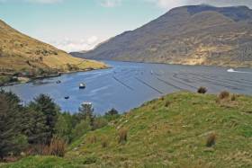
#Killary - The Irish Times reports on the death of a mussel farmer in a diving incident in Connemara at the weekend.
Marty Nee, who started a farm for rope-grown mussels in the area with his wife Catherine 16 years ago, died after getting into difficulty while diving in Killary Fjord on Saturday evening.
The loss of the 48-year-old Renvyle resident – a regular supplier to the annual Connemara Mussel Festival – has shocked the local community, according to Galway Bay FM.
Living the Wildlife Visits 'Underwater Ireland'

#DIVING ON TV - The latest episode of RTÉ One's natural history series Living the Wildlife takes a look at the secrets of 'Underwater Ireland'.
Presenter Colin Stafford-Jones goes diving with renowned underwater wildlife photographer Nigel Motyer, who has had photographs published in National Geographic magazine, to find a conger eel in Killary Harbour, Co Mayo.
Killary is Ireland's only fjord, which means that diving is possible all year round. But SCUBA diving is not the only way to access the underwater world - snorkelling is a cheaper and more practical way, as Victor Kutischev of the website Underwater Ireland demonstrates.
"Victor has seen some remarkable things over the last few years," says Stafford-Jones. "The triggerfish he filmed in Kerry, which we see in the show look absolutely extraordinary; it makes me want to throw on a mask and snorkel right now."
Stafford-Jones also visits old friend Dave Tilley on Sandymount Strand in Dublin Bay, where he shows how to gather a sustainable lunch from the clean waters of the bay - such as the razor clams regularly found on our beaches.
Catch the programme again tomorrow night (Monday 5 November) at 8.30pm on RTÉ One, or click HERE to view via RTÉ Player (available till 22 November in Ireland only).
Diver Treated for 'The Bends' in Northern Ireland
#DIVING - BBC News reports that a man suspected to be suffering from 'the bends' after a dive in Galway was treated in Northern Ireland at the weekend.
The diver was airlifted to the decompression chamber in Craigavon by Irish Coast Guard helicopter as there was no medical team available at the closest facility in Galway.
Decompression sickness - commonly known as 'the bends' - was suspected after the man's rapid ascent from a 22-metres dive in Killary Harbour on Sunday.


