Menu

Ireland's sailing, boating & maritime magazine

Dublin Bay Boating News and Information

Displaying items by tag: Lagan Canal

Nearly five years after work began, the first new boat lock on the Lagan Canal in more than 250 years is set to open tomorrow, Tuesday 17 May.

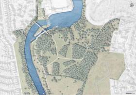
The new £4+ million Lock Number 1 at Stranmillis is part of a project to reopen the Lagan Canal to navigation from Belfast Lough to Lough Neagh, according to the Belfast Telegraph.

Regeneration of the canal includes a pedestrian and cycle bridge over the lock that was opened last autumn.

At 11am tomorrow morning the first boats since the canal was closed to commercial traffic in the 1950s will pass the lock in a special ceremony hosted by the Lagan branch of the Inland Waterways Association of Ireland with Belfast City Council.

The Belfast Telegraph has more on the story HERE.

Published in Inland Waterways
Tagged under

#InlandWaters - Work has begun on the restoration of the Lagan Canal from Belfast to Lough Neagh, according to the Belfast Telegraph.

The £4 million scheme to reopen the 27-mile inland waterway, which dates from the 18th century, provides for the first new boat lock in Belfast for more than 250 years, as previously reported on Afloat.ie.

It’s understood that works on the weir in Stranmills will be completed by next spring, allowing for proper regulation of water flows ahead of the canal’s future reopening to traffic alongside the already popular towpath.

The Belfast Telegraph has more on the story HERE.

Published in Inland Waterways
Tagged under

#LaganCanal - Belfast will get its first new boat lock in more than 250 years as work begins on a £4 million project near Belfast Boat Club.

As ITV News reports, the new lock plan — which includes a weir and pedestrian bridge at Stranmills — is part of a proposal to reopen the Lagan Canal to navigation and revive the legacy locks along an inland waterway that’s proven popular with cyclists and walkers.

The Lagan Canal, which once connected Lough Neagh with Belfast Lough, was closed in 1958. Its central section was destroyed by the building of the M1 motorway in the 1960s.

Published in Inland Waterways
Tagged under

#InlandWaters - A dilapidated building on the Lagan Canal that once served as home for the waterway's manager will get a new lease of life as the headquarters of the Lagan Canal Trust.

As the Belfast Telegraph reports, Navigation House, built in 1866 at Lisburn's Union Locks, was sold off in the 1950s and more recently was slated for demolition.

But after a listing by then NI Environment Minister Alex Attwood in 2012, the property was acquired by the National Trust's Hearth Revolving Fund and leased to the Lagan Canal Trust, which has announced plans to once again make it the most important building on the canal.

It's hoped to host an interpretive centre in the house to educate visitors on the history of the canal and its importance to Northern Ireland.

And it may also become a focal point in opening the Lagan Navigation to the wider community through angling, canoeing, walking, cycling and other activities.

The Belfast Telegraph has more on the story HERE.

Published in Inland Waterways
Lesser Spotted Ulster's Joe Mahon was on hand to launch the first comprehensive free visitor's guide to the Lagan Canal recently, the Ulster Star reports.
The new guide provides information on the canal's storied history and its abundance of wildlife from Belfast to Lough Neagh.
Lagan Canal Restoration Trust manager Cathy Burns said: “For the first time this guide offers visitors details of all there is to see and do along the canal.
"We hope that it encourages many more visitors and local people to take the opportunity to get out and experience the hidden gem that is the Lagan Canal."
A Guide to the Lagan Canal, Past, Present and Future is available to download online at lagancanaltrust.org

Lesser Spotted Ulster's Joe Mahon was on hand to launch the first comprehensive free visitor's guide to the inland waterway's Lagan Canal recently, the Ulster Star reports.

The new guide provides information on the canal's storied history and its abundance of wildlife from Belfast to Lough Neagh.

Lagan Canal Restoration Trust manager Cathy Burns said: “For the first time this guide offers visitors details of all there is to see and do along the canal.

"We hope that it encourages many more visitors and local people to take the opportunity to get out and experience the hidden gem that is the Lagan Canal."

A Guide to the Lagan Canal, Past, Present and Future is available to download online at lagancanaltrust.org.

Published in Inland Waterways

Dublin Bay

Dublin Bay on the east coast of Ireland stretches over seven kilometres, from Howth Head on its northern tip to Dalkey Island in the south. It's a place most Dubliners simply take for granted, and one of the capital's least visited places. But there's more going on out there than you'd imagine.

The biggest boating centre is at Dun Laoghaire Harbour on the Bay's south shore that is home to over 1,500 pleasure craft, four waterfront yacht clubs and Ireland's largest marina.

The bay is rather shallow with many sandbanks and rocky outcrops, and was notorious in the past for shipwrecks, especially when the wind was from the east. Until modern times, many ships and their passengers were lost along the treacherous coastline from Howth to Dun Laoghaire, less than a kilometre from shore.

The Bay is a C-shaped inlet of the Irish Sea and is about 10 kilometres wide along its north-south base, and 7 km in length to its apex at the centre of the city of Dublin; stretching from Howth Head in the north to Dalkey Point in the south. North Bull Island is situated in the northwest part of the bay, where one of two major inshore sandbanks lie, and features a 5 km long sandy beach, Dollymount Strand, fronting an internationally recognised wildfowl reserve. Many of the rivers of Dublin reach the Irish Sea at Dublin Bay: the River Liffey, with the River Dodder flow received less than 1 km inland, River Tolka, and various smaller rivers and streams.

Dublin Bay FAQs

There are approximately ten beaches and bathing spots around Dublin Bay: Dollymount Strand; Forty Foot Bathing Place; Half Moon bathing spot; Merrion Strand; Bull Wall; Sandycove Beach; Sandymount Strand; Seapoint; Shelley Banks; Sutton, Burrow Beach

There are slipways on the north side of Dublin Bay at Clontarf, Sutton and on the southside at Dun Laoghaire Harbour, and in Dalkey at Coliemore and Bulloch Harbours.

Dublin Bay is administered by a number of Government Departments, three local authorities and several statutory agencies. Dublin Port Company is in charge of navigation on the Bay.

Dublin Bay is approximately 70 sq kilometres or 7,000 hectares. The Bay is about 10 kilometres wide along its north-south base, and seven km in length east-west to its peak at the centre of the city of Dublin; stretching from Howth Head in the north to Dalkey Point in the south.

Dun Laoghaire Harbour on the southside of the Bay has an East and West Pier, each one kilometre long; this is one of the largest human-made harbours in the world. There also piers or walls at the entrance to the River Liffey at Dublin city known as the Great North and South Walls. Other harbours on the Bay include Bulloch Harbour and Coliemore Harbours both at Dalkey.

There are two marinas on Dublin Bay. Ireland's largest marina with over 800 berths is on the southern shore at Dun Laoghaire Harbour. The other is at Poolbeg Yacht and Boat Club on the River Liffey close to Dublin City.

Car and passenger Ferries operate from Dublin Port to the UK, Isle of Man and France. A passenger ferry operates from Dun Laoghaire Harbour to Howth as well as providing tourist voyages around the bay.

Dublin Bay has two Islands. Bull Island at Clontarf and Dalkey Island on the southern shore of the Bay.

The River Liffey flows through Dublin city and into the Bay. Its tributaries include the River Dodder, the River Poddle and the River Camac.

Dollymount, Burrow and Seapoint beaches

Approximately 1,500 boats from small dinghies to motorboats to ocean-going yachts. The vast majority, over 1,000, are moored at Dun Laoghaire Harbour which is Ireland's boating capital.

In 1981, UNESCO recognised the importance of Dublin Bay by designating North Bull Island as a Biosphere because of its rare and internationally important habitats and species of wildlife. To support sustainable development, UNESCO’s concept of a Biosphere has evolved to include not just areas of ecological value but also the areas around them and the communities that live and work within these areas. There have since been additional international and national designations, covering much of Dublin Bay, to ensure the protection of its water quality and biodiversity. To fulfil these broader management aims for the ecosystem, the Biosphere was expanded in 2015. The Biosphere now covers Dublin Bay, reflecting its significant environmental, economic, cultural and tourism importance, and extends to over 300km² to include the bay, the shore and nearby residential areas.

On the Southside at Dun Laoghaire, there is the National Yacht Club, Royal St. George Yacht Club, Royal Irish Yacht Club and Dun Laoghaire Motor Yacht Club as well as Dublin Bay Sailing Club. In the city centre, there is Poolbeg Yacht and Boat Club. On the Northside of Dublin, there is Clontarf Yacht and Boat Club and Sutton Dinghy Club. While not on Dublin Bay, Howth Yacht Club is the major north Dublin Sailing centre.

© Afloat 2020