Menu

Ireland's sailing, boating & maritime magazine

Dublin Bay Boating News and Information

Displaying items by tag: Limerick Port

#RecordGrowth - Limerick and Foynes both key ports of Shannon Foynes Port Company have reaffirmed the company’s strong performance and contribution to the regional economy in 2016 with growth of 11.4% in year on year tonnages.

For the second successive year, the two largest directly managed SFPC ports have now delivered 10% plus growth, significantly ahead of national and international standards.

Overall tonnages delivered across the company’s activities last year were at just over 11m, marginally behind the company’s record tonnage levels and reflecting the very significant resurgence at the company over the past five years. The tonnage increases were largely driven by strong performing sectors such as construction, oil distribution, agri and renewables.

The growth levels are also in excess of the upper end scenarios envisaged in the company’s Vision 2041 Masterplan published in 2014 and validate, SFPC CEO Patrick Keating states, the ongoing programme of infrastructural investment in quay infrastructure and land capacity.

Furthermore, he states, they reinforce again the growing need for the upgrade of Limerick to Foynes road network, without which the company’s ability to maintain growth and help drive the regional economy.

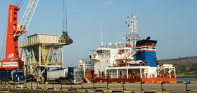
Reflecting specifically on the 2016 tonnage breakdown, Mr Keating said that while growth at the two premier ports was very positive, tonnages at Limerick really stood out. “The tonnages at Limerick Docks are particularly impressive as our tonnages last year were unprecedented and illustrate again the value and importance of Limerick Docks as a viable port not just for SFPC but for the region. Exports from Limerick docks more than tripled imports in 2016 so that shows just how much an asset it is for business in Limerick and the wider region.

“We have a long term plan for our property in the Limerick Docklands area but this will primarily be centred on maximising the docks as working port and improving connectivity thereto.

Mr Keating added “We have just completed a Limerick Docklands Framework Strategy that maps out the future requirements for the working port at Limerick, as well as plans to reinstate historical buildings such as Bannatyne Mills over time. This Strategy will be launched shortly and we are confident it will have a very positive economic and visual impact on the Dock Road area based on our stakeholder consultations.”

In keeping with its previously announced capital expenditure plans, 2016 also saw the company complete Phase 1 (€12m) of its expansion programme in Foynes.

It also recently acquired a further 90 acres for storage and port development purposes to facilitate growth in Foynes and will lodge a planning application for further multiple phases of its current €50m capital investment programme shortly.

Published in Shannon Estuary

Dublin Bay

Dublin Bay on the east coast of Ireland stretches over seven kilometres, from Howth Head on its northern tip to Dalkey Island in the south. It's a place most Dubliners simply take for granted, and one of the capital's least visited places. But there's more going on out there than you'd imagine.

The biggest boating centre is at Dun Laoghaire Harbour on the Bay's south shore that is home to over 1,500 pleasure craft, four waterfront yacht clubs and Ireland's largest marina.

The bay is rather shallow with many sandbanks and rocky outcrops, and was notorious in the past for shipwrecks, especially when the wind was from the east. Until modern times, many ships and their passengers were lost along the treacherous coastline from Howth to Dun Laoghaire, less than a kilometre from shore.

The Bay is a C-shaped inlet of the Irish Sea and is about 10 kilometres wide along its north-south base, and 7 km in length to its apex at the centre of the city of Dublin; stretching from Howth Head in the north to Dalkey Point in the south. North Bull Island is situated in the northwest part of the bay, where one of two major inshore sandbanks lie, and features a 5 km long sandy beach, Dollymount Strand, fronting an internationally recognised wildfowl reserve. Many of the rivers of Dublin reach the Irish Sea at Dublin Bay: the River Liffey, with the River Dodder flow received less than 1 km inland, River Tolka, and various smaller rivers and streams.

Dublin Bay FAQs

There are approximately ten beaches and bathing spots around Dublin Bay: Dollymount Strand; Forty Foot Bathing Place; Half Moon bathing spot; Merrion Strand; Bull Wall; Sandycove Beach; Sandymount Strand; Seapoint; Shelley Banks; Sutton, Burrow Beach

There are slipways on the north side of Dublin Bay at Clontarf, Sutton and on the southside at Dun Laoghaire Harbour, and in Dalkey at Coliemore and Bulloch Harbours.

Dublin Bay is administered by a number of Government Departments, three local authorities and several statutory agencies. Dublin Port Company is in charge of navigation on the Bay.

Dublin Bay is approximately 70 sq kilometres or 7,000 hectares. The Bay is about 10 kilometres wide along its north-south base, and seven km in length east-west to its peak at the centre of the city of Dublin; stretching from Howth Head in the north to Dalkey Point in the south.

Dun Laoghaire Harbour on the southside of the Bay has an East and West Pier, each one kilometre long; this is one of the largest human-made harbours in the world. There also piers or walls at the entrance to the River Liffey at Dublin city known as the Great North and South Walls. Other harbours on the Bay include Bulloch Harbour and Coliemore Harbours both at Dalkey.

There are two marinas on Dublin Bay. Ireland's largest marina with over 800 berths is on the southern shore at Dun Laoghaire Harbour. The other is at Poolbeg Yacht and Boat Club on the River Liffey close to Dublin City.

Car and passenger Ferries operate from Dublin Port to the UK, Isle of Man and France. A passenger ferry operates from Dun Laoghaire Harbour to Howth as well as providing tourist voyages around the bay.

Dublin Bay has two Islands. Bull Island at Clontarf and Dalkey Island on the southern shore of the Bay.

The River Liffey flows through Dublin city and into the Bay. Its tributaries include the River Dodder, the River Poddle and the River Camac.

Dollymount, Burrow and Seapoint beaches

Approximately 1,500 boats from small dinghies to motorboats to ocean-going yachts. The vast majority, over 1,000, are moored at Dun Laoghaire Harbour which is Ireland's boating capital.

In 1981, UNESCO recognised the importance of Dublin Bay by designating North Bull Island as a Biosphere because of its rare and internationally important habitats and species of wildlife. To support sustainable development, UNESCO’s concept of a Biosphere has evolved to include not just areas of ecological value but also the areas around them and the communities that live and work within these areas. There have since been additional international and national designations, covering much of Dublin Bay, to ensure the protection of its water quality and biodiversity. To fulfil these broader management aims for the ecosystem, the Biosphere was expanded in 2015. The Biosphere now covers Dublin Bay, reflecting its significant environmental, economic, cultural and tourism importance, and extends to over 300km² to include the bay, the shore and nearby residential areas.

On the Southside at Dun Laoghaire, there is the National Yacht Club, Royal St. George Yacht Club, Royal Irish Yacht Club and Dun Laoghaire Motor Yacht Club as well as Dublin Bay Sailing Club. In the city centre, there is Poolbeg Yacht and Boat Club. On the Northside of Dublin, there is Clontarf Yacht and Boat Club and Sutton Dinghy Club. While not on Dublin Bay, Howth Yacht Club is the major north Dublin Sailing centre.

© Afloat 2020