Displaying items by tag: Limerick navigation
Inland Navigations of Ireland Historical Society Hosts Limerick Navigation Conference
Inland Navigations of Ireland Historical Society are holding a One Day Conference in March on the Limerick Navigation.
Speakers on the day include Dr Joachim Fischer who will talk about the Construction of Ardnacrusha and Brian Goggin on 'Killaloe an Open Museum'. See the full programme below.
The conference is being held in partnership with In partnership with The Inland Waterways Association of Ireland, The Heritage Boat Association and Waterways Ireland will be held on Saturday, 11th March 2017 in the Hugh Lynch Function Room in Tullamore, County Offaly.
| Speaker | Subject | Time |
| Registration | Tea available | 9-9.15 |
| John Dolan President IWAI | Welcome Opening Address | 9.15 |
| Brian Wison | Chair | |
| Una Kierse | Killaloe | 9.20-9.50 |
| Brian H Goggin | Killaloe an Open Museum | 9.55-10.15 |
| Tea available | 10.15-10.20 | |
| Pat Lysaght | Chair | |
| Dr Charlotte Murphy | The Limerick Navigation | 10.20-10.50 |
| Mick Murtagh | Castleconnell, O'Briensbridge | 10.55-11.15 |
| Sharon Slater | Plassey, Limerick and the Black Bridge | 11.20-11.50 |
| Dr Joachim Fischer | Constructing Ardnacrusha | 11.55.-12.15 |
| Dr William O'Connor | After Ardnacrusha | 12.20-12.50 |
| Lunch | 12.50 -13.30 | |
| Denise MaCauliffe | Chair | |
| Tony Browne | Limerick City | 13.30-13.50 |
| Gary McMahon | Historic Boats of Limerick | 13.55-14.15 |
| Jim Lawless | Limerick Boating Today | 14.20-14.50 |
| Tea available | ||
| Mary Moore | Chair | |
| Noel Griffin | Using the Limerick Waterway | 14.55-15.15 |
| Paul Scannell | Beyond the Limerick Waterway | 15.20-15.50 |
| Éanna Rowe | Lough Derg and the Limerick Waterway | 15.55-16.10 |
| Brian H Goggin | Overview and Closing Address | 16.15-16.30 |
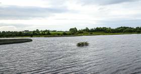
Limerick Navigation to Reopen in July
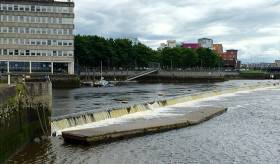
Calls to reopen the Limerick navigation between Parteen Weir and the city have been answered as Waterways Ireland confirmed that the infrastructural repair works needed would begin this week writes Andrew Carey.
As Afloat.ie reported previously, damage to floating pontoons and a breakwater at the Abbey River forced the closure of the navigation until Waterways Ireland identified a number of repair options for the damaged infrastructure along the Abbey and Shannon rivers.
Boaters, local Councillors, sitting TDs and the business community in Limerick issued calls for Ministerial intervention to reopen the waterway after it closed on April 25 last.
A spokesperson for Waterways Ireland said that "the stretch of navigation from Limerick city to Parteen Weir has been closed to navigation due to continuing infrastructural deficiencies as a result of the winter storms and subsequent flooding.
"The navigation remains closed and users are advised to stay clear of the damaged facilities in the area.
With additional funding sought from the Department of Arts, Heritage and the Gaeltacht, Waterways Ireland said that it had "limited resources and has had to prioritise its' interventions in those areas of greatest need and use."
However, this Wednesday, the agency said that "following inspections of the floating breakwater and the waiting jetties, a number of design solutions have been advanced to repair and re-instate the infrastructure.
"Works are commencing this week and it is expected that navigation in Limerick will be re-opened in three to four weeks."
The news has been broadly welcomed by leisure boat users and the business community who said that an indefinite closure of the navigation would effect tourism revenues and jobs in the area.
Last year, a six point plan to boost marine tourism on the Shannon and in Limerick was launched by then Education Minister Jan O'Sullivan.
The plans, drafted by Limerick marine enthusiasts to benefit local tourism, heritage and education, were submitted to Waterways Ireland.
Waterways Ireland said that they wished to take this opportunity "to apologise for the inconvenience caused to customers by this closure and wish to thank you for your patience and support in this matter."


