Displaying items by tag: Lough Muckno
Coarse Anglers Converge on Lough Muckno for World Feeder Club Championships This Weekend
Co Monaghan is hosting “the Olympics of angling” this weekend (Saturday 22 and Sunday 23 April) with the World Feeder Club Championships, as RTÉ News reports.
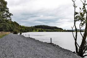
Lough Muckno is the venue for 28 teams representing 18 countries who will fish for the top prize in the competition hosted by the National Coarse Fishing Federation of Ireland (NCFFI).
Local anglers in the Cavan Monaghan Lakelands Feeder Club are joined by one other Irish team from Lurgan Coarse Angling Club in the international field that’s already been a hospitality boon for Castleblayney and environs.
RTÉ News has much more on the story HERE.
New €140,000 Angling Facility In Monaghan Hopes To Attract International Competitions
Enterprise Minister Heather Humphreys was on hand yesterday (Monday 29 July) to help Monaghan County Council open its new €140,000 angling facility at Lough Muckno in Castleblayney.
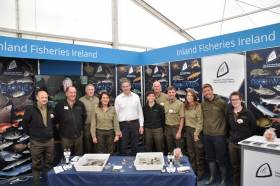
The upgraded facility, which was funded by Inland Fisheries Ireland (IFI) through its National Strategy for Angling Development, is hoped to attract international angling competitions and visiting anglers.
The fisheries development project saw the opening of an inaccessible angling stretch and the addition of 40 new coarse angling pegs along the shoreline which were required to cater for the lough’s growing number of anglers.
In addition, a new access point to the lough was developed for anglers incorporating 500m of road access, a vehicular access track beside the lake shore and new car parking spaces. IFI provided funding of €105,248 while Monaghan County Council contributed €35,000 to the project.
Minister Humphreys welcomed the upgrades. “Lough Muckno is a renowned angling destination and a valuable amenity to the community at large, offering significant value from both a tourism and recreational perspective. I am delighted to see investment in this facility which ensures it remains at international match standard,” she said.
The project is just one of many fisheries development schemes being delivered across the country under the National Strategy for Angling Development, which IFI touts as the first comprehensives national framework for the development of the angling resource.
The strategy provides opportunities for habitat improvement along with funding which will improve angling access and tourism development.
Cllr Seamus Coyle, Cathaoirleach of Monaghan County Council, said: “The development of this new stretch was required because of the success and popularity of the three previously developed sections on the lake.
“Because these stretches are regularly booked to capacity, it was important to provide another stretch to cater for all those who want to fish the lake and this is where South Lodge comes in.
“I have no doubt that this development will have a significant impact on the local economy and look forward to welcoming more international visitors to Castleblayney”
Dr Ciaran Byrne, IFI chief executive, added: “Lough Muckno has been extremely effective in attracting angling visitors to the town of Castleblaney over the years and this has had a positive economic impact on the area.
“It is fantastic to see rural communities engaging around the angling resource and we continue to support projects nationwide which look to support the improvement of fish habitats and remove barriers to accessing the fisheries resource.”
New Angling Bye-Laws For Lough Muckno, Lough Lene & River Vartry
#Angling - Three new angling bye-laws have been introduced in the Eastern River Basin District by Minister of State with responsibility for Inland Fisheries, Sean Kyne.
Conservation of Coarse Fish and Pike Dundalk District (Lough Muckno) Bye-law No 950, 2017 has been introduced for Lough Muckno, near Castleblaney in Co Monaghan.
This bye-law provides for catch and release for all coarse fish and pike on the lough. Anglers must use keep nets to hold any coarse fish or pike and all fish are to be subsequently released.
The regulations apply to Lough Muckno including Gas Lake and the waters up to Derrygreevy Bridge, the tributary up to Frankfort Bridge, County Water up to Wallace’s Bridge and the Clarebane River up to Clarebane Bridge.
On Lough Lene in Collinstown, Co Westmeath, the Annual Close Season Bye-law No 322, 2017 now applies.
This new bye-law has extended the open season such that anglers fishing for brown trout or rainbow trout can now fish from 1 March until 12 October.
On the River Vartry in Co Wicklow, the River Vartry System (Conservation Bag Limit) Bye-law No 952, 2017 has been introduced.
An angler is now permitted to take one sea trout (40cm or less) per day from the river during the open season, which runs from 1 March to 30 September. The River Vartry is closed for fishing for salmon and sea trout over 40cm.
All three bye-laws came into effect on 1 October 2017.
Inland Fisheries Ireland’s Dublin director Brian Beckett said: “These new bye-laws are designed to protect and conserve a range of fish species while supporting important angling amenity activities within the Eastern River Basin District.
“These fish populations are valuable from a number of perspectives including biological diversity and angling amenity and Inland Fisheries Ireland hope that these measures serve to reinforce the importance of protecting and conserving all our fisheries in the future.”
#ANGLING - Inland Fisheries Ireland will sponsor the European Police Coarse Angling Championships on Lough Muckno in Co Monaghan from 5-6 October 2012.
According to the Irish Angling Development Alliance (IADA), delegates from around Europe met at the Glencarn Hotel in Castleblaney last week to plan the event and visit local amenities.
The organising committee commented: “The response was so good that it now looks like 22 teams of five will be in attendance in the area for a period of approximately 10 days, with many team members, spouses and friends spending a further seven days after the event.”
Contingents from the Netherlands and Italy are expected to field the greatest number of teams competing in the championships, which bring with them a massive economic benefit for the region.
The IADA has much more on the story HERE.


