Menu

Ireland's sailing, boating & maritime magazine

Dublin Bay Boating News and Information

Displaying items by tag: Lough na Tooey

Creeslough & District Angling Association yesterday (Monday 17 June) opened its new angling facility at Lough na Tooey in North Donegal.

The facility, which was co-funded by Inland Fisheries Ireland (IFI) through its National Strategy for Angling Development, was officially launched by Sean Canney, Minister of State with responsibility for inland fisheries.

The facility at Creeslough is one aspect of a development project delivered by the local angling group which manages a number of salmon and trout fisheries in the area.

This project saw the improvement of angling access and infrastructure across three sites in the area: Lough na Tooey, Glen Lough and the Owencarrow River.

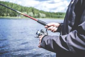
New facilities at Lough na Tooey include a slipway and mooring pontoon, boatshed and car park.

At Glen Lough, a new improved roadway over 1.2km leading to the angling site was constructed, while at Owencarrow, 15 stiles and ladders and 33 fishing stands were erected over 300m of the river bank.

IFI provided funding of over €216,000 with Creeslough & District Angling Association providing match funding of €30,000 to enable the completion of the project.

Minister Canney welcomed the project’s completion, saying: “The new facilities will enable safe and easier access to the fishery for the local community, while also supporting tourism in North Donegal.

“This is a first-class angling site located in a county renowned for its beautiful scenery and superb angling resource. As a result of this project, more local and visiting anglers will be fishing in the area, which in turn will provide both recreational and economic benefits for the community.”

IFI chief executive Dr Ciaran Byrne noted that Creeslough & District Angling Association “initiated and delivered these facilities on the ground by taking a collaborative approach and working across their entire fishery to identify where improvements were needed.

“Rural communities are engaging around the angling resource and demand for support continues apace. We look forward to partnering with more clubs and associations on the delivery of fisheries projects and will announce those successful in securing funding from our latest funding call over the coming months.”

Paddy Boyle of the Creeslough & District Angling Association said: “Fishing as a sport and recreation is dependent on the quality of the natural environment around us. Angling clubs have a role as custodians of this wonderful resource, and we owe it to future generations to look after the fish and their habitat.

“This development at Creeslough is proof of what angling clubs can achieve in partnership with local development agencies and Inland Fisheries Ireland. We asked for their help and got it because we presented them with a well thought-out plan for the conservation and development of our fisheries.”

Published in Angling

Dublin Bay

Dublin Bay on the east coast of Ireland stretches over seven kilometres, from Howth Head on its northern tip to Dalkey Island in the south. It's a place most Dubliners simply take for granted, and one of the capital's least visited places. But there's more going on out there than you'd imagine.

The biggest boating centre is at Dun Laoghaire Harbour on the Bay's south shore that is home to over 1,500 pleasure craft, four waterfront yacht clubs and Ireland's largest marina.

The bay is rather shallow with many sandbanks and rocky outcrops, and was notorious in the past for shipwrecks, especially when the wind was from the east. Until modern times, many ships and their passengers were lost along the treacherous coastline from Howth to Dun Laoghaire, less than a kilometre from shore.

The Bay is a C-shaped inlet of the Irish Sea and is about 10 kilometres wide along its north-south base, and 7 km in length to its apex at the centre of the city of Dublin; stretching from Howth Head in the north to Dalkey Point in the south. North Bull Island is situated in the northwest part of the bay, where one of two major inshore sandbanks lie, and features a 5 km long sandy beach, Dollymount Strand, fronting an internationally recognised wildfowl reserve. Many of the rivers of Dublin reach the Irish Sea at Dublin Bay: the River Liffey, with the River Dodder flow received less than 1 km inland, River Tolka, and various smaller rivers and streams.

Dublin Bay FAQs

There are approximately ten beaches and bathing spots around Dublin Bay: Dollymount Strand; Forty Foot Bathing Place; Half Moon bathing spot; Merrion Strand; Bull Wall; Sandycove Beach; Sandymount Strand; Seapoint; Shelley Banks; Sutton, Burrow Beach

There are slipways on the north side of Dublin Bay at Clontarf, Sutton and on the southside at Dun Laoghaire Harbour, and in Dalkey at Coliemore and Bulloch Harbours.

Dublin Bay is administered by a number of Government Departments, three local authorities and several statutory agencies. Dublin Port Company is in charge of navigation on the Bay.

Dublin Bay is approximately 70 sq kilometres or 7,000 hectares. The Bay is about 10 kilometres wide along its north-south base, and seven km in length east-west to its peak at the centre of the city of Dublin; stretching from Howth Head in the north to Dalkey Point in the south.

Dun Laoghaire Harbour on the southside of the Bay has an East and West Pier, each one kilometre long; this is one of the largest human-made harbours in the world. There also piers or walls at the entrance to the River Liffey at Dublin city known as the Great North and South Walls. Other harbours on the Bay include Bulloch Harbour and Coliemore Harbours both at Dalkey.

There are two marinas on Dublin Bay. Ireland's largest marina with over 800 berths is on the southern shore at Dun Laoghaire Harbour. The other is at Poolbeg Yacht and Boat Club on the River Liffey close to Dublin City.

Car and passenger Ferries operate from Dublin Port to the UK, Isle of Man and France. A passenger ferry operates from Dun Laoghaire Harbour to Howth as well as providing tourist voyages around the bay.

Dublin Bay has two Islands. Bull Island at Clontarf and Dalkey Island on the southern shore of the Bay.

The River Liffey flows through Dublin city and into the Bay. Its tributaries include the River Dodder, the River Poddle and the River Camac.

Dollymount, Burrow and Seapoint beaches

Approximately 1,500 boats from small dinghies to motorboats to ocean-going yachts. The vast majority, over 1,000, are moored at Dun Laoghaire Harbour which is Ireland's boating capital.

In 1981, UNESCO recognised the importance of Dublin Bay by designating North Bull Island as a Biosphere because of its rare and internationally important habitats and species of wildlife. To support sustainable development, UNESCO’s concept of a Biosphere has evolved to include not just areas of ecological value but also the areas around them and the communities that live and work within these areas. There have since been additional international and national designations, covering much of Dublin Bay, to ensure the protection of its water quality and biodiversity. To fulfil these broader management aims for the ecosystem, the Biosphere was expanded in 2015. The Biosphere now covers Dublin Bay, reflecting its significant environmental, economic, cultural and tourism importance, and extends to over 300km² to include the bay, the shore and nearby residential areas.

On the Southside at Dun Laoghaire, there is the National Yacht Club, Royal St. George Yacht Club, Royal Irish Yacht Club and Dun Laoghaire Motor Yacht Club as well as Dublin Bay Sailing Club. In the city centre, there is Poolbeg Yacht and Boat Club. On the Northside of Dublin, there is Clontarf Yacht and Boat Club and Sutton Dinghy Club. While not on Dublin Bay, Howth Yacht Club is the major north Dublin Sailing centre.

© Afloat 2020