Displaying items by tag: MV Lyubov Orlova
Ireland needs to appoint a Secretary of State’s Representative to deal with any future maritime or shipping incidents similar to the beaching of the MV Alta, a maritime expert advises.
Captain Neil Forde, a maritime consultant with Marine Hazard Ltd, tells the Irish Examiner that the ‘ghost ship’ which ran around in Ballycotton at the weekend is proving to be an “insurmountable bureaucratic obstacle” to measures to deal with the cargo ship, which underwent an environmental assessment yesterday (Tuesday 18 February).
“We are going to have a major maritime incident at some point, it is just inevitable … The county council, who even with the best will and intention is only going to be able to deal with small incidents, has been pushed into dealing with this by the current legislation,” he said.
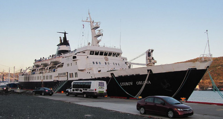
Another ‘ghost ship’, the MV Lyobov Orlova — its decks infested with ‘cannibal’ rats — could pose a biohazard threat to Ireland if it reached these shores.
A straightforward solution, Capt Forde suggests, is to appoint a single expert whose “job is to say to the different agencies ‘you are going to do this’, no ifs or buts about it, and to deal with the situation quickly”.
The Irish Examiner has more on the story HERE.
Ghost Ship Haunts Europe - But Still Nowhere To Be Found
#GhostShip - The 'ghost ship' MV Lyubov Orlova is back in the news this week, with renewed fears that she may visit her rat-infested decks upon the shores of Western Europe.
It's almost a year since the erstwhile polar cruise liner broke free from her cabling while being towed from eastern Canada to the Caribbean for scrapping, and her last known whereabouts in late February 2013 put her some 2,400km off the West of Ireland.
By October it was believed the vessel had "vanished from the high seas" though the Irish Coast Guard maintained there was every chance she was still adrift, posing a biohazard for Ireland if she ever reached our shores.
But the recent storms across the North Atlantic have put the Lyubov Orlova back on the agenda, making it more likely than ever that she's been driven closer to our coastline, or those of western Scotland and southwest England - if the extreme conditions haven't sunk the vessel, of course.
Sail World comments on the "star-crossed" history of the ship, which previously ran aground on a voyage in Antarctica, and was finally abandoned by her owners in Newfoundland over a financial dispute.
Much is also being made of the ship's 'cannibal' rats, presumed to have multiplied in great numbers on the derelict liner - and, because they have run out of other food sources, to be eating each other.
But as Irish Coast Guard chief Chris Reynolds tells The Irish Times, "it wouldn’t be at all unusual for there to be lots of rats", especially considering the ship lay empty in Canada for a year before its fateful transport.
Scare stories of rat infestations aside, there is a more clear and present concern: until there's final confirmation of the Lyubov Orlova's whereabouts, she remains a potential hazard to yachts and shipping traffic alike.
“The biggest risk," says Reynolds, "is something hitting it at speed in the dark.” More in The Irish Times HERE.

#Navigation - Marine navigation systems in yachting and shipping are 'primitive' compared to the standard in air travel, according to an electronics expert.
As Yachting Monthly reports, Martin Bransby of the UK's General Lighthouse Authorities said that "demands on marine navigation are only getting tighter, yet electronic systems at sea a primitive compared to those used in air travel. This needs to change."
Bransby made his comments following a trial to tackle the problem of rogue GPS jammers in the North Sea by the lighthouse authorities at Trinity House.
The new PNT (positioning, navigation and timing) method uses new technology to transmit critical data in the even of the loss or failure of GPS, which is vulnerable to interference from a variety of sources, both environmental and deliberate.
"The more dependent we become on electronic systems, the more resilient they must be," said Bransby. "Otherwise, we face a scenario where technology is actually reducing safety rather than enhancing it."
These new trials come after news that the Irish Coast Guard is collaborating on a new system of marine monitoring that will help detect drifting or rogue vessels in international waters before they become a problem for individual states - such as the 'ghost ship' MV Lyubov Orlova which as of last week was still adrift heading eastwards somewhere in the North Atlantic.
Missing 'Ghost Ship' Found 2,400km Off Ireland

#GhostShip - The missing 'ghost ship' MV Lyubov Orlova that has been adrift in the North Atlantic since the end of January has finally been located - some 2,400 off the West of Ireland.
US technology site Gizmodo reports on the discovery via the daily memorandum of the US National Geospatial-Intelligence Agency, which creates maps for top-secret military and civilian use.
It's not clear by what means the vessel was detected, as it has no lights and its Automatic Identification System (AIS) is switched off.
But it may be the result of efforts made by marine surveillance expert Guy Thomas, who has been working in collaboration with the Irish Coast Guard on a new system of marine monitoring called Global Maritime Awareness.
As previously reported on Afloat.ie, Thomas was contacted by Irish Coast Guard director Chris Reynolds amid concerns that the MV Lyubov Orlova might suddenly appear in Irish waters and become a burden on the State.
Responsibility for the vessel has already been disavowed by the Canadian authorities after the vessel, which was being towed from Canada to the Caribbean for scrapping, broke loose from its cabling.
Current information on the ghost ship's position indicates that it is being carried by Atlantic currents towards Europe.


