Displaying items by tag: Marine Notice
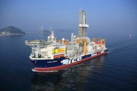
#MarineNotice - Providence Resources advises it intends to drill an exploration well in the Southern Porcupine Basin.
Operations were scheduled to begin today (Monday 3 July) to drill the well at a depth of 2,250 metres some 220km off the South West Coast of Ireland.
Drilling is expected to take 60 days to complete, subject to weather and operational delays.
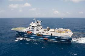
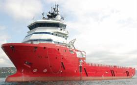
The dynamically positioned drill ship Stena IceMax (Callsign 2FMJ5) will carry out the drilling, supported by platform supply vessels Sjoborg (Callsign OZ-2075), Edda Frende (Callsign LCOB) and Skandi Flora (Callsign LEVX). The emergency rapid response vessel is Esvagt Don (Callsign MZWQ6).
There will be a safety exclusion zone of 500m radius from the drill ship. Regular safety messages will be broadcast on VHF Channel 16 by Esvagt Don throughout the project. Radio navigation warnings will also be issued several times daily by the Irish Coast Guard.
All vessels, particularly those engaged in fishing, are requested to give the Stena IceMax and accompanying vessels a wide berth and keep a sharp lookout in the relevant areas.
Full details of the drilling area are included in Marine Notice No 28 of 2017, a PDF of which is available to read or download HERE.
Mariners Beware Of Seabed Obstruction Off South Coast
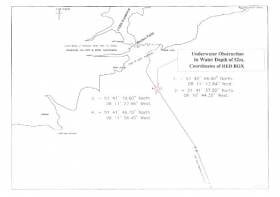
#MarineWarning - PSE Kinsale Energy Ltd advises that, that following a recent survey of the Kinsale Head Gas Field pipeline, it has identified a possible seabed obstruction off the South Coast of Ireland.
The nature of the obstruction, south-east of Roches Point on the approach to Cork Harbour, may present a hazard to ground fishing equipment, so any fishing vessels operating within the area are advised to proceed with caution.
Details of co-ordinates of the affected area are included in Marine Notice No 26 of 2017, a PDF of which is available to read or download HERE.
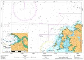
#MarineNotice - Shell E&P Ireland advises that inspection and engineering tasks will take place at the Corrib Gas Field and related offshore infrastructure from this month.
The work, due to commence in mid June and last for around 40 days, will include inspection of the offshore pipeline and subsea structure, inspection of the near shore pipeline, an umbilical lay at well P5, and a pipeline integrity test via ‘intelligent pig’ survey.
Visual and acoustic surveys will be conducted by means of vessel- and ROV-mounted sensors and cameras located on attendant survey vessels, ROVs and towed side scan sonar.
The Subsea Viking (callsign LJJL3) will undertake the deep water surveys and the subsea facilities maintenance and inspection. It will also carry out the umbilical lay and the intelligent pigging operation. All equipment used will be vessel and/or ROV mounted.
The An Gearoidin (callsign EIDL6) will undertake the inshore survey scope. All the equipment used will be vessel deployed.
Both vessels will be listening on VHF Channel 16 throughout the project.
Full details of the survey areas are included in Marine Notice No 25 of 2017, a PDF of which is available to read or download HERE.
Marine Notices: Seafarer Exam Dates, Fishing Vessel Code Reminder & ID For Recreational Craft
#MarineNotice - The Department of Transport, Tourism and Sport has posted its schedule of examination dates for Certificates of Competency for Deck Officers, Marine Engineer Officers, Skippers and Second Hands for the year commencing 1 September 2017, as detailed in Marine Notice No 21 of 2017.
Also recently published is a reminder to masters, owners and users of the requirements set out in the Code of Practice for the Design, Construction, Equipment and Operation of Small Fishing Vessels of less than 15m Length overall, with particular reference to the fitting of appropriate non-slip decking.
Marine Notice No 22 of 2017 comes on the foot of recommendations from the Marine Casualty Investigation Board in its report last year into an incident on a lobster boat off Donegal, in which a crewman died after falling overboard.
Finally, the Minister for Transport, Tourism and Sport has made a new Statutory Instrument that gives effect to an EU regulation on procedures for the identification of recreational craft and personal watercraft.
Full details of the new legislation are included in Marine Notice No 23 of 2017, a PDF of which is available to read or download HERE.
3D Seismic Survey Expended In Porcupine Basin
#MarineNotice - Geoscience company CGG’s 3D seismic survey in the Porcupine Basin extends from today (Saturday 20 May) for the next 50 days, weather dependent.
Joining the survey previously reported last month is the Geo Caspian (Callsign 3FCZ6), accompanied by the Bourbon Tern (Callsign 5BDQ4) and the Mariska G (Callsign HO7662).
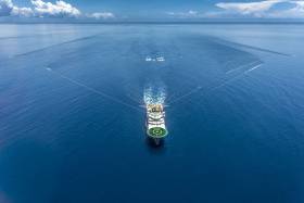
Yellow tail buoys will be towed at the end of each streamer, around 8.7km (4.7nm) behind the Geo Caspian. Each tail buoy will have a light flashing Morse code ‘U’ with an interval of approximately seven seconds.
Regular safety messaged will be broadcast from the Geo Caspian and its support vessels on VHF Channel 16 throughout the project.
Full details of the survey area are included in Marine Notice No 20 of 2017, a PDF of which is available to read or download HERE.
Sailors Beware Of ROV Visual Survey Off South West Coast
#MarineNotice - Sailors and other mariners off the South West Coast should keep on the lookout for a visual survey by remote operated vehicle currently being undertaken by PSE Kindle Energy Ltd.
The survey, which was set to commence on Tuesday 9 May, will run for the next three weeks in the environs of the Kinsale Head Gas Field, subject to weather conditions, and is being carried out from the Skandi Olympia (Callsign C6XY8).
The vessel will have an ROV deployed close to the seabed and its travel rate (survey rate) is approximately 0.4 knots over the ground on a weather-dependent heading.
Regular safety messages will be broadcast on VHF Channel 16. All vessels, and particularly those engaged in fishing, are requested to give the Skandi Olympia a wide berth and keep a sharp lookout in the revenant areas, as detailed in Marine Notice No 19 of 2017, a PDF of which is available to read or download HERE.
In case of any doubt, call the vessel on VHF and a safe course to follow will be given.
Seismic Survey Under Way In Porcupine Basin Till July
#MarineNotice - Geoscience company CGG is currently conducting a 3D seismic survey off the South West Coast of Ireland in the Porcupine Basin.
The three-month survey was scheduled to begin on Tuesday 11 April and will continue till Saturday 15 July. The vessels involved will be the Geo Coral (Callsign LACA8), Bourbon Tern (Callsign 5BDQ4), Marianne G (Callsign 3FTA9) and Stormbas 2 (Callsign V4EM2).
The Geo Coral is towing a multi-sensor streamer including 14 streamers with a 100m separation of an 8km length and a depth of 12 metres.
Yellow tail buoys will be towed at the end of each streamer, approximately 8.7km (4.7nm) behind the Geo Coral. Each tail buoy will have a light flashing Morse code 'U' with an interval of approximately 7 seconds.
There will be regular safety message broadcasting on VHF Channel 16 by the Geo Coral and accompanying vessels Marianne G and Stormbas 2 throughout the project. Seismic activity will be protected by support and chase vessels.
All vessels, particularly those engaged in fishing, are requested to give the Geo Coral and the towed equipment a wide berth and keep a sharp lookout in the relevant areas. In case of any doubt, call the Geo Coral on VHF Channel 16 and a safe course to follow will be given.
Full details of co-ordinates for the survey area are included in Marine Notice No 13 of 2017, a PDF of which is available to read or download HERE.
#Fishing - The Marine Institute will begin the annual Irish Anglerfish and Megrim Survey (IAMS 2017) off the North and North West Coasts from tomorrow (Saturday 8 June).
The 10-day operation, in fulfilment of Ireland’s Common Fisheries Policy (CFP) obligations, is a demersal trawl survey consisting of approximately 49 otter trawls (60 minutes) in ICES area 6a off Donegal – following on from a similar operation off the South Coast last month.
Fishing will take place within a three nautical mile radius of the positions indicated in Marine Notice 18 of 2017, a PDF of which is available to read or download HERE.
The RV Celtic Explorer (Callsign EIGB) will be used throughout the duration of the survey. The vessel will be towing a Jackson demersal trawl during fishing operations, will display appropriate lights and signals, and will be listening on VHF Channel 16 throughout.
Commercial fishing and other marine operators are requested to keep a 3nm area around the tow points clear of any gear or apparatus during the survey period.
Full co-ordinates of the survey area, as well as details for fishing operators with static gear within the survey zone, are included in the aforementioned Marine Notice.
#MarineNotice - PSE Kinsale Energy Limited will undertake a seabed survey off the South Coast of Ireland later this month.
The survey is to confirm the seabed status adjacent to subsea gas production infrastructure such as wellheads, manifolds, pipelines and umbilicals, collecting samples for analysis and undertaking multi-beam mapping of the seabed at select locations.
This survey, which forms part of ongoing field maintenance operations and provides information for future planning, is expected to commence on Thursday 13 April and last for approximately five to six days, subject to weather conditions.
The RV Celtic Voyager (Callsign EIQN) is scheduled to carry out the survey operations, which will take a number of seabed grab samples using a Van Veen Grab at predetermined locations, and will conduct multi-beam mapping of specific locations to assess the status of the subsea infrastructure in relation to the adjacent seabed.
A total of 31 seabed sampling stations and 15 multi-beam mapping locations are anticipated.
There will be a regular safety message broadcasting on VHF Channel 16 throughout the project. All vessels, particularly those engaged in fishing, are requested to give the RV Celtic Voyager a wide berth and keep a sharp lookout in the relevant areas.
Maps and co-ordinates of the survey areas are included in Marine Notice No 17 of 2017, available as a PDF to read or download HERE.
Bag-Nets & Sentinel Cages Deployed At Killary Harbour
#MarineNotice - Inland Fisheries Ireland (IFI) will be carrying out scientific sampling using bag-nets and sentinel cages in Killary Harbour and surrounding waters from this week.
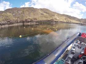
The bag-nets will start at the shore and extend into the water approximately 25 metres. The sentinel cages (nets) will be anchored near-shore and will not interfere with navigable waters.
All nets will be clearly marked with brightly coloured buoys with IFI identification so that any unintentional retrieval can be notified to IFI through the contact details provided.
Deployment operations will be carried out using an IFI RIB, Sea Breeze (Callsign EI-5724; MMSI 250002937), and will take place today Monday 3 April, subject to weather conditions. The nets will be checked daily (weather dependent) and all sampling nets and buoys will be retrieved on Friday 2 June.
A map and co-ordinates of the relevant locations are included in Marine Notice No 16 of 2017, a PDF of which is available to read or download HERE.

