Displaying items by tag: Marine wildlfife
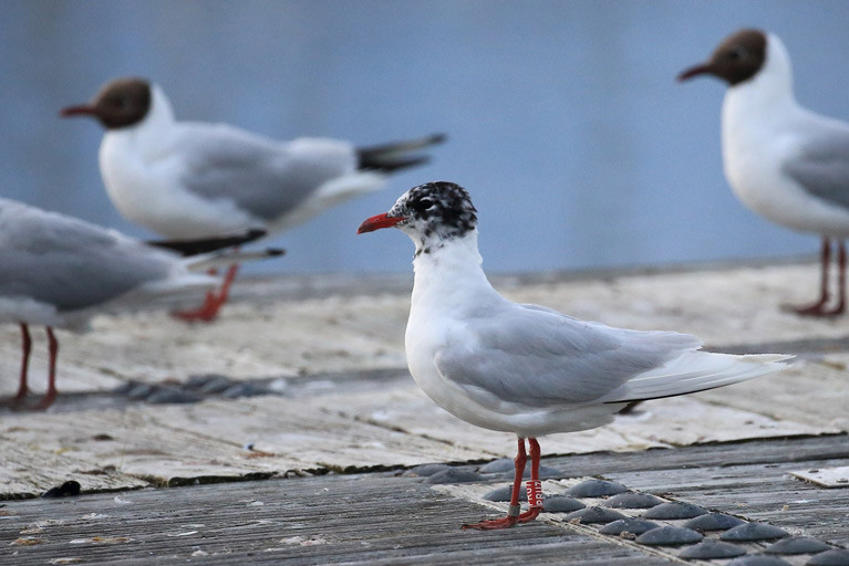
Bangor Marina on Belfast Lough in County Down welcomes visitors from far and wide, but this Mediterranean gull must be one of the most interesting, having travelled from Poland, Spain, and France before flying into Bangor.
Berth holder, wildlife expert and photographer Ronald Surgenor who works for the Ulster Wildlife Nature Reserves team, captured this wonderful photograph of the gull roosting on pontoon B. He was able to trace the bird’s movement via the red numbered ring on its leg. In 2015 the bird was ringed in Poland and over the next five years flew across Europe before flying into Bangor. A truly international visitor!
Ronald says “ Good chance it'll be around the roosting gulls for a while, always worth a quick check on the way past; the white wingtips help pick it out amongst the Black-headed gulls and their dark wingtips. I always carry the camera on the boat as you never know what you will see out on the water”.
As previously portrayed in Afloat.ie on 5th June, Bangor Harbour is a valuable haven for wildlife.
Basking Sharks off Kerry Have Different Genes to Cousins in Donegal
Basking sharks which were sampled off the west Kerry coast in early Spring have proved to be genetically different to all other such sharks tested in the north-east Atlantic, according to a newly published study writes Lorna Siggins.
The study on the migration routes of basking sharks also shows that the animals prefer to swim “en famille” to known feeding locations.
Researchers from the Galway-Mayo Institute of Technology (GMIT) participated in one of the most comprehensive studies of the genetics of one of the world’s largest fish.
The project findings, led by the University of Aberdeen, Scotland, were published this week in the journal, Scientific Reports.
Hunted off the south Irish coast by Norwegians until the 1980s, and off the west coast for the Achill fishery in the 1950s and 1960s, the basking shark is known among coastal communities as the “sunfish” due to its preference for swimming just below the surface.
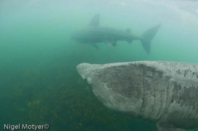 Two Basking Sharks Photo: Nigel Moyter
It is also known as “liop an dá” (unwieldy beast with two fins) or more generally “liabhán mór”, denoting a great leviathan.
It is protected in some waters and was recently classified on the International Union for Conservation of Nature “red list” for endangered species
The plankton-eating fish is distinctive for its open mouth. It has been estimated that a seven-metre shark, cruising wide-mouthed at a speed of two knots, will filter 1,484 cubic metres of sea-water per hour.
Basking sharks can grow to more than ten metres, can dive to depths of more than a thousand metres, and feed on plankton in areas of the northeast Atlantic including the west coast of Scotland, Ireland and the Isle of Man.
The researchers note that “up until recently very little was known” about their biology, as they only appear briefly at the sea surface each spring before “vanishing into the ocean depths”.
Through establishing a register of genetic profiles with regular swabbing, the researchers were able to identify individual basking sharks when they arrived to feed. The results revealed that the fish repeatedly returned to the same feeding sites in successive years.
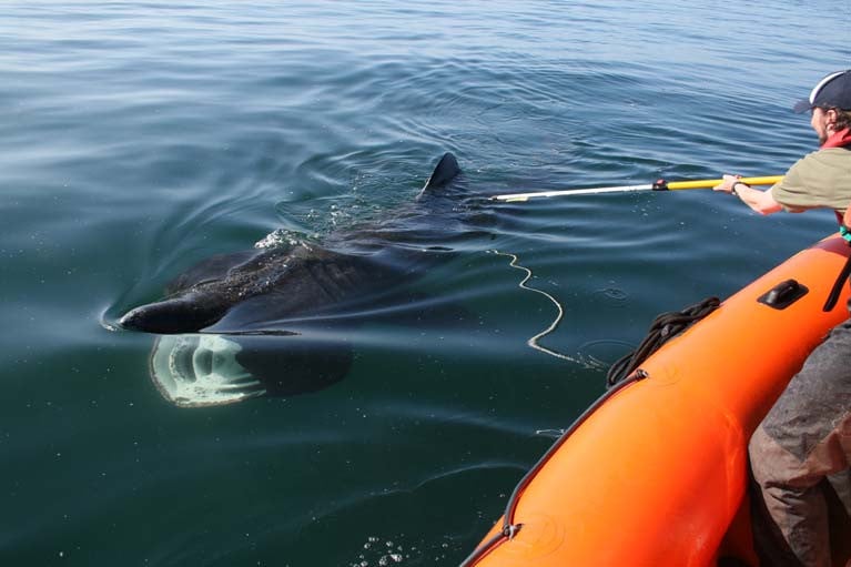
Fieldwork off Donegal by GMIT’s Dr Simon Berrow and Emmet Johnston of the Irish Basking Shark Study Group led to a “breakthrough” in sampling, by collecting skin mucus samples in large groups of sharks - quickly, and with minimum disturbance.
The researchers say that one of the “most surprising” findings among the “cosmopolitan” filter feeders is that basking sharks sampled off Ireland in spring were genetically distinct from other north-east Atlantic fish, including those sampled later in the year off Co Donegal.
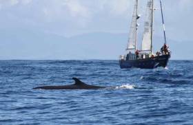
Humpback whales are one of the most iconic animals on the planet, ambassadors for the world’s oceans. The image of a humpback whale, with its fluke lifted clear of the water became the symbol of the environmental movement when a recording of the “Song of the Humpback” in the 1970s was credited with “opening the minds of the public to their world,” where their acrobatic breaching is one of the most sought-after wildlife images for photographers and film-makers worldwide.
Beneath the waves, male humpbacks produce a complex cetacean melodic sound to attract females, which is heard regularly amongst whales as they communicate with each other off the Irish coastline, even if not heard by humans!
Humpback whales are coming to Irish waters in increasing numbers to feed along the South and West coasts. The Irish Whale and Dolphin Group has documented 87 individual humpback whales in Irish waters, recognised by unique markings on their tail flukes and over one-half of these whales have been recorded in more than one year showing that they are returning to Irish waters. Some have been re-sighted in 12 of the past 17 years!
"Humpback whales are coming to Irish waters in increasing numbers to feed along the South and West coasts"
It has tracked some of them to Iceland and just announced that its research vessel, Celtic Mist (the former yacht of Charles Haughey) is going to Iceland to further investigate those links. The vessel will also carry out another, rather courageous in Iceland assignment, as Dr.Simon Berrow, Chief Scientific Officer of Group has been telling me. That assignment is to challenge the Icelandic decision to resume hunting fin whales.
Listen to Dr.Berrow detail what Celtic Mist and its crew will be doing.
Environmentalists In New Challenge Over Lough Neagh Sand Dredging
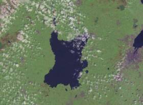
#LoughNeagh - Friends of the Earth (FoE) is appealing a ruling against its claims that Stormont is “turning a blind eye” to sand dredging in Lough Neagh, as the News Letter reports.
The environmental group brought the issue before the High Court last summer, when it described NI Environment Minister Mark Durkan’s 2015 decision to issue an enforcement notice against sand dredging, rather than an outright ban, as bringing “Northern Ireland into ridicule”.
As much as 1.5 million tonnes of sand is dredged from the lough each year, the charity has claimed, adding that dreading companies have continued the practice as their own challenge against the enforcement notice is pending with the Planning Appeals Commission.
Sand dredging has been carried out in Lough Neagh since the 1930s, and previously no planing permission was required, though the lough was designated as a Special Protection Area for wildlife in 1999.
In November, a judge rejected FoE’s High Court challenge, but the organisation has now appealed that decision.
“We believe the judge erred in law and didn’t take into account the significance of this major nature reserve,” said the charity’s NI director James Orr.
The News Letter has more on the story HERE.
Enormous Sharks Shut Australian Beaches For The Week
#MarineWildlife - Great white sharks that could "bite a person in half" have seen the closure of a stretch of beaches north of Sydney for more than a week, as TheJournal.ie reports.
One shark in particular, thought to be some five metres in length, is the largest ever spotted in the waters off Newcastle, some 160km north of Australia's biggest city.
Similarly sized sharks have also been witnessed nearby feeding on dolphins, with one of the ocean predators described as being "as big as a car".
For safety reasons, all beaches in these areas have been closed to bathing and surfing – popular activities for Irish expats and locals alike – until 24 hours have passed with no sightings.
TheJournal.ie has more on the story HERE.
Seas at Risk from Decline in Plankton
A major study published today in the journal Nature suggests that the marine food chain could be in danger of collapse due to declining levels of phytoplankton.
Phytoplankton are the bottom rung of the food chain on which all sea life depends.
Phytoplankon levels have dropped of by about 40 percent since 1950, and the Candadian scientists who authored the report link the decline to warming oceans.
"Phytoplankton is the fuel on which marine ecosystems run," said lead author Daniel Boyce, a professor at Dalhousie University in the Canadian province of Nova Scotia.
"A decline affects everything up the food chain, including humans."
The pace of the decline is heaviest in polar and tropical regions, and was in line with the speed at which surface ocean temperatures had changed there.
Phytoplankton get their energy from the sun, and need sunlight and nutrients to grow. They are the marine equivalent of grazing pasture.
With warmer oceans becoming more stratified, a "dead zone" can develop at the surface. Less vertical movement of water in the oceans means that fewer nutrients are delivered from deeper layers.
The findings are worrying, the researchers said.
"Phytoplankton are a critical part of our planetary support system - they produce half the oxygen we breathe, draw down surface carbon dioxide, and ultimately support all fisheries," said co-author Boris Worm.


