Displaying items by tag: Ms. Máire GeogheganQuinn
Minister Smith said "I am delighted to sign today a new Accord on Marine Research between Newfoundland and Labrador and the Irish Authorities. The initiative involves a partnership approach between the Fisheries and Marine Institute of Memorial University of Newfoundland and Ireland's Marine Institute including the charter of the state-of-the-art research vessel 'Celtic Explorer'. Both Institutes have strong capabilities in ocean technology and research. Through this alliance, there is now an opportunity to bring the strengths of both Institutes to greater levels".
Minister of State Connick added that "The proposed EU Atlantic Strategy under the EU Integrated Maritime Policy and the support for a Joint Programming Initiative on Healthy Seas & Oceans recently announced by Ms. Máire Geoghegan-Quinn the European Commissioner for Research, Innovation and Science, highlight the increasing importance of linking the scientific challenges on both sides of the Atlantic."
Welcoming the chartering of the RV Celtic Explorer, Mr Clyde Jackman, Minister for Fisheries and Aquaculture – Newfoundland said "It will enable our academic institutions to take their already world class research to the next level and support a state of the art fishing industry that is based on better science. This initiative will create many new opportunities for young Newfoundlanders and Labradorians, as a result of a more vibrant fishing industry and in conducting fisheries science research".
"Thanks to the support of our Provincial Government, the Marine Institute of Memorial University of Newfoundland is further positioned to play a vital role in the future of fisheries in Newfoundland and Labrador. With the chartering the RV Celtic Explorer and the creation of our new Centre for Fisheries Ecosystem Research the Marine Institute is further positioned to play a vital role in fisheries science research in our province," said Glenn Blackwood, the Executive Director of the Fisheries and Marine Institute of Memorial University of Newfoundland.
"Research lead by personnel from the Centre for Fisheries Ecosystem Research and conducted aboard the RV Celtic Explorer will help develop a better understanding of the state of Newfoundland and Labrador's fish stocks and the dynamics of its marine ecosystems, providing new information to support better decisions." he said.
"The strong alliance the Marine Institute, Ireland has with the Fisheries and Marine Institute of Memorial University of Newfoundland will enable transatlantic collaboration to support the rapidly expanding fisheries research programmes in Newfoundland waters" said Dr Peter Heffernan, CEO of the Marine Institute.
"We are delighted with this opportunity to work with such a prominent team of fisheries scientists and we look forward to exploring with our Newfoundland colleagues how we can also build stronger links as part of a wider international ocean observation initiative to study the Gulf Stream and North Atlantic Drift. This could link SMART technology to monitor climate change and environmental conditions in both Irish and Newfoundland waters and stimulate commercial spin off opportunities."
"Projects linking technologies, equipment and expertise on both sides of the Atlantic would therefore enhance Ireland and Newfoundland's capability to perform in the forefront of scientific endeavours as our strategic geographic location demands," he further added.
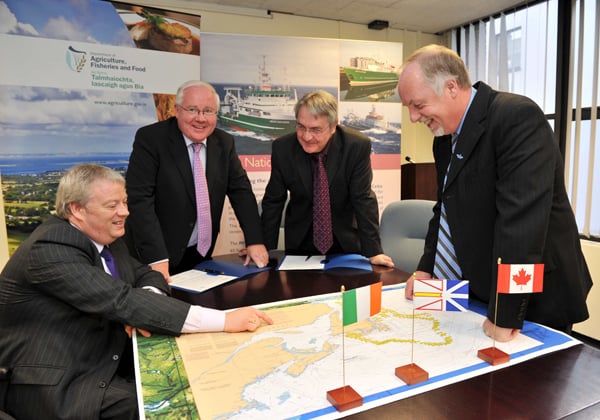
Brendan Smith TD, Minister for Agriculture, Fisheries and Food and Sean Connick TD, Minister of State at the Department of Agriculture, Fisheries and Food signing an accord with their Newfoundland counterparts Minister Clyde Jackman and Deputy Minister Alastair O’Reilly In Agriculture House.


