Menu

Ireland's sailing, boating & maritime magazine

Dublin Bay Boating News and Information

Displaying items by tag: NI Ports

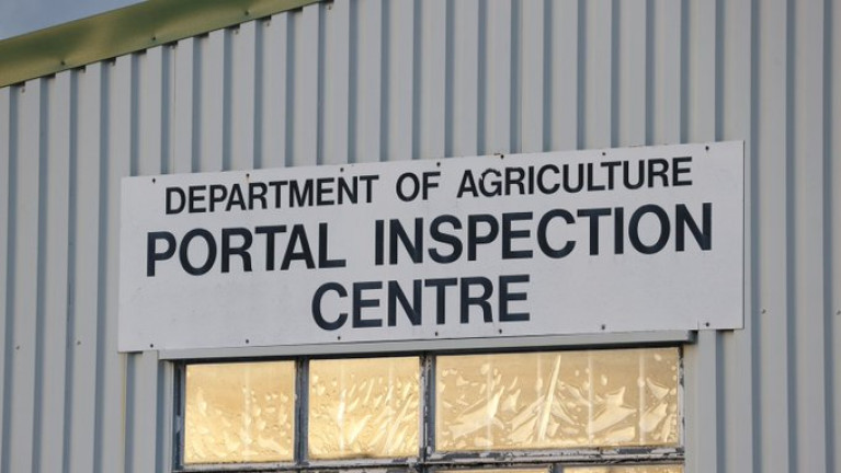
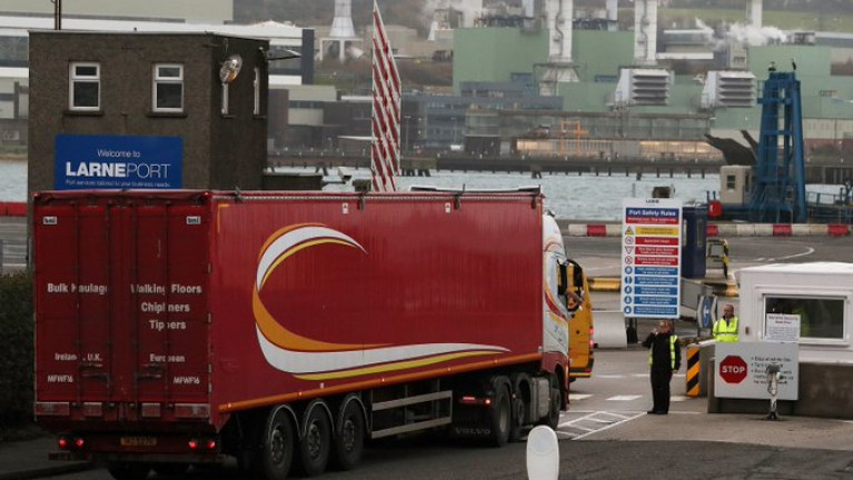
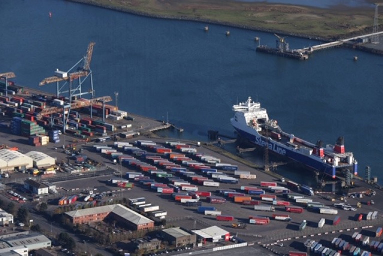
Northern Ireland's Department of Agriculture staff which were withdrawn from Brexit checks at two ports because of claims of threats last week return to work today.

According to RTE News, the decision to resume physical inspections of animal-based products in Belfast and Larne follows a threat assessment provided by police.

The checks were suspended on 1 February after threatening graffiti appeared in a number of loyalist areas warning that port staff could be "targets".

It was claimed that staff were being threatened by unspecified opponents of the Northern Ireland Protocol (see: related Article 16) which has resulted in inspections on some products arriving from Great Britain.

Many unionists and loyalists view this Irish Sea border as a threat to Northern Ireland’s constitutional position within the UK.

More here on this story.

Published in Ports & Shipping

The EU is seeking to have 15 customs and veterinary staff working alongside UK officials at ports and Belfast Airport to ensure the proper implementation of the Northern Ireland Protocol, RTÉ News understands.

In return, the EU would drop an earlier request to have a physical office in Belfast.

The issue was raised during a meeting this morning of the EU-UK Joint Committee, which officials have described as positive and constructive.

One official cautiously described the encounter in London as a potential "turning point" in the process of both sides having to agree how to implement the Protocol, which provides for customs and regulatory formalities on goods arriving in Northern Ireland from Great Britain, will work.

The meeting was led by the European Commission executive vice-president Maros Sefcovic and Michael Gove, a minister in the Cabinet Office.

More on this latest development here.

Published in Ports & Shipping

In the UK the Government, according to Belfast Telegraph, is set to pay for work on post-Brexit port checks in Northern Ireland, DAERA Minister Edwin Poots has said.

The DUP MLA told the BBC that the UK Government would now pay for the work after he reportedly proposed pausing it due to the current political uncertainty around Brexit.

In the summer, the Government said enhanced regulatory checks would be required on animals and food products crossing the Irish Sea from Great Britain to Northern Ireland under the terms of the Brexit deal.

The Executive assumed a legal responsibility to undertake the work for the Government to enable it to fulfil its international obligations under the Withdrawal Agreement.

However, Mr Poots expressed a reluctance to commit an estimated £40m to the project without further clarity. Click for more here

Published in Ports & Shipping
Tagged under

Dublin Bay

Dublin Bay on the east coast of Ireland stretches over seven kilometres, from Howth Head on its northern tip to Dalkey Island in the south. It's a place most Dubliners simply take for granted, and one of the capital's least visited places. But there's more going on out there than you'd imagine.

The biggest boating centre is at Dun Laoghaire Harbour on the Bay's south shore that is home to over 1,500 pleasure craft, four waterfront yacht clubs and Ireland's largest marina.

The bay is rather shallow with many sandbanks and rocky outcrops, and was notorious in the past for shipwrecks, especially when the wind was from the east. Until modern times, many ships and their passengers were lost along the treacherous coastline from Howth to Dun Laoghaire, less than a kilometre from shore.

The Bay is a C-shaped inlet of the Irish Sea and is about 10 kilometres wide along its north-south base, and 7 km in length to its apex at the centre of the city of Dublin; stretching from Howth Head in the north to Dalkey Point in the south. North Bull Island is situated in the northwest part of the bay, where one of two major inshore sandbanks lie, and features a 5 km long sandy beach, Dollymount Strand, fronting an internationally recognised wildfowl reserve. Many of the rivers of Dublin reach the Irish Sea at Dublin Bay: the River Liffey, with the River Dodder flow received less than 1 km inland, River Tolka, and various smaller rivers and streams.

Dublin Bay FAQs

There are approximately ten beaches and bathing spots around Dublin Bay: Dollymount Strand; Forty Foot Bathing Place; Half Moon bathing spot; Merrion Strand; Bull Wall; Sandycove Beach; Sandymount Strand; Seapoint; Shelley Banks; Sutton, Burrow Beach

There are slipways on the north side of Dublin Bay at Clontarf, Sutton and on the southside at Dun Laoghaire Harbour, and in Dalkey at Coliemore and Bulloch Harbours.

Dublin Bay is administered by a number of Government Departments, three local authorities and several statutory agencies. Dublin Port Company is in charge of navigation on the Bay.

Dublin Bay is approximately 70 sq kilometres or 7,000 hectares. The Bay is about 10 kilometres wide along its north-south base, and seven km in length east-west to its peak at the centre of the city of Dublin; stretching from Howth Head in the north to Dalkey Point in the south.

Dun Laoghaire Harbour on the southside of the Bay has an East and West Pier, each one kilometre long; this is one of the largest human-made harbours in the world. There also piers or walls at the entrance to the River Liffey at Dublin city known as the Great North and South Walls. Other harbours on the Bay include Bulloch Harbour and Coliemore Harbours both at Dalkey.

There are two marinas on Dublin Bay. Ireland's largest marina with over 800 berths is on the southern shore at Dun Laoghaire Harbour. The other is at Poolbeg Yacht and Boat Club on the River Liffey close to Dublin City.

Car and passenger Ferries operate from Dublin Port to the UK, Isle of Man and France. A passenger ferry operates from Dun Laoghaire Harbour to Howth as well as providing tourist voyages around the bay.

Dublin Bay has two Islands. Bull Island at Clontarf and Dalkey Island on the southern shore of the Bay.

The River Liffey flows through Dublin city and into the Bay. Its tributaries include the River Dodder, the River Poddle and the River Camac.

Dollymount, Burrow and Seapoint beaches

Approximately 1,500 boats from small dinghies to motorboats to ocean-going yachts. The vast majority, over 1,000, are moored at Dun Laoghaire Harbour which is Ireland's boating capital.

In 1981, UNESCO recognised the importance of Dublin Bay by designating North Bull Island as a Biosphere because of its rare and internationally important habitats and species of wildlife. To support sustainable development, UNESCO’s concept of a Biosphere has evolved to include not just areas of ecological value but also the areas around them and the communities that live and work within these areas. There have since been additional international and national designations, covering much of Dublin Bay, to ensure the protection of its water quality and biodiversity. To fulfil these broader management aims for the ecosystem, the Biosphere was expanded in 2015. The Biosphere now covers Dublin Bay, reflecting its significant environmental, economic, cultural and tourism importance, and extends to over 300km² to include the bay, the shore and nearby residential areas.

On the Southside at Dun Laoghaire, there is the National Yacht Club, Royal St. George Yacht Club, Royal Irish Yacht Club and Dun Laoghaire Motor Yacht Club as well as Dublin Bay Sailing Club. In the city centre, there is Poolbeg Yacht and Boat Club. On the Northside of Dublin, there is Clontarf Yacht and Boat Club and Sutton Dinghy Club. While not on Dublin Bay, Howth Yacht Club is the major north Dublin Sailing centre.

© Afloat 2020