Menu

Ireland's sailing, boating & maritime magazine

Dublin Bay Boating News and Information

Displaying items by tag: New Valentia ferry

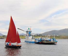
#NewFerry - The future of the Valentia Island ferry in Co Kerry remains in doubt as God Met Ons III dating to 1963, easily the country’s oldest domestic ferry, will no longer meets marine safety requirements, writes Jehan Ashmore.

The seasonal service linking Reenard Point on the mainland to Knightstown on Valentia, last year handled an impressive 250,000 passengers and 100,000 cars. The traffic handled by the 15 car capacity ferry on the crossing takes just five minutes to complete.

Commenting to Afloat, Richard Foran of Valentia Island Ferries cited costs to avoid decommissioning the ageing ferry with modification works would be too expensive. This compared to a replacement ferry in the region of €3 million.

Mr. Foran added that they have already consulted a naval architect on the Isle of Wight for designs of a custom-built but larger 18 car capacity ferry. In addition the new ferry would be capable of transporting large coaches unlike the current ferry. He also added to Afloat that they are looking at an Irish yard to build the new ferry. 

Islanders say that without a ferry replacement funded by the Irish Government, the tourism sector would collapse. The €3 million figure is beyond the reach of the island community from which five families established Valentia Island Ferries in 1996, however the operator said they can only contribute €1 million towards the cost of the newbuild.

The Minister for Transport, Tourism and Sport, Shane Ross and local independent T.D. Michael Healy Rae last month travelled to Valentia to meet the board of directors of Valentia Island Ferries to discuss possible funding of the new ferry. The ferry firm had previously applied to Fáilte Ireland for €2 million but this failed. Should the newbuild be granted state funding it would be built in time for the 2018 season

Originally, God Met Ons III ran for Dutch owners on the River Maas, but was sold to Valentia Island Ferries to operate the island’s first ever car-ferry service. Previously there had been a cargo boat service on the same route until a bridge was constructed in 1970, towards the west of the island linking Portmagee on the mainland.

Despite the bridge, islanders and tourist alike benefit from the ferry service that reduces 13 miles the distance to Cahersiveen, the nearest large mainland town.

The loop created by both bridge and ferry has been a boost to tourism in recent years since the launch of the Wild Atlantic Way that includes the Skelligs.

Published in Island News

Dublin Bay

Dublin Bay on the east coast of Ireland stretches over seven kilometres, from Howth Head on its northern tip to Dalkey Island in the south. It's a place most Dubliners simply take for granted, and one of the capital's least visited places. But there's more going on out there than you'd imagine.

The biggest boating centre is at Dun Laoghaire Harbour on the Bay's south shore that is home to over 1,500 pleasure craft, four waterfront yacht clubs and Ireland's largest marina.

The bay is rather shallow with many sandbanks and rocky outcrops, and was notorious in the past for shipwrecks, especially when the wind was from the east. Until modern times, many ships and their passengers were lost along the treacherous coastline from Howth to Dun Laoghaire, less than a kilometre from shore.

The Bay is a C-shaped inlet of the Irish Sea and is about 10 kilometres wide along its north-south base, and 7 km in length to its apex at the centre of the city of Dublin; stretching from Howth Head in the north to Dalkey Point in the south. North Bull Island is situated in the northwest part of the bay, where one of two major inshore sandbanks lie, and features a 5 km long sandy beach, Dollymount Strand, fronting an internationally recognised wildfowl reserve. Many of the rivers of Dublin reach the Irish Sea at Dublin Bay: the River Liffey, with the River Dodder flow received less than 1 km inland, River Tolka, and various smaller rivers and streams.

Dublin Bay FAQs

There are approximately ten beaches and bathing spots around Dublin Bay: Dollymount Strand; Forty Foot Bathing Place; Half Moon bathing spot; Merrion Strand; Bull Wall; Sandycove Beach; Sandymount Strand; Seapoint; Shelley Banks; Sutton, Burrow Beach

There are slipways on the north side of Dublin Bay at Clontarf, Sutton and on the southside at Dun Laoghaire Harbour, and in Dalkey at Coliemore and Bulloch Harbours.

Dublin Bay is administered by a number of Government Departments, three local authorities and several statutory agencies. Dublin Port Company is in charge of navigation on the Bay.

Dublin Bay is approximately 70 sq kilometres or 7,000 hectares. The Bay is about 10 kilometres wide along its north-south base, and seven km in length east-west to its peak at the centre of the city of Dublin; stretching from Howth Head in the north to Dalkey Point in the south.

Dun Laoghaire Harbour on the southside of the Bay has an East and West Pier, each one kilometre long; this is one of the largest human-made harbours in the world. There also piers or walls at the entrance to the River Liffey at Dublin city known as the Great North and South Walls. Other harbours on the Bay include Bulloch Harbour and Coliemore Harbours both at Dalkey.

There are two marinas on Dublin Bay. Ireland's largest marina with over 800 berths is on the southern shore at Dun Laoghaire Harbour. The other is at Poolbeg Yacht and Boat Club on the River Liffey close to Dublin City.

Car and passenger Ferries operate from Dublin Port to the UK, Isle of Man and France. A passenger ferry operates from Dun Laoghaire Harbour to Howth as well as providing tourist voyages around the bay.

Dublin Bay has two Islands. Bull Island at Clontarf and Dalkey Island on the southern shore of the Bay.

The River Liffey flows through Dublin city and into the Bay. Its tributaries include the River Dodder, the River Poddle and the River Camac.

Dollymount, Burrow and Seapoint beaches

Approximately 1,500 boats from small dinghies to motorboats to ocean-going yachts. The vast majority, over 1,000, are moored at Dun Laoghaire Harbour which is Ireland's boating capital.

In 1981, UNESCO recognised the importance of Dublin Bay by designating North Bull Island as a Biosphere because of its rare and internationally important habitats and species of wildlife. To support sustainable development, UNESCO’s concept of a Biosphere has evolved to include not just areas of ecological value but also the areas around them and the communities that live and work within these areas. There have since been additional international and national designations, covering much of Dublin Bay, to ensure the protection of its water quality and biodiversity. To fulfil these broader management aims for the ecosystem, the Biosphere was expanded in 2015. The Biosphere now covers Dublin Bay, reflecting its significant environmental, economic, cultural and tourism importance, and extends to over 300km² to include the bay, the shore and nearby residential areas.

On the Southside at Dun Laoghaire, there is the National Yacht Club, Royal St. George Yacht Club, Royal Irish Yacht Club and Dun Laoghaire Motor Yacht Club as well as Dublin Bay Sailing Club. In the city centre, there is Poolbeg Yacht and Boat Club. On the Northside of Dublin, there is Clontarf Yacht and Boat Club and Sutton Dinghy Club. While not on Dublin Bay, Howth Yacht Club is the major north Dublin Sailing centre.

© Afloat 2020