Menu

Ireland's sailing, boating & maritime magazine

Dublin Bay Boating News and Information

Displaying items by tag: Ní Chuilín

Minister Jimmy Deenihan TD Dept of Arts, Heritage and the Gaeltacht (DAHG) and Minister Carál Ní Chuilín, MLA, Department of Culture, Arts and Leisure(DCAL) met delegates from 12 EU countries, Norway and Serbia at a dinner this evening in Dublin Castle to mark the Waterways Forward Masterclasses taking place in Dublin and Enniskillen on the 14th and 15th September.

Facilitated by Waterways Ireland the Masterclasses take place as part of the Waterways Forward INTERREG IVC Project. The Waterways Forward project is focused on the 'enhancement of the management and the boosting of socio-economic development of regional inland waterways and their adjacent waterways' right across Europe.

Department of Arts, Heritage and the Gaeltacht Minister Jimmy Deenihan, T.D, stated

"The future of the waterways both in Ireland and other countries is of huge importance to the economy of all Europe. The meeting is dealing with difficult subjects and I am looking forward to receiving the conference recommendations for an enhanced use and management of the inland waterways for the benefits of all involved."

WATERWAYS3

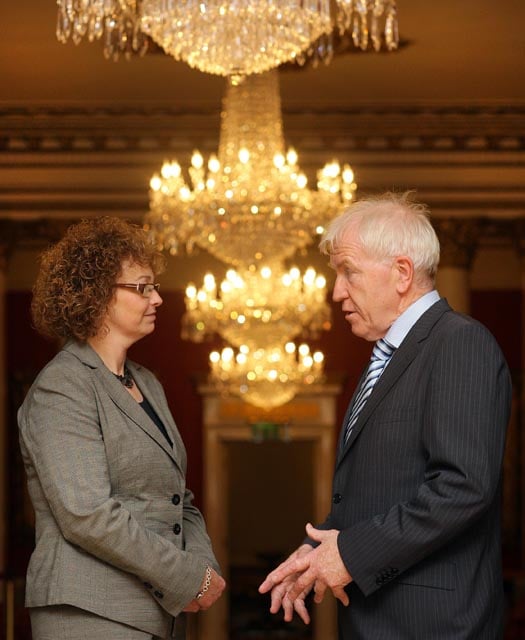
Carál Ní Chuilín Minister for Culture, Arts and Leisure in the Northern Assembly and Jimmy Deenihan TD Minister for Arts, Heritage and the Gaeltacht pictured speaking at the 4th Interregional meeting of the Waterways forward group at Dublin Castle last night Photo: Marc O'Sullivan

Department of Culture, Arts and Leisure Minister, Carál Ní Chuilín, said: "Ireland has some of the most impressive waterways on offer. From the Grand Canal in Dublin to Lough Erne in Enniskillen, Inland waterways have the potential to better connect the economic structures on this island. In the current economic climate such connections can only impact positively on increasing the contribution made by this sector to the all-island economy. The diversity of our waterways and the work being carried out by Waterways Ireland will not fail to impress. This conference will allow Waterways Ireland to plan in a strategic way for future investment in the waterways to improve their navigational, recreation and tourism potential for the benefit of all waterway users."

The Masterclasses will address issues around the sustainable development of inland waterways and the potential impact of climate change on regional inland waterways across Europe.

Lead by the Dutch Recreational Waterways Foundation, the INTERREG IVC Project runs from January 2010 to December 2012 and has a total budget of just over €2.8 million. The Masterclasses are one of a series of meetings, conferences and research projects being undertaken by the partners with the aim of sharing best practice, developing integrated, tailor made governance structures & models and facilitating increased cooperation at EU level.

Published in Inland Waterways

Dublin Bay

Dublin Bay on the east coast of Ireland stretches over seven kilometres, from Howth Head on its northern tip to Dalkey Island in the south. It's a place most Dubliners simply take for granted, and one of the capital's least visited places. But there's more going on out there than you'd imagine.

The biggest boating centre is at Dun Laoghaire Harbour on the Bay's south shore that is home to over 1,500 pleasure craft, four waterfront yacht clubs and Ireland's largest marina.

The bay is rather shallow with many sandbanks and rocky outcrops, and was notorious in the past for shipwrecks, especially when the wind was from the east. Until modern times, many ships and their passengers were lost along the treacherous coastline from Howth to Dun Laoghaire, less than a kilometre from shore.

The Bay is a C-shaped inlet of the Irish Sea and is about 10 kilometres wide along its north-south base, and 7 km in length to its apex at the centre of the city of Dublin; stretching from Howth Head in the north to Dalkey Point in the south. North Bull Island is situated in the northwest part of the bay, where one of two major inshore sandbanks lie, and features a 5 km long sandy beach, Dollymount Strand, fronting an internationally recognised wildfowl reserve. Many of the rivers of Dublin reach the Irish Sea at Dublin Bay: the River Liffey, with the River Dodder flow received less than 1 km inland, River Tolka, and various smaller rivers and streams.

Dublin Bay FAQs

There are approximately ten beaches and bathing spots around Dublin Bay: Dollymount Strand; Forty Foot Bathing Place; Half Moon bathing spot; Merrion Strand; Bull Wall; Sandycove Beach; Sandymount Strand; Seapoint; Shelley Banks; Sutton, Burrow Beach

There are slipways on the north side of Dublin Bay at Clontarf, Sutton and on the southside at Dun Laoghaire Harbour, and in Dalkey at Coliemore and Bulloch Harbours.

Dublin Bay is administered by a number of Government Departments, three local authorities and several statutory agencies. Dublin Port Company is in charge of navigation on the Bay.

Dublin Bay is approximately 70 sq kilometres or 7,000 hectares. The Bay is about 10 kilometres wide along its north-south base, and seven km in length east-west to its peak at the centre of the city of Dublin; stretching from Howth Head in the north to Dalkey Point in the south.

Dun Laoghaire Harbour on the southside of the Bay has an East and West Pier, each one kilometre long; this is one of the largest human-made harbours in the world. There also piers or walls at the entrance to the River Liffey at Dublin city known as the Great North and South Walls. Other harbours on the Bay include Bulloch Harbour and Coliemore Harbours both at Dalkey.

There are two marinas on Dublin Bay. Ireland's largest marina with over 800 berths is on the southern shore at Dun Laoghaire Harbour. The other is at Poolbeg Yacht and Boat Club on the River Liffey close to Dublin City.

Car and passenger Ferries operate from Dublin Port to the UK, Isle of Man and France. A passenger ferry operates from Dun Laoghaire Harbour to Howth as well as providing tourist voyages around the bay.

Dublin Bay has two Islands. Bull Island at Clontarf and Dalkey Island on the southern shore of the Bay.

The River Liffey flows through Dublin city and into the Bay. Its tributaries include the River Dodder, the River Poddle and the River Camac.

Dollymount, Burrow and Seapoint beaches

Approximately 1,500 boats from small dinghies to motorboats to ocean-going yachts. The vast majority, over 1,000, are moored at Dun Laoghaire Harbour which is Ireland's boating capital.

In 1981, UNESCO recognised the importance of Dublin Bay by designating North Bull Island as a Biosphere because of its rare and internationally important habitats and species of wildlife. To support sustainable development, UNESCO’s concept of a Biosphere has evolved to include not just areas of ecological value but also the areas around them and the communities that live and work within these areas. There have since been additional international and national designations, covering much of Dublin Bay, to ensure the protection of its water quality and biodiversity. To fulfil these broader management aims for the ecosystem, the Biosphere was expanded in 2015. The Biosphere now covers Dublin Bay, reflecting its significant environmental, economic, cultural and tourism importance, and extends to over 300km² to include the bay, the shore and nearby residential areas.

On the Southside at Dun Laoghaire, there is the National Yacht Club, Royal St. George Yacht Club, Royal Irish Yacht Club and Dun Laoghaire Motor Yacht Club as well as Dublin Bay Sailing Club. In the city centre, there is Poolbeg Yacht and Boat Club. On the Northside of Dublin, there is Clontarf Yacht and Boat Club and Sutton Dinghy Club. While not on Dublin Bay, Howth Yacht Club is the major north Dublin Sailing centre.

© Afloat 2020