Displaying items by tag: Paddy's Point
Looking to Build at Port of Cork, As 6,000 Car Storage Facility Is Explored Amid Surge in Imports
The possibility of building at the Port of Cork, a vast 6,000-space multi-storey storage compound for new cars imports is been explored, after it had to cope with a 60% surge in new cars that led to opening a new 'temporary' facility.
Typically, the port writes the Irish Examiner, receives approximately 5,000 trade cars at its Ringaskiddy (DWT) Deepwater Terminal in lower Cork Harbour in January, is expecting the arrival of more new vehicles estimated to be 8,000. The terminal Afloat adds is opposite of the berth for Brittany Ferries route to France which adjoins the Cork Container Terminal (CCT) which opened in 2022.
Existing infrastructure to store cars is at a facility also in Ringaskiddy which has reached capacity, however this has led to a port company decision to allocate a new storage facility for cars at Paddy’s Point, for the first time.
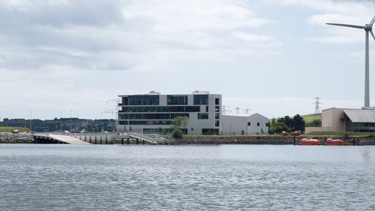
Paddy’s Point is located to the east of Ringaskiddy village, close to University College Cork’s Beaufort Research Laboratory which neighbours the campus of the National Maritime College of Ireland (NMCI).
According to the port which said today, “This temporary expansion is required to ensure the smooth and efficient handling of this substantial shipment”
At the weekend, the Port of Cork handled almost 3,000 cars, having arrived on two vehicle carrying-vessels from the Italian operator, Grimaldi Group, which Afloat reported of their separate Zeebrugge-Antwerp-Cork ro-ro freight feeder route launched in 2021 avoiding the UK land-bridge.
As for the combined vehicles on board, they ranged of Audi, Cupra, Seat, Skoda and Volkswagen models. Several companies are involved in importing to Cork, including OGMA, Euromed Ireland Logistics Ltd, National Vehicle Distribution, Mainport and the Doyle Shipping Group.
More from newspaper on the expansion of the vehicle trade sector.
New Paddy's Point Slipway is a Major Marine Leisure Boost in Cork Harbour
Afloat revisited the new public recreation area at Paddy's Point in Cork Harbour that was pictured from seaward in July. This month's trip permitted photographs of the new marine leisure facilities at Ringaskiddy from shoreside and they show the extent of the new purpose-built facility.
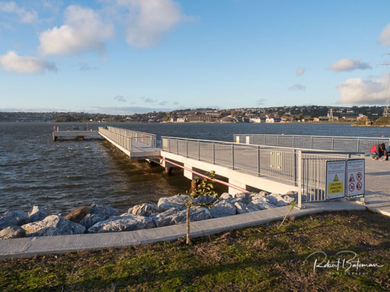
The pier and slipway, that opened in May 2019 is located adjacent to the Beaufort Building in Ringaskiddy and is managed and maintained by the Port of Cork.
The substantial new facilities replace the existing Ringaskiddy slipway and pier and were completed as part of the Cork container terminal development.
 (Above and below) Paddy's Point slipway - The highly useful pier and extra-wide slipway comprise concrete decks on concrete or tubular steel piles Photo: Bob Bateman
 The new Paddy’s Point Amenity Area is close to Gobby Beach and enhances recreation and amenity facilities in Cork Harbour. Photo: Bob Bateman
This new marine leisure facility is free for the public to use and includes a pontoon to launch leisure craft and a secure trailer park along with picnic benches in a landscaped area for all to enjoy.
 Even in Winter, the Paddy's Point slipway is in use, with a Cork Harbour windsurfer coming ashore
As regular Afloat readers will recall, these new facilities were primed for use as part of the National Laser championships being run in Cork Harbour back in August until Storm Ellen and Covid intervened. Such is the extent of these facilities, however, we're certain it won't be long before they're back in full use in boating season 2021.
 An amenity area adjacent to the pier provides parking and associated amenity facilities such as: new planting and landscaping, a new pedestrian circulation route and boat storage


New Cork Harbour Slipway & Pier Facility at Paddy's Point Includes Floating Pontoon & Gangway
The new public recreation area at Paddy's Point in Cork Harbour now has a new floating pontoon added to the existing marine leisure facilities at Ringaskiddy.
The pier and slipway, that opened in May 2019 is located adjacent to the Beaufort Building in Ringaskiddy and is managed and maintained by the Port of Cork.
The substantial new facilities replace the existing Ringaskiddy slipway and pier and were completed as part of the Cork container terminal development.
This new marine leisure facility is free for the public to use and includes a pontoon to launch leisure craft and a secure trailer park along with picnic benches in a landscaped area for all to enjoy.
 Paddy's Point new Marine Leisure facilties in Cork Harbour at Ringaskiddy Photo: Bob Bateman


