Displaying items by tag: Port or Cork
Heavy Transport Ship ‘Albatross’ Moves to Port of Cork’s Deepwater Berth for Ballasting
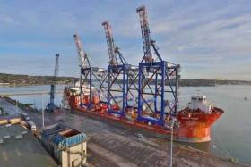
Three new, ship-to-shore container cranes manufactured in Ireland by Liebherr and assembled in Cork Harbour are scheduled for delivery to Crowley Puerto Rico Services’ Isla Grande Terminal in San Juan later this month.
As Afloat.ie previously reported, the cranes which are currently on board the Overseas Heavy Transport (OHT) vessel ‘Albatross’, transferred from Cork Dockyard to the Port of Cork’s Deepwater berth in Ringaskiddy to take on ballast before departure to San Juan. Each crane has a capacity of 65 tons and measure approximately 65 meters tall, with an outreach of 40 meters.
Ringaskiddy Deepwater Berth is capable of handling vessels of this size and providing a fast and efficient turnaround of such vessels. Before the ‘Albatross’ departs, it will share the berth with the weekly Maersk container service from Central America, bringing the overall length of both vessels alongside to 414 metres.
Speaking about the Port of Cork’s capabilities as a “Tier 1 port of national significance” and a naturally deep water port, Commercial Manager Captain Michael McCarthy said: The Port of Cork is delighted to partner with Liebherr Cranes in selecting our Ringaskiddy Deepwater port to export their cranes to World markets. We have had an excellent relationship with Liebherr since the early 1990’s when we commissioned two cranes for our facility in Ringaskiddy. Since then we have grown our relationship with the company and all our port cranes are manufactured by Liebherr.’
He continued: ‘It is great to see Liebherr recognising our exporting capability as a deep water port.’
While in Ringaskiddy the OHT vessel, which was originally designed as an oil tanker and converted to a crane carrier, will take on large volume of water ballast in the lower ballast tanks to counteract the weight of the cranes on deck. Each crane weighs approx. 900 tons; however the weight is evenly distributed on the main deck of the vessel. The cranes are then secured firmly (welded) to the deck of the vessel and as such they form a single composite unit.
According to John Hourihan Jr., Crowley’s senior vice president and general manager, Puerto Rico Services, the electric-powered cranes will be used to load and discharge containerized cargo being carried aboard Crowley’s two new liquefied natural gas (LNG)-powered, Commitment Class Con-Ro ships.
He said: “With these state-of-the-art cranes now erected, we are taking another step toward the transformation of our terminal into the most modern and efficient port facility on the island of Puerto Rico. We eagerly await their arrival here.”
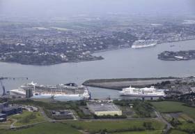
2015 was a very good year for the Port of Cork and subsidiaries. The combined traffic amounted to 11.02 million tonnes compared to 10.15 million tonnes in 2015 which represented an increase of 871,713 million tonnes or 8.6%. Container traffic at the Tivoli Container Terminal increased by a further 8% following a 13% increase in 2014, oil traffic increased by 21%, trade car imports increased by 48% and 56 cruise liners with a gross tonnage of 4 million tonnes, brought a record 144,000 passengers and crew to the region in 2015.
Turnover for the year 2015 amounted to €29.8 million up from €26.4 million in 2014. Consolidated Profit on ordinary activities before taxation amounted to €5.3 million compared to €2.7 million in 2014, an increase of €2.6 million.
Commenting on the 2015 annual results, Chief Executive Brendan Keating said: “Our annual results for 2015 are very encouraging and reflective of the capabilities of the Port to support growth in the Irish economy. We are hopeful that the upward trend will continue over the next three to four years.”
In 2015 the Port’s commitment to the development of infrastructure was supported by An Bord Pleanala by the granting of planning permission to the further development of Ringaskiddy port. The first phase of the Ringaskiddy Development includes an Optimised 360m Single Berth with supporting quay development and equipment. The project will be financed from cash reserves, EU CEF financial support, EIB funding and other bank loans.
Port of Cork Chairman John Mullins said: “For Ireland to achieve economic growth, it is critically important that the investment is made by the Port of Cork in port infrastructure. This investment will help consolidate the Port of Cork’s position as a key trade node in global supply chains, generating increased volumes of trade and increased levels of employment.”
In 2015 other highlights for the Ports were:
• The completion of the repayment of the 2009 docks rationalisation costs which reduced the Port of Cork cost base significantly.
• Completion of the investment of €1.5 million in upgraded, expanded and improved Cruise Berthing Facilities at the Cobh Deepwater Cruise Terminal to accommodate the maximum sized quantum class cruise vessels.
• Official notification by the European Commission of allocated funds of €12.74 million (17.5% of eligible expenditure) to the Ringaskiddy redevelopment project.
• Unveiling of Outline Plans for Phase 1 of the Bantry Inner Harbour Development costing in the region of €8.5 million, due to commence in Quarter 1 of 2016
Speaking about marine tourism in Ireland, Port of Cork Chairman John Mullins said: “Both the Ports of Cork and Bantry play key roles in the promotion of marine tourism. In 2015 Bantry Bay Port Company launched Ireland’s first Blueway initiative which has proven to be hugely popular with local and international visitors. In 2015 the Port of Cork welcomed 56 cruise liners to Cork Harbour bringing over 144,000 passengers and crew to the region.”
He continued: “Bantry Bay Port Company is beginning to position itself as a unique destination for smaller boutique cruises, with cruise calls set to rise in the coming years. Visiting cruise passengers make a huge contribution to the regional economy.”


