Menu

Ireland's sailing, boating & maritime magazine

Dublin Bay Boating News and Information

Displaying items by tag: Portglenone

Preparations are in full swing at the Glenone Coarse Angling Facility (known locally as Molloy’s Ford) at Portglenone in Co Antrim ahead of the world-renowned European Coarse Fishing Championships, set to take place on the Lower Bann later this month.

It will be the first time that Northern Ireland will host an angling event of this calibre since the World Championships were held on the River Erne in 1992, and the Newry Canal in 1982.

The National Coarse Fishing Federation of Ireland (NCFFI) was awarded the honour of hosting the 25th anniversary of this event by the Fédéracion International de la Pêche Sportive, and has been working closely with the local community to bring the event to this area of Mid Ulster.

The championships are set to be staged around the communities of Portglenone and Bellaghy in the Bann Corridor, an area of outstanding natural beauty where the teams representing 18 nations will be hosted throughout the event, bringing a welcome boost to the local economy.

Significant investment from Waterways Ireland and Mid Ulster District Council and the generosity of local landowners has led to the enhancement of the existing coarse fishing facility to support an angling event of this size.

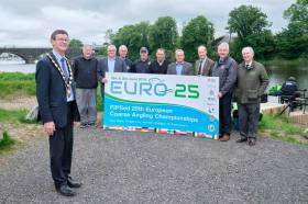
Chair of Mid Ulster District Council, Councillor Martin Kearney, expressed his delight in anticipation of the forthcoming championships.

“Preparations are almost complete to welcome over 100 anglers from countries all across Europe to the magnificent Lower Bann River at Portglenone-Bellaghy. The site has an established angling heritage as home of a number of large coarse angling festivals, including the annual Bann Bonanza, and our investment will create a River venue capable of hosting further international competitions in years to come.

“We would encourage the local community to come out to welcome the anglers in force at the Parade of Nations, a colourful affair which will see member of local community groups welcome the teams in procession as they make their way from Seamus Heaney Homeplace to the GAA Hall in Bellaghy on Thursday 27 June at 5.30pm.”

Sharon Lavin of Waterways Ireland said the cross-border body is “delighted to welcome so many international visitors to experience exceptional angling along the Lower Bann.

“They will undoubtedly enjoy the new facilities installed along the river at Portglenone and we look forward to working on other similar collaborative projects in the future, in continuing to develop and promote the excellent angling product available.”

Event organiser Jack Tisdall of the NCFFI said: “To host this prestigious event is fantastic news for the coarse angling community as we are providing Ireland with its first world-class angling facility on a river. Further planned developments will support the inclusivity of all in our sport and leave a legacy of angling for the area.”

Teams will train on the venue from Monday 23 to Friday 28 of June ahead of the Parade of Nations on Thursday 27 June where the chair of Mid Ulster District Council will ceremoniously receive the flags from the teams and the championships will be declared open by the president of FIPSed (Fédération Internationale de la Pêche Sportive en Eau Douce) on Saturday and Sunday 29-30 June.

Enthusiasts will be delighted with the opportunity to watch top rods in action on the bank, such as England’s Will Raison and Hungary’s Tamas Walter, as well as team Italy which is currently ranked number one in the world.

For more details of the European Coarse Fishing Championships, please visit the dedicated website HERE.

If you are a local community group who would like to take part in the Parade of Nations, contact Helen Rainsford, NCFFI public relations, on 07711 607 200.

The NCFFI is also appealing to members of all communities for their help in stewarding the event with 100 volunteers are required.

If you are available from 8am to 2pm on the Saturday and Sunday, or both, please visit the event website for more details and to register online.

Published in Angling

Dublin Bay

Dublin Bay on the east coast of Ireland stretches over seven kilometres, from Howth Head on its northern tip to Dalkey Island in the south. It's a place most Dubliners simply take for granted, and one of the capital's least visited places. But there's more going on out there than you'd imagine.

The biggest boating centre is at Dun Laoghaire Harbour on the Bay's south shore that is home to over 1,500 pleasure craft, four waterfront yacht clubs and Ireland's largest marina.

The bay is rather shallow with many sandbanks and rocky outcrops, and was notorious in the past for shipwrecks, especially when the wind was from the east. Until modern times, many ships and their passengers were lost along the treacherous coastline from Howth to Dun Laoghaire, less than a kilometre from shore.

The Bay is a C-shaped inlet of the Irish Sea and is about 10 kilometres wide along its north-south base, and 7 km in length to its apex at the centre of the city of Dublin; stretching from Howth Head in the north to Dalkey Point in the south. North Bull Island is situated in the northwest part of the bay, where one of two major inshore sandbanks lie, and features a 5 km long sandy beach, Dollymount Strand, fronting an internationally recognised wildfowl reserve. Many of the rivers of Dublin reach the Irish Sea at Dublin Bay: the River Liffey, with the River Dodder flow received less than 1 km inland, River Tolka, and various smaller rivers and streams.

Dublin Bay FAQs

There are approximately ten beaches and bathing spots around Dublin Bay: Dollymount Strand; Forty Foot Bathing Place; Half Moon bathing spot; Merrion Strand; Bull Wall; Sandycove Beach; Sandymount Strand; Seapoint; Shelley Banks; Sutton, Burrow Beach

There are slipways on the north side of Dublin Bay at Clontarf, Sutton and on the southside at Dun Laoghaire Harbour, and in Dalkey at Coliemore and Bulloch Harbours.

Dublin Bay is administered by a number of Government Departments, three local authorities and several statutory agencies. Dublin Port Company is in charge of navigation on the Bay.

Dublin Bay is approximately 70 sq kilometres or 7,000 hectares. The Bay is about 10 kilometres wide along its north-south base, and seven km in length east-west to its peak at the centre of the city of Dublin; stretching from Howth Head in the north to Dalkey Point in the south.

Dun Laoghaire Harbour on the southside of the Bay has an East and West Pier, each one kilometre long; this is one of the largest human-made harbours in the world. There also piers or walls at the entrance to the River Liffey at Dublin city known as the Great North and South Walls. Other harbours on the Bay include Bulloch Harbour and Coliemore Harbours both at Dalkey.

There are two marinas on Dublin Bay. Ireland's largest marina with over 800 berths is on the southern shore at Dun Laoghaire Harbour. The other is at Poolbeg Yacht and Boat Club on the River Liffey close to Dublin City.

Car and passenger Ferries operate from Dublin Port to the UK, Isle of Man and France. A passenger ferry operates from Dun Laoghaire Harbour to Howth as well as providing tourist voyages around the bay.

Dublin Bay has two Islands. Bull Island at Clontarf and Dalkey Island on the southern shore of the Bay.

The River Liffey flows through Dublin city and into the Bay. Its tributaries include the River Dodder, the River Poddle and the River Camac.

Dollymount, Burrow and Seapoint beaches

Approximately 1,500 boats from small dinghies to motorboats to ocean-going yachts. The vast majority, over 1,000, are moored at Dun Laoghaire Harbour which is Ireland's boating capital.

In 1981, UNESCO recognised the importance of Dublin Bay by designating North Bull Island as a Biosphere because of its rare and internationally important habitats and species of wildlife. To support sustainable development, UNESCO’s concept of a Biosphere has evolved to include not just areas of ecological value but also the areas around them and the communities that live and work within these areas. There have since been additional international and national designations, covering much of Dublin Bay, to ensure the protection of its water quality and biodiversity. To fulfil these broader management aims for the ecosystem, the Biosphere was expanded in 2015. The Biosphere now covers Dublin Bay, reflecting its significant environmental, economic, cultural and tourism importance, and extends to over 300km² to include the bay, the shore and nearby residential areas.

On the Southside at Dun Laoghaire, there is the National Yacht Club, Royal St. George Yacht Club, Royal Irish Yacht Club and Dun Laoghaire Motor Yacht Club as well as Dublin Bay Sailing Club. In the city centre, there is Poolbeg Yacht and Boat Club. On the Northside of Dublin, there is Clontarf Yacht and Boat Club and Sutton Dinghy Club. While not on Dublin Bay, Howth Yacht Club is the major north Dublin Sailing centre.

© Afloat 2020