Menu

Ireland's sailing, boating & maritime magazine

Dublin Bay Boating News and Information

Displaying items by tag: River Explorers

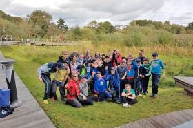
Waterways Ireland and Leave No Trace Ireland are working in partnership again to deliver their River Explorers programme.

River Explorers engages local primary school children to take pride in their local river, lake or canal.

Funding was successfully secured during 2018 to run the programme from a number of local authorities including Cavan, Longford, Fingal, Kilkenny, Limerick and Clare.

The programme runs throughout February and March, and for 2019 increases from 17 to 20 days given the additional level of funding secured.

The programme will be taking place at the 12th Lock in Castleknock and Richmond Harbour, Clondra on the Royal Canal; Twomilegate on the Shannon; Ballyconnell on the Shannon-Erne Waterway; and Graiguenamanagh on the Barrow.

Waterways Ireland says schools have been “very eager” to participate in the programme, with all available sessions now fully booked.

River Explorers is a one-day programme which aims to enable participants to become aware of the geographical location, leisure potential and biodiversity value of their local river, lake or canal through outdoor and hands-on learning, skills training, resource development and raising public awareness.

“Creating positive memories, healthy lifestyles, and physical wellbeing as well as paving the way for creating opportunities for caring for our natural heritage are all integral facets of a project that has sustainability at its core,” says Waterways Ireland.

“This project will empower primary school students to connect with their natural environment and enjoy their natural heritage responsibly and ethically.”

Each participating school group will take part in classroom-based sessions in the morning followed by outdoor sessions in the afternoon at their local waterway.

“The idea in the morning session is to impart the knowledge and skills the participants need to understand how to identify the wealth of biodiversity on the local rivers and canals, be able to anticipate how their use of these waterways impacts on this and the measures they can take to minimise this impact,” the organisers explain.

“The afternoon session is about putting the knowledge and skills learned in the classroom into practice. Students will have the opportunity to discover the vast array of wildlife that calls the inland waterways their home.

“Each group will learn how to identify some of the plants and trees along canal and river banks and even come face to face with some mini-beasts living in these ecosystems.

“Leave No Trace Ireland and Waterways Ireland are delighted to partner in the delivery of what promises to be an excellent education programme.”

Published in Inland Waterways

Dublin Bay

Dublin Bay on the east coast of Ireland stretches over seven kilometres, from Howth Head on its northern tip to Dalkey Island in the south. It's a place most Dubliners simply take for granted, and one of the capital's least visited places. But there's more going on out there than you'd imagine.

The biggest boating centre is at Dun Laoghaire Harbour on the Bay's south shore that is home to over 1,500 pleasure craft, four waterfront yacht clubs and Ireland's largest marina.

The bay is rather shallow with many sandbanks and rocky outcrops, and was notorious in the past for shipwrecks, especially when the wind was from the east. Until modern times, many ships and their passengers were lost along the treacherous coastline from Howth to Dun Laoghaire, less than a kilometre from shore.

The Bay is a C-shaped inlet of the Irish Sea and is about 10 kilometres wide along its north-south base, and 7 km in length to its apex at the centre of the city of Dublin; stretching from Howth Head in the north to Dalkey Point in the south. North Bull Island is situated in the northwest part of the bay, where one of two major inshore sandbanks lie, and features a 5 km long sandy beach, Dollymount Strand, fronting an internationally recognised wildfowl reserve. Many of the rivers of Dublin reach the Irish Sea at Dublin Bay: the River Liffey, with the River Dodder flow received less than 1 km inland, River Tolka, and various smaller rivers and streams.

Dublin Bay FAQs

There are approximately ten beaches and bathing spots around Dublin Bay: Dollymount Strand; Forty Foot Bathing Place; Half Moon bathing spot; Merrion Strand; Bull Wall; Sandycove Beach; Sandymount Strand; Seapoint; Shelley Banks; Sutton, Burrow Beach

There are slipways on the north side of Dublin Bay at Clontarf, Sutton and on the southside at Dun Laoghaire Harbour, and in Dalkey at Coliemore and Bulloch Harbours.

Dublin Bay is administered by a number of Government Departments, three local authorities and several statutory agencies. Dublin Port Company is in charge of navigation on the Bay.

Dublin Bay is approximately 70 sq kilometres or 7,000 hectares. The Bay is about 10 kilometres wide along its north-south base, and seven km in length east-west to its peak at the centre of the city of Dublin; stretching from Howth Head in the north to Dalkey Point in the south.

Dun Laoghaire Harbour on the southside of the Bay has an East and West Pier, each one kilometre long; this is one of the largest human-made harbours in the world. There also piers or walls at the entrance to the River Liffey at Dublin city known as the Great North and South Walls. Other harbours on the Bay include Bulloch Harbour and Coliemore Harbours both at Dalkey.

There are two marinas on Dublin Bay. Ireland's largest marina with over 800 berths is on the southern shore at Dun Laoghaire Harbour. The other is at Poolbeg Yacht and Boat Club on the River Liffey close to Dublin City.

Car and passenger Ferries operate from Dublin Port to the UK, Isle of Man and France. A passenger ferry operates from Dun Laoghaire Harbour to Howth as well as providing tourist voyages around the bay.

Dublin Bay has two Islands. Bull Island at Clontarf and Dalkey Island on the southern shore of the Bay.

The River Liffey flows through Dublin city and into the Bay. Its tributaries include the River Dodder, the River Poddle and the River Camac.

Dollymount, Burrow and Seapoint beaches

Approximately 1,500 boats from small dinghies to motorboats to ocean-going yachts. The vast majority, over 1,000, are moored at Dun Laoghaire Harbour which is Ireland's boating capital.

In 1981, UNESCO recognised the importance of Dublin Bay by designating North Bull Island as a Biosphere because of its rare and internationally important habitats and species of wildlife. To support sustainable development, UNESCO’s concept of a Biosphere has evolved to include not just areas of ecological value but also the areas around them and the communities that live and work within these areas. There have since been additional international and national designations, covering much of Dublin Bay, to ensure the protection of its water quality and biodiversity. To fulfil these broader management aims for the ecosystem, the Biosphere was expanded in 2015. The Biosphere now covers Dublin Bay, reflecting its significant environmental, economic, cultural and tourism importance, and extends to over 300km² to include the bay, the shore and nearby residential areas.

On the Southside at Dun Laoghaire, there is the National Yacht Club, Royal St. George Yacht Club, Royal Irish Yacht Club and Dun Laoghaire Motor Yacht Club as well as Dublin Bay Sailing Club. In the city centre, there is Poolbeg Yacht and Boat Club. On the Northside of Dublin, there is Clontarf Yacht and Boat Club and Sutton Dinghy Club. While not on Dublin Bay, Howth Yacht Club is the major north Dublin Sailing centre.

© Afloat 2020