Menu

Ireland's sailing, boating & maritime magazine

Dublin Bay Boating News and Information

Displaying items by tag: River Lackagh

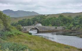
#Angling - Sean Kyne TD, Minister of State with responsibility for Inland Fisheries, has officially opened a new fish counter facility in the designated spring salmon fishery on the River Lackagh.

The project, which was devised and delivered by Inland Fisheries Ireland, was completed in recent months and will provide important data for the future management of spring salmon, grilse and sea trout stocks for the River Lackagh catchment, which incorporates Lough Beagh, situated in Glenveagh National Park.

This major infrastructural project, which was funded under IFI’s Salmon Conservation Fund, includes installation of a crump weir, Logie fish counter and access road to the Lackagh River at Creeslough, Co Donegal.

The counter will provide verifiable, accurate data on the size, duration and timing of fish migration through the fishery.

The River Lackagh counter project was developed by IFI in response to closure of the River Lackagh salmon fishery in 2007, when scientific advice indicated that salmon stocks had fallen to below their conservation limit.

The salmon fishery remained closed to enable fish stocks re-build until 2013 when electrofishing surveys confirmed that juvenile salmon stocks had recovered sufficiently to allow for the re-opening of the salmon fishery on a ‘catch and release’ basis.

IFI says the new counter will be a valuable addition to its national suite of index counters and represents the organisation’s first counter on the north Donegal coast.

Minister Kyne said he is “delighted to officially open this fish counter which will help protect fish stocks in the area. Angling is a valuable asset to local communities here in Donegal. This development will help us ensure the sustainability of fish populations for future generations.”

IFI chief executive added: “This fish counter provides real time data on fish stocks in the fishery and allows us to adapt to changing stock levels. This is crucial both from a conservation and economic viewpoint as this fishery contains valuable wild fish populations.

“I would like to acknowledge all our partners in this project who recognised the importance of this project and worked with us to delivery this facility for the local area.”

Angling in Ireland currently contributes €836 million to the Irish economy annually, supporting upwards of 11,000 jobs which are often in rural and peripheral communities.

IFI’s National Strategy for Angling Development aims to ensure the sustainable development of the natural angling resource in a conservation focused manner. If realised, the strategy could help increase the economic contribution of angling by €53 million annually and support 18,000 jobs.

IFI collaborated with several partners on the River Lackagh project including Donegal County Council, the National Parks and Wildlife Service (NPWS) and ESB Networks. IFI also acknowledges the assistance of Creeslough & District Angling Association, owners Hillary Keegan and John Coyle and service providers WD Buchanan & Co Ltd, H Harkin Plan Hire Ltd and Source Civil Ltd.

Published in Angling

Dublin Bay

Dublin Bay on the east coast of Ireland stretches over seven kilometres, from Howth Head on its northern tip to Dalkey Island in the south. It's a place most Dubliners simply take for granted, and one of the capital's least visited places. But there's more going on out there than you'd imagine.

The biggest boating centre is at Dun Laoghaire Harbour on the Bay's south shore that is home to over 1,500 pleasure craft, four waterfront yacht clubs and Ireland's largest marina.

The bay is rather shallow with many sandbanks and rocky outcrops, and was notorious in the past for shipwrecks, especially when the wind was from the east. Until modern times, many ships and their passengers were lost along the treacherous coastline from Howth to Dun Laoghaire, less than a kilometre from shore.

The Bay is a C-shaped inlet of the Irish Sea and is about 10 kilometres wide along its north-south base, and 7 km in length to its apex at the centre of the city of Dublin; stretching from Howth Head in the north to Dalkey Point in the south. North Bull Island is situated in the northwest part of the bay, where one of two major inshore sandbanks lie, and features a 5 km long sandy beach, Dollymount Strand, fronting an internationally recognised wildfowl reserve. Many of the rivers of Dublin reach the Irish Sea at Dublin Bay: the River Liffey, with the River Dodder flow received less than 1 km inland, River Tolka, and various smaller rivers and streams.

Dublin Bay FAQs

There are approximately ten beaches and bathing spots around Dublin Bay: Dollymount Strand; Forty Foot Bathing Place; Half Moon bathing spot; Merrion Strand; Bull Wall; Sandycove Beach; Sandymount Strand; Seapoint; Shelley Banks; Sutton, Burrow Beach

There are slipways on the north side of Dublin Bay at Clontarf, Sutton and on the southside at Dun Laoghaire Harbour, and in Dalkey at Coliemore and Bulloch Harbours.

Dublin Bay is administered by a number of Government Departments, three local authorities and several statutory agencies. Dublin Port Company is in charge of navigation on the Bay.

Dublin Bay is approximately 70 sq kilometres or 7,000 hectares. The Bay is about 10 kilometres wide along its north-south base, and seven km in length east-west to its peak at the centre of the city of Dublin; stretching from Howth Head in the north to Dalkey Point in the south.

Dun Laoghaire Harbour on the southside of the Bay has an East and West Pier, each one kilometre long; this is one of the largest human-made harbours in the world. There also piers or walls at the entrance to the River Liffey at Dublin city known as the Great North and South Walls. Other harbours on the Bay include Bulloch Harbour and Coliemore Harbours both at Dalkey.

There are two marinas on Dublin Bay. Ireland's largest marina with over 800 berths is on the southern shore at Dun Laoghaire Harbour. The other is at Poolbeg Yacht and Boat Club on the River Liffey close to Dublin City.

Car and passenger Ferries operate from Dublin Port to the UK, Isle of Man and France. A passenger ferry operates from Dun Laoghaire Harbour to Howth as well as providing tourist voyages around the bay.

Dublin Bay has two Islands. Bull Island at Clontarf and Dalkey Island on the southern shore of the Bay.

The River Liffey flows through Dublin city and into the Bay. Its tributaries include the River Dodder, the River Poddle and the River Camac.

Dollymount, Burrow and Seapoint beaches

Approximately 1,500 boats from small dinghies to motorboats to ocean-going yachts. The vast majority, over 1,000, are moored at Dun Laoghaire Harbour which is Ireland's boating capital.

In 1981, UNESCO recognised the importance of Dublin Bay by designating North Bull Island as a Biosphere because of its rare and internationally important habitats and species of wildlife. To support sustainable development, UNESCO’s concept of a Biosphere has evolved to include not just areas of ecological value but also the areas around them and the communities that live and work within these areas. There have since been additional international and national designations, covering much of Dublin Bay, to ensure the protection of its water quality and biodiversity. To fulfil these broader management aims for the ecosystem, the Biosphere was expanded in 2015. The Biosphere now covers Dublin Bay, reflecting its significant environmental, economic, cultural and tourism importance, and extends to over 300km² to include the bay, the shore and nearby residential areas.

On the Southside at Dun Laoghaire, there is the National Yacht Club, Royal St. George Yacht Club, Royal Irish Yacht Club and Dun Laoghaire Motor Yacht Club as well as Dublin Bay Sailing Club. In the city centre, there is Poolbeg Yacht and Boat Club. On the Northside of Dublin, there is Clontarf Yacht and Boat Club and Sutton Dinghy Club. While not on Dublin Bay, Howth Yacht Club is the major north Dublin Sailing centre.

© Afloat 2020