Menu

Ireland's sailing, boating & maritime magazine

Dublin Bay Boating News and Information

Displaying items by tag: Rivers Suir

#thisislandnation – After an absence of several years it is a pleasure to return to the airwaves, a decision I have taken in pursuance of my belief that the national media is seriously neglectful of maritime matters. The marine sphere is not adequately served by the national media, print or broadcast. The specialist media such as AFLOAT and community radio offers an alternative voice, so do social media outlets.

THIS ISLAND NATION is a monthly hour-long radio programme of which the first edition available here on Afloat.ie highlights the decay forced upon coastal communities by government and EU policies.

Sean Doherty, who I interviewed for my programme at the 'EMPOWERING COASTAL COMMUNITIES' Conference in County Waterford, is a man who is trying to preserve his local community at Cheekpoint on the Waterford Estuary. He describes how the ending of the drift net fishery, followed by the closure of the eel fishery, has contributed to what he sees as the destruction of his community. Men earned a living from the fisheries for their families, others were employed to maintain engines on the boats, more had work repairing the fishing boats and local restaurants served their catches as local produce. But these aspects of life in Cheekpoint no longer exist. The village has suffered heavily. His interview indicates how decisions were made by politicians and State administrators without carrying out any examination of the social effects and the damage they would cause to the communities affected. Those communities were treated with disregard and what amounts to contempt for their future. It is a sombre story.

The oceans are, in places, a wilderness, sweeping the globe and washing the edges of our cities. They provide opportunity and potential. The coastal communities are the first interface of Ireland with the sea at the coastal rim of this island nation.

So why is it that the sea is not regarded as a priority national interest?

The answer lies in a failure of political and economic perception, fuelled by an adherence to globalisation rather than pride in being an island nation.

Ireland is the most western island nation in Europe, but there is no pride evident in Government circles that we Irish are islanders. At the highest level of political life and civil service administration, as well as amongst the national media and the general public, there is a failure of perception to realise that being islanders gives Irish people an unique place in Europe. The concept of globalisation, which policies favour, is the destruction of uniqueness.

As Sean Doherty says in the interview, there are publicly expressed concerns and movements calling for the protection of indigenous communities around the world; and for the promotion of multi-culturalism in Ireland; but there is little or no interest and no movements for the preservation of the indigenous people of Ireland –the coastal and fishing communities.

The voice of the sea can speak to the soul, that voice should be heard by those who make the decisions which affect Ireland.

While there are some positive steps, which are also outlined in the programme - THIS ISLAND NATION - which you can hear on this website, these are not enough to counterbalance neglect of the maritime sphere. More is needed.

Cheekpoint nestles in the Waterford Estuary near where the Rivers Suir and Barrow meet, lying beneath Minaun Hill and has a magnificent, panoramic view across Waterford Harbour.

Sean Doherty described himself to me as an angry, frustrated man at what he sees as he looks out from his home on the estuary, "because what I am seeing is destruction caused by a form of blindness."

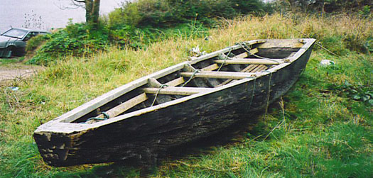
The Prong is the local boat which has been used by fishermen from the village. The first one built in many years is pictured below, together with an example of an older boat. The coastal communities are endeavouring to maintain their maritime heritage. So should the nation.

JOHNGOSSIPCHEEKPOINTPRONG

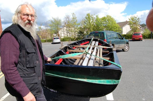
Above John Gossip with the new Cheekpoint Prong and below an older example of the craft

OLDER EXAMPLEOFCHEEKPOINTPRONG


Twitter: @TomMacSweeney

Published in Island Nation

Dublin Bay

Dublin Bay on the east coast of Ireland stretches over seven kilometres, from Howth Head on its northern tip to Dalkey Island in the south. It's a place most Dubliners simply take for granted, and one of the capital's least visited places. But there's more going on out there than you'd imagine.

The biggest boating centre is at Dun Laoghaire Harbour on the Bay's south shore that is home to over 1,500 pleasure craft, four waterfront yacht clubs and Ireland's largest marina.

The bay is rather shallow with many sandbanks and rocky outcrops, and was notorious in the past for shipwrecks, especially when the wind was from the east. Until modern times, many ships and their passengers were lost along the treacherous coastline from Howth to Dun Laoghaire, less than a kilometre from shore.

The Bay is a C-shaped inlet of the Irish Sea and is about 10 kilometres wide along its north-south base, and 7 km in length to its apex at the centre of the city of Dublin; stretching from Howth Head in the north to Dalkey Point in the south. North Bull Island is situated in the northwest part of the bay, where one of two major inshore sandbanks lie, and features a 5 km long sandy beach, Dollymount Strand, fronting an internationally recognised wildfowl reserve. Many of the rivers of Dublin reach the Irish Sea at Dublin Bay: the River Liffey, with the River Dodder flow received less than 1 km inland, River Tolka, and various smaller rivers and streams.

Dublin Bay FAQs

There are approximately ten beaches and bathing spots around Dublin Bay: Dollymount Strand; Forty Foot Bathing Place; Half Moon bathing spot; Merrion Strand; Bull Wall; Sandycove Beach; Sandymount Strand; Seapoint; Shelley Banks; Sutton, Burrow Beach

There are slipways on the north side of Dublin Bay at Clontarf, Sutton and on the southside at Dun Laoghaire Harbour, and in Dalkey at Coliemore and Bulloch Harbours.

Dublin Bay is administered by a number of Government Departments, three local authorities and several statutory agencies. Dublin Port Company is in charge of navigation on the Bay.

Dublin Bay is approximately 70 sq kilometres or 7,000 hectares. The Bay is about 10 kilometres wide along its north-south base, and seven km in length east-west to its peak at the centre of the city of Dublin; stretching from Howth Head in the north to Dalkey Point in the south.

Dun Laoghaire Harbour on the southside of the Bay has an East and West Pier, each one kilometre long; this is one of the largest human-made harbours in the world. There also piers or walls at the entrance to the River Liffey at Dublin city known as the Great North and South Walls. Other harbours on the Bay include Bulloch Harbour and Coliemore Harbours both at Dalkey.

There are two marinas on Dublin Bay. Ireland's largest marina with over 800 berths is on the southern shore at Dun Laoghaire Harbour. The other is at Poolbeg Yacht and Boat Club on the River Liffey close to Dublin City.

Car and passenger Ferries operate from Dublin Port to the UK, Isle of Man and France. A passenger ferry operates from Dun Laoghaire Harbour to Howth as well as providing tourist voyages around the bay.

Dublin Bay has two Islands. Bull Island at Clontarf and Dalkey Island on the southern shore of the Bay.

The River Liffey flows through Dublin city and into the Bay. Its tributaries include the River Dodder, the River Poddle and the River Camac.

Dollymount, Burrow and Seapoint beaches

Approximately 1,500 boats from small dinghies to motorboats to ocean-going yachts. The vast majority, over 1,000, are moored at Dun Laoghaire Harbour which is Ireland's boating capital.

In 1981, UNESCO recognised the importance of Dublin Bay by designating North Bull Island as a Biosphere because of its rare and internationally important habitats and species of wildlife. To support sustainable development, UNESCO’s concept of a Biosphere has evolved to include not just areas of ecological value but also the areas around them and the communities that live and work within these areas. There have since been additional international and national designations, covering much of Dublin Bay, to ensure the protection of its water quality and biodiversity. To fulfil these broader management aims for the ecosystem, the Biosphere was expanded in 2015. The Biosphere now covers Dublin Bay, reflecting its significant environmental, economic, cultural and tourism importance, and extends to over 300km² to include the bay, the shore and nearby residential areas.

On the Southside at Dun Laoghaire, there is the National Yacht Club, Royal St. George Yacht Club, Royal Irish Yacht Club and Dun Laoghaire Motor Yacht Club as well as Dublin Bay Sailing Club. In the city centre, there is Poolbeg Yacht and Boat Club. On the Northside of Dublin, there is Clontarf Yacht and Boat Club and Sutton Dinghy Club. While not on Dublin Bay, Howth Yacht Club is the major north Dublin Sailing centre.

© Afloat 2020