Menu

Ireland's sailing, boating & maritime magazine

Dublin Bay Boating News and Information

Displaying items by tag: Rolt

Nenagh resident and inland waterways enthusiast, Nick Theato, single-handed aboard 'Bo-Bo, a five metre Pedro trailer/sailer and Pat Kelly, Killadangan, with his son Andrew in 'Shu-Ra-Nu', a 6 metre Etap 20 trailer/sailer, plan to raise funds for Lifeboats Ireland by undertaking the IWAI Green & Silver Challenge in June, 2011. Their fundraising target is €5,000.00.

On the 25th June, 1946, Tom and Angela Rolt left Athlone aboard 'Le Coq', a 28ft.x8ft. converted ship's lifeboat on a voyage that would inspire contemporary and successive generations of inland waterways enthusiasts.

Tom Rolt wonderfully documented the voyage in his book 'Green & Silver', published in 1949, which has since become a classic. This work was instrumental in inspiring the small group who founded the Inland Waterways Association of Ireland in 1954, whose objective was to save the Shannon navigation from strangulation by low bridges. Indeed, the colour scheme of the IWAI's logo and burgee derive from the cover design of Rolt's book.

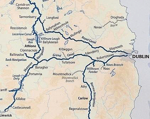
With the re-opening of the Royal Canal in October 2010, it is now possible to retrace Rolt's journey in full and complete the circular route formed by the Royal Canal, River Liffey, Grand Canal, River Shannon and Camlin River.

To celebrate this event, the IWAI has initiated the 'Green & Silver Challenge' in an effort to encourage people to make the circular journey. Nenagh resident, Nick Theato single-handed aboard 'Bo-Bo, a 16 foot Pedro trailer/sailer and Pat Kelly, Killadangan, with his son Andrew aboard 'Shu-Ra-Nu', a 20 foot Etap trailer/sailer, plan to raise funds for Lifeboats Ireland by travelling the full Green & Silver Route throughout June 2011.

Departing on June 1st, they will travel from Dromineer through Lough Derg and Lough Ree and enter the Royal Canal at Richmond Harbour. They plan to cross the Liffey in Dublin 17 days later, where they will take a welcome day off before commencing the return journey via the Grand Canal to Shannon Harbour. The journey will take approximately 28 days, will cover a minimum of 333 km. and navigate through 92 locks (some double), 91 of which are manual. Their fundraising target is €5,000

inland_waterways_Green_Silver

Nick Theato is Treasurer of the Lough Derg RNLI Fundraising Branch and Lough Derg Lifeboat Station at Dromineer.

Pat Kelly is Secretary of the Lough Derg RNLI Fundraising Branch.

Nick and Pat welcome all sponsorship, however modest. Contributions can be pledged online at http://www.mycharity.ie/event/green_silver_event/. Nick may be contacted on 086 1738014 ([email protected]). Pat is at 087 6908099 ([email protected]).

For further details / interviews / photos: Contact Pat Kelly at 087 6908099 ([email protected]). Support photography: Gerardine Wisdom 087 6522582 ([email protected]).

Published in Inland Waterways

Dublin Bay

Dublin Bay on the east coast of Ireland stretches over seven kilometres, from Howth Head on its northern tip to Dalkey Island in the south. It's a place most Dubliners simply take for granted, and one of the capital's least visited places. But there's more going on out there than you'd imagine.

The biggest boating centre is at Dun Laoghaire Harbour on the Bay's south shore that is home to over 1,500 pleasure craft, four waterfront yacht clubs and Ireland's largest marina.

The bay is rather shallow with many sandbanks and rocky outcrops, and was notorious in the past for shipwrecks, especially when the wind was from the east. Until modern times, many ships and their passengers were lost along the treacherous coastline from Howth to Dun Laoghaire, less than a kilometre from shore.

The Bay is a C-shaped inlet of the Irish Sea and is about 10 kilometres wide along its north-south base, and 7 km in length to its apex at the centre of the city of Dublin; stretching from Howth Head in the north to Dalkey Point in the south. North Bull Island is situated in the northwest part of the bay, where one of two major inshore sandbanks lie, and features a 5 km long sandy beach, Dollymount Strand, fronting an internationally recognised wildfowl reserve. Many of the rivers of Dublin reach the Irish Sea at Dublin Bay: the River Liffey, with the River Dodder flow received less than 1 km inland, River Tolka, and various smaller rivers and streams.

Dublin Bay FAQs

There are approximately ten beaches and bathing spots around Dublin Bay: Dollymount Strand; Forty Foot Bathing Place; Half Moon bathing spot; Merrion Strand; Bull Wall; Sandycove Beach; Sandymount Strand; Seapoint; Shelley Banks; Sutton, Burrow Beach

There are slipways on the north side of Dublin Bay at Clontarf, Sutton and on the southside at Dun Laoghaire Harbour, and in Dalkey at Coliemore and Bulloch Harbours.

Dublin Bay is administered by a number of Government Departments, three local authorities and several statutory agencies. Dublin Port Company is in charge of navigation on the Bay.

Dublin Bay is approximately 70 sq kilometres or 7,000 hectares. The Bay is about 10 kilometres wide along its north-south base, and seven km in length east-west to its peak at the centre of the city of Dublin; stretching from Howth Head in the north to Dalkey Point in the south.

Dun Laoghaire Harbour on the southside of the Bay has an East and West Pier, each one kilometre long; this is one of the largest human-made harbours in the world. There also piers or walls at the entrance to the River Liffey at Dublin city known as the Great North and South Walls. Other harbours on the Bay include Bulloch Harbour and Coliemore Harbours both at Dalkey.

There are two marinas on Dublin Bay. Ireland's largest marina with over 800 berths is on the southern shore at Dun Laoghaire Harbour. The other is at Poolbeg Yacht and Boat Club on the River Liffey close to Dublin City.

Car and passenger Ferries operate from Dublin Port to the UK, Isle of Man and France. A passenger ferry operates from Dun Laoghaire Harbour to Howth as well as providing tourist voyages around the bay.

Dublin Bay has two Islands. Bull Island at Clontarf and Dalkey Island on the southern shore of the Bay.

The River Liffey flows through Dublin city and into the Bay. Its tributaries include the River Dodder, the River Poddle and the River Camac.

Dollymount, Burrow and Seapoint beaches

Approximately 1,500 boats from small dinghies to motorboats to ocean-going yachts. The vast majority, over 1,000, are moored at Dun Laoghaire Harbour which is Ireland's boating capital.

In 1981, UNESCO recognised the importance of Dublin Bay by designating North Bull Island as a Biosphere because of its rare and internationally important habitats and species of wildlife. To support sustainable development, UNESCO’s concept of a Biosphere has evolved to include not just areas of ecological value but also the areas around them and the communities that live and work within these areas. There have since been additional international and national designations, covering much of Dublin Bay, to ensure the protection of its water quality and biodiversity. To fulfil these broader management aims for the ecosystem, the Biosphere was expanded in 2015. The Biosphere now covers Dublin Bay, reflecting its significant environmental, economic, cultural and tourism importance, and extends to over 300km² to include the bay, the shore and nearby residential areas.

On the Southside at Dun Laoghaire, there is the National Yacht Club, Royal St. George Yacht Club, Royal Irish Yacht Club and Dun Laoghaire Motor Yacht Club as well as Dublin Bay Sailing Club. In the city centre, there is Poolbeg Yacht and Boat Club. On the Northside of Dublin, there is Clontarf Yacht and Boat Club and Sutton Dinghy Club. While not on Dublin Bay, Howth Yacht Club is the major north Dublin Sailing centre.

© Afloat 2020