Menu

Ireland's sailing, boating & maritime magazine

Dublin Bay Boating News and Information

Displaying items by tag: Ros a Mhil

Galway County Council has refused to extend planning permission for a new quay at Ros a Mhíl, as work had yet to begin on the multi-million euro harbour project.

The Department of Agriculture, Food & The Marine received approval for a new deep water quay at the Ros a Mhíl Fishery Harbour Centre back in 2018.

The current planning permission is not due to expire until April of 2023, but the Department is already seeking a five year extension of that approval.

In the application submitted in April, it was stated that work was due to begin in May, with an estimated completion date of July 2024.

The requirement for ‘substantial works’ to have been carried out in order to grant an EOD comes under new planning regulations which came into force last September.

This is not a major setback for the project, as with work expected to commence this summer, there will still be time to submit another Extension of Duration application later this year, or in early 2023.

Galway Daily has more on the story. 

Published in Irish Harbours

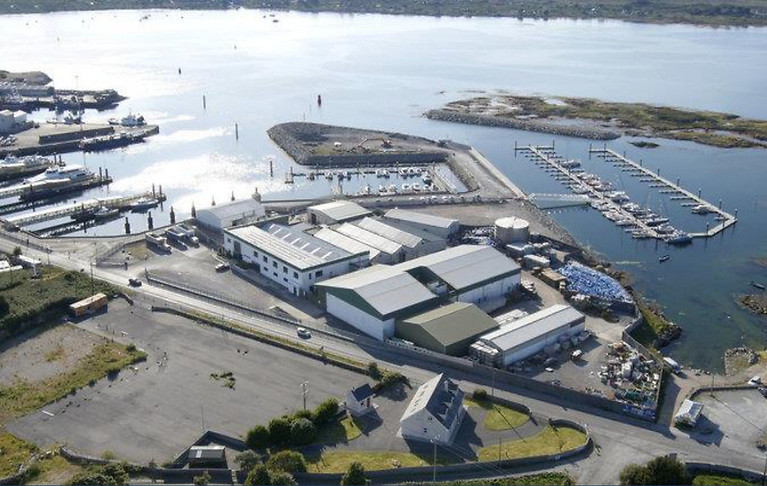
#IrishHarbours - Ros a Mhil in Connemara, is to get a new deep water quay, now that Galway county council has approved for the project.

According to Galway Bay Fm, the Department of the Marine has secured planning permission for the quay which will provide 200 metres of outside berthing frontage at the harbour.

The development at the harbour in Ros a Mhil will also include the construction of a reclamation area which will provide a hard surfaced link to the existing onshore.

The project will also include low concrete sea walls and an access road.

The development is subject to 6 planning conditions, including a stipulation that the Martello Tower be closely monitored before and during construction.

This is to conserve the architectural heritage of the area.

Also archeological monitoring must be undertaken during the construction phase.

Published in Irish Harbours

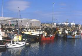
#Fishing - Funding for a new slipway has been allocated for the harbour at Ros a Mhil in Connemara.

According to Galway Bay FM, it’s part of a 27.9 million euro fund for 2018 Capital projects at Ireland’s six fishery harbour centres.

Minister for Agriculture, Food and the Marine, Michael Creed has announced the funding for Ros a Mhil, Howth, Castletownbere, Dingle, Dunmore East and Killybegs.

The funds which will provide for a new slipway in Ros a Mhil, a small craft harbour welfare building, deep water quay preparation, safety and maintenance and disability access.

Published in Fishing

Dublin Bay

Dublin Bay on the east coast of Ireland stretches over seven kilometres, from Howth Head on its northern tip to Dalkey Island in the south. It's a place most Dubliners simply take for granted, and one of the capital's least visited places. But there's more going on out there than you'd imagine.

The biggest boating centre is at Dun Laoghaire Harbour on the Bay's south shore that is home to over 1,500 pleasure craft, four waterfront yacht clubs and Ireland's largest marina.

The bay is rather shallow with many sandbanks and rocky outcrops, and was notorious in the past for shipwrecks, especially when the wind was from the east. Until modern times, many ships and their passengers were lost along the treacherous coastline from Howth to Dun Laoghaire, less than a kilometre from shore.

The Bay is a C-shaped inlet of the Irish Sea and is about 10 kilometres wide along its north-south base, and 7 km in length to its apex at the centre of the city of Dublin; stretching from Howth Head in the north to Dalkey Point in the south. North Bull Island is situated in the northwest part of the bay, where one of two major inshore sandbanks lie, and features a 5 km long sandy beach, Dollymount Strand, fronting an internationally recognised wildfowl reserve. Many of the rivers of Dublin reach the Irish Sea at Dublin Bay: the River Liffey, with the River Dodder flow received less than 1 km inland, River Tolka, and various smaller rivers and streams.

Dublin Bay FAQs

There are approximately ten beaches and bathing spots around Dublin Bay: Dollymount Strand; Forty Foot Bathing Place; Half Moon bathing spot; Merrion Strand; Bull Wall; Sandycove Beach; Sandymount Strand; Seapoint; Shelley Banks; Sutton, Burrow Beach

There are slipways on the north side of Dublin Bay at Clontarf, Sutton and on the southside at Dun Laoghaire Harbour, and in Dalkey at Coliemore and Bulloch Harbours.

Dublin Bay is administered by a number of Government Departments, three local authorities and several statutory agencies. Dublin Port Company is in charge of navigation on the Bay.

Dublin Bay is approximately 70 sq kilometres or 7,000 hectares. The Bay is about 10 kilometres wide along its north-south base, and seven km in length east-west to its peak at the centre of the city of Dublin; stretching from Howth Head in the north to Dalkey Point in the south.

Dun Laoghaire Harbour on the southside of the Bay has an East and West Pier, each one kilometre long; this is one of the largest human-made harbours in the world. There also piers or walls at the entrance to the River Liffey at Dublin city known as the Great North and South Walls. Other harbours on the Bay include Bulloch Harbour and Coliemore Harbours both at Dalkey.

There are two marinas on Dublin Bay. Ireland's largest marina with over 800 berths is on the southern shore at Dun Laoghaire Harbour. The other is at Poolbeg Yacht and Boat Club on the River Liffey close to Dublin City.

Car and passenger Ferries operate from Dublin Port to the UK, Isle of Man and France. A passenger ferry operates from Dun Laoghaire Harbour to Howth as well as providing tourist voyages around the bay.

Dublin Bay has two Islands. Bull Island at Clontarf and Dalkey Island on the southern shore of the Bay.

The River Liffey flows through Dublin city and into the Bay. Its tributaries include the River Dodder, the River Poddle and the River Camac.

Dollymount, Burrow and Seapoint beaches

Approximately 1,500 boats from small dinghies to motorboats to ocean-going yachts. The vast majority, over 1,000, are moored at Dun Laoghaire Harbour which is Ireland's boating capital.

In 1981, UNESCO recognised the importance of Dublin Bay by designating North Bull Island as a Biosphere because of its rare and internationally important habitats and species of wildlife. To support sustainable development, UNESCO’s concept of a Biosphere has evolved to include not just areas of ecological value but also the areas around them and the communities that live and work within these areas. There have since been additional international and national designations, covering much of Dublin Bay, to ensure the protection of its water quality and biodiversity. To fulfil these broader management aims for the ecosystem, the Biosphere was expanded in 2015. The Biosphere now covers Dublin Bay, reflecting its significant environmental, economic, cultural and tourism importance, and extends to over 300km² to include the bay, the shore and nearby residential areas.

On the Southside at Dun Laoghaire, there is the National Yacht Club, Royal St. George Yacht Club, Royal Irish Yacht Club and Dun Laoghaire Motor Yacht Club as well as Dublin Bay Sailing Club. In the city centre, there is Poolbeg Yacht and Boat Club. On the Northside of Dublin, there is Clontarf Yacht and Boat Club and Sutton Dinghy Club. While not on Dublin Bay, Howth Yacht Club is the major north Dublin Sailing centre.

© Afloat 2020