Menu

Ireland's sailing, boating & maritime magazine

Dublin Bay Boating News and Information

Displaying items by tag: Rowing boat
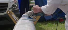
With the dress rehearsal last weekend at the European rowing championships in Brandenburg, Germany now over, athletes, including Irish rowers, proved their potential for the Olympic Games in Rio de Janeiro this summer using some of the latest rowing boats and equipment.

Did you ever wonder what it takes to make the perfect rowing shell? This rowing technology is explained by Glen Burston (Operation Manager Hudson) and Mark Emke (Head Coach Men Netherlands) in the video below. 

Published in Rowing
Tagged under

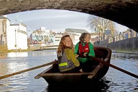
A unique new tidal guide assisting river users to circumnavigate the city’s waterways was launched yesterday at the River Lee Hotel. CORKUMNAVIGATION is a pocket-sized map published by Cork’s community boatyard, Meitheal Mara. The guide is aimed at helping locals and visitors alike discover the city from a new angle by kayak, canoe or rowing boat. See link below to purchase the guide.

According to Cathy Buchanan of Meitheal Mara, ''very few people know that you can actually row or paddle all around the city, and experience a very different and special side of Cork. As several of the bridges are particularly low and some weirs quite high, they can only be passed at certain tides. With the CORKUMNAVIGATION guide you can successfully navi­gate the city’s 29 bridges and eight weirs at vari­ous stages of the tide.''

Niamh Twomey, Cork City Council Heritage Officer, added ''The River Lee is one of the great unexploited spaces in Cork, offering a beautiful route around the historic city centre. This guide will give the growing number of river users the opportunity to experience the natural and built heritage of Cork from the River Lee. The guide also includes quirky historical facts contributed by the late Cían Ó Sé.''

corkumnavigate your way around the city 4

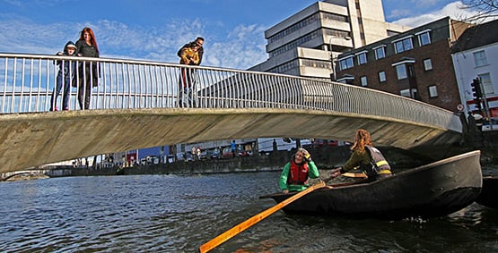
Corkumnavigate Cork city's 29 bridges and eight weirs with this latest pocket guide.

Originating near Gougane Barra in the Shehy Mountains, the River Lee flows east towards Cork City where it splits into two channels, form­ing the city's central island. Medieval Cork was a network of small river channels, which over the centuries have been covered in to leave just the north and south channels open. The river derives its name from the Irish "Laoi", meaning torrent or flood.

CORKUMNAVIGATION is a Meitheal Mara project, sponsored by Cork City Council and the River Lee Hotel. Fieldwork for the project was conducted in 2010 by the Cork Centre for Architectural Education, UCC and CIT, and sponsored by the Heritage Council.

The CORKUMNAVIGATION guide is available from Meitheal Mara via Afloat's Marine Market. Click HERE

Published in Book Review

#coastguard – A search is ongoing for a man missing in Lough Erne last night after a boat with six people onboard overturned.

Belfast Maritime Rescue Coordination Centre received a 999 call at 6.15pm from a member of the public, close to Portora Boat Club, Enniskillen. The caller reported that a rowing boat had capsized off the boat club.

Two of the vessels for hire in the Lough had rescued five people but one is still missing. He is not believed to have been wearing a lifejacket.

Enniskillen Coastguard Team were sent to the scene to search the shoreline whilst RNLI lifeboats based in Enniskillen and Carrybridge were sent to search the water. The Irish Coast Guard helicopter based at Sligo has also joined the search along with a PSNI boat.

The five people recovered from the water where treated by the Northern Ireland Ambulance Service.

Gary Young Watch Manager said:
"An extensive search is continuing at this time and weather conditions are favourable in the area."

Published in Coastguard

Dublin Bay

Dublin Bay on the east coast of Ireland stretches over seven kilometres, from Howth Head on its northern tip to Dalkey Island in the south. It's a place most Dubliners simply take for granted, and one of the capital's least visited places. But there's more going on out there than you'd imagine.

The biggest boating centre is at Dun Laoghaire Harbour on the Bay's south shore that is home to over 1,500 pleasure craft, four waterfront yacht clubs and Ireland's largest marina.

The bay is rather shallow with many sandbanks and rocky outcrops, and was notorious in the past for shipwrecks, especially when the wind was from the east. Until modern times, many ships and their passengers were lost along the treacherous coastline from Howth to Dun Laoghaire, less than a kilometre from shore.

The Bay is a C-shaped inlet of the Irish Sea and is about 10 kilometres wide along its north-south base, and 7 km in length to its apex at the centre of the city of Dublin; stretching from Howth Head in the north to Dalkey Point in the south. North Bull Island is situated in the northwest part of the bay, where one of two major inshore sandbanks lie, and features a 5 km long sandy beach, Dollymount Strand, fronting an internationally recognised wildfowl reserve. Many of the rivers of Dublin reach the Irish Sea at Dublin Bay: the River Liffey, with the River Dodder flow received less than 1 km inland, River Tolka, and various smaller rivers and streams.

Dublin Bay FAQs

There are approximately ten beaches and bathing spots around Dublin Bay: Dollymount Strand; Forty Foot Bathing Place; Half Moon bathing spot; Merrion Strand; Bull Wall; Sandycove Beach; Sandymount Strand; Seapoint; Shelley Banks; Sutton, Burrow Beach

There are slipways on the north side of Dublin Bay at Clontarf, Sutton and on the southside at Dun Laoghaire Harbour, and in Dalkey at Coliemore and Bulloch Harbours.

Dublin Bay is administered by a number of Government Departments, three local authorities and several statutory agencies. Dublin Port Company is in charge of navigation on the Bay.

Dublin Bay is approximately 70 sq kilometres or 7,000 hectares. The Bay is about 10 kilometres wide along its north-south base, and seven km in length east-west to its peak at the centre of the city of Dublin; stretching from Howth Head in the north to Dalkey Point in the south.

Dun Laoghaire Harbour on the southside of the Bay has an East and West Pier, each one kilometre long; this is one of the largest human-made harbours in the world. There also piers or walls at the entrance to the River Liffey at Dublin city known as the Great North and South Walls. Other harbours on the Bay include Bulloch Harbour and Coliemore Harbours both at Dalkey.

There are two marinas on Dublin Bay. Ireland's largest marina with over 800 berths is on the southern shore at Dun Laoghaire Harbour. The other is at Poolbeg Yacht and Boat Club on the River Liffey close to Dublin City.

Car and passenger Ferries operate from Dublin Port to the UK, Isle of Man and France. A passenger ferry operates from Dun Laoghaire Harbour to Howth as well as providing tourist voyages around the bay.

Dublin Bay has two Islands. Bull Island at Clontarf and Dalkey Island on the southern shore of the Bay.

The River Liffey flows through Dublin city and into the Bay. Its tributaries include the River Dodder, the River Poddle and the River Camac.

Dollymount, Burrow and Seapoint beaches

Approximately 1,500 boats from small dinghies to motorboats to ocean-going yachts. The vast majority, over 1,000, are moored at Dun Laoghaire Harbour which is Ireland's boating capital.

In 1981, UNESCO recognised the importance of Dublin Bay by designating North Bull Island as a Biosphere because of its rare and internationally important habitats and species of wildlife. To support sustainable development, UNESCO’s concept of a Biosphere has evolved to include not just areas of ecological value but also the areas around them and the communities that live and work within these areas. There have since been additional international and national designations, covering much of Dublin Bay, to ensure the protection of its water quality and biodiversity. To fulfil these broader management aims for the ecosystem, the Biosphere was expanded in 2015. The Biosphere now covers Dublin Bay, reflecting its significant environmental, economic, cultural and tourism importance, and extends to over 300km² to include the bay, the shore and nearby residential areas.

On the Southside at Dun Laoghaire, there is the National Yacht Club, Royal St. George Yacht Club, Royal Irish Yacht Club and Dun Laoghaire Motor Yacht Club as well as Dublin Bay Sailing Club. In the city centre, there is Poolbeg Yacht and Boat Club. On the Northside of Dublin, there is Clontarf Yacht and Boat Club and Sutton Dinghy Club. While not on Dublin Bay, Howth Yacht Club is the major north Dublin Sailing centre.

© Afloat 2020