Menu

Ireland's sailing, boating & maritime magazine

Dublin Bay Boating News and Information

Displaying items by tag: SILBO

#MarineScience - A deep-ocean drone was recovered with the help of the Marine Institute off the coast of Baltimore in West Cork earlier this month.

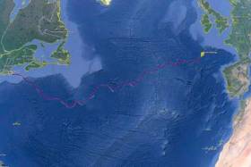
The SILBO autonomous glider, deployed by Teledyne Webb Research USA from Falmouth, Massachusetts in April last year, was sent on a mission to cross the North Atlantic and gather data from the ocean.

SILBO is one of 16 gliders undertaking 128,000km of co-ordinated surveys following an ocean gyre around the five global ocean basins. as part of the Unesco-endorsed Challenger mission.

Gliders look like torpedoes but lack propellors and an engine, instead relying on a movable internal ballast and external moveable fins to move across the ocean. They contain large battery packs to power the movement of the fins and change the internal ballast, as well as to power the glider’s sensors for ocean monitoring.

"Gliders like SILBO are equipped with a variety of sensors that enable scientists to monitor the ocean temperature, salinity, currents and other ocean conditions as well as offering a picture of places in the ocean that traditional satellites and research vessels may not be able to,” explained Aodhan Fitzgerald, RV operations manager at the Marine Institute, which used its remote operated vehicle to help recover the drone off Baltimore on Thursday 9 March.

“By contributing real-time data to a global portal, deep-sea gliders enable marine scientists to mutually benefit by creating a better assessment and understanding of the ocean and evaluating the ocean environment.”

Gliders like SILBO have the ability to go where it is impractical to send people. They can travel major distances over long periods of time, moving both horizontally and vertically through the ocean, continually gathering data.

The drones are also programmed to surface at designated times throughout their mission, allowing them to transmit the data they have collected to shore while at the same time downloading new mission instructions.

This two-way communications ability allows gliders to continually gather information about the most important and diverse regions of our ocean basins.

The Marine Institute says it is currently developing its capacity to use such gliders as they are an important tool for marine scientists to study and map the dynamic features of the ocean.

"With the opportunity to learn more about deep-sea glider capabilities, SILBO will be used for a training session led by Teledyne Webb Research at the Marine Institute's facilities in Galway,” Fitzgerald added.

“This will involve Irish and international glider technicians learning how to overhaul the glider and prepare it for its next mission before it is re-deployed from Irish shores to complete further mission transects for this global initiative.”

Published in Marine Science

Dublin Bay

Dublin Bay on the east coast of Ireland stretches over seven kilometres, from Howth Head on its northern tip to Dalkey Island in the south. It's a place most Dubliners simply take for granted, and one of the capital's least visited places. But there's more going on out there than you'd imagine.

The biggest boating centre is at Dun Laoghaire Harbour on the Bay's south shore that is home to over 1,500 pleasure craft, four waterfront yacht clubs and Ireland's largest marina.

The bay is rather shallow with many sandbanks and rocky outcrops, and was notorious in the past for shipwrecks, especially when the wind was from the east. Until modern times, many ships and their passengers were lost along the treacherous coastline from Howth to Dun Laoghaire, less than a kilometre from shore.

The Bay is a C-shaped inlet of the Irish Sea and is about 10 kilometres wide along its north-south base, and 7 km in length to its apex at the centre of the city of Dublin; stretching from Howth Head in the north to Dalkey Point in the south. North Bull Island is situated in the northwest part of the bay, where one of two major inshore sandbanks lie, and features a 5 km long sandy beach, Dollymount Strand, fronting an internationally recognised wildfowl reserve. Many of the rivers of Dublin reach the Irish Sea at Dublin Bay: the River Liffey, with the River Dodder flow received less than 1 km inland, River Tolka, and various smaller rivers and streams.

Dublin Bay FAQs

There are approximately ten beaches and bathing spots around Dublin Bay: Dollymount Strand; Forty Foot Bathing Place; Half Moon bathing spot; Merrion Strand; Bull Wall; Sandycove Beach; Sandymount Strand; Seapoint; Shelley Banks; Sutton, Burrow Beach

There are slipways on the north side of Dublin Bay at Clontarf, Sutton and on the southside at Dun Laoghaire Harbour, and in Dalkey at Coliemore and Bulloch Harbours.

Dublin Bay is administered by a number of Government Departments, three local authorities and several statutory agencies. Dublin Port Company is in charge of navigation on the Bay.

Dublin Bay is approximately 70 sq kilometres or 7,000 hectares. The Bay is about 10 kilometres wide along its north-south base, and seven km in length east-west to its peak at the centre of the city of Dublin; stretching from Howth Head in the north to Dalkey Point in the south.

Dun Laoghaire Harbour on the southside of the Bay has an East and West Pier, each one kilometre long; this is one of the largest human-made harbours in the world. There also piers or walls at the entrance to the River Liffey at Dublin city known as the Great North and South Walls. Other harbours on the Bay include Bulloch Harbour and Coliemore Harbours both at Dalkey.

There are two marinas on Dublin Bay. Ireland's largest marina with over 800 berths is on the southern shore at Dun Laoghaire Harbour. The other is at Poolbeg Yacht and Boat Club on the River Liffey close to Dublin City.

Car and passenger Ferries operate from Dublin Port to the UK, Isle of Man and France. A passenger ferry operates from Dun Laoghaire Harbour to Howth as well as providing tourist voyages around the bay.

Dublin Bay has two Islands. Bull Island at Clontarf and Dalkey Island on the southern shore of the Bay.

The River Liffey flows through Dublin city and into the Bay. Its tributaries include the River Dodder, the River Poddle and the River Camac.

Dollymount, Burrow and Seapoint beaches

Approximately 1,500 boats from small dinghies to motorboats to ocean-going yachts. The vast majority, over 1,000, are moored at Dun Laoghaire Harbour which is Ireland's boating capital.

In 1981, UNESCO recognised the importance of Dublin Bay by designating North Bull Island as a Biosphere because of its rare and internationally important habitats and species of wildlife. To support sustainable development, UNESCO’s concept of a Biosphere has evolved to include not just areas of ecological value but also the areas around them and the communities that live and work within these areas. There have since been additional international and national designations, covering much of Dublin Bay, to ensure the protection of its water quality and biodiversity. To fulfil these broader management aims for the ecosystem, the Biosphere was expanded in 2015. The Biosphere now covers Dublin Bay, reflecting its significant environmental, economic, cultural and tourism importance, and extends to over 300km² to include the bay, the shore and nearby residential areas.

On the Southside at Dun Laoghaire, there is the National Yacht Club, Royal St. George Yacht Club, Royal Irish Yacht Club and Dun Laoghaire Motor Yacht Club as well as Dublin Bay Sailing Club. In the city centre, there is Poolbeg Yacht and Boat Club. On the Northside of Dublin, there is Clontarf Yacht and Boat Club and Sutton Dinghy Club. While not on Dublin Bay, Howth Yacht Club is the major north Dublin Sailing centre.

© Afloat 2020