Displaying items by tag: Salmon Smolts
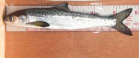
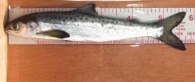
#Salmon - Wild Atlantic salmon smolts migrating to sea from Irish rivers can become infected with sea lice from West Coast salmon farms and suffer increased mortality soon after leaving the coast, cutting their numbers by half.
That’s the conclusion of a new study published in international journal Aquaculture Environment Interactions, which used 30 years of data from the River Erriff in the West of Ireland to evaluate the effect of sea lice from salmon aquaculture on wild Atlantic salmon.
The study, titled ‘Quantifying the contribution of sea lice from aquaculture to declining annual returns in a wild Atlantic salmon population’, examined sea lice production from salmon farming in Killary Harbour and its effect on the return of wild salmon to the Erriff, at the head of the harbour, in the following year.
Results from this long-term study indicate that returns of wild adult salmon can be reduced by more than 50% in years following high lice levels on nearby salmon farms during the smolt out-migration.
Inland Fisheries Ireland says sea lice from salmon farming have long been implicated in the collapse of sea trout stocks along the West Coast.
But this latest study, authored by Dr Samuel Shephard and Dr Paddy Gargan from IFI, is “the first to clearly demonstrate significant losses of wild Atlantic salmon due to infestation with sea lice from salmon farms,” it adds.
Dr Shephard says: “There has been a lot of discussion as to the importance of the sea lice impact in the context of environmental variation and changing ocean conditions.
“We find that the predicted 50% reduction in 1SW salmon returns following a high lice year is greater than the average year-to-year variation attributable to environmental effects.”
Modelled lice impact levels and a fitted stock-recruitment relationship were used to estimate how annual returns of Erriff salmon might have looked over the last 30 years, in the absence of a serious impact of sea lice from aquaculture.
Results suggest that Erriff salmon returns could now be twice as large as without observed anthropogenic lice impacts, but would probably show a similar long-term decline.
The River Erriff is designated as a Special Area of Conservation (SAC) for Atlantic salmon under the European Union Habitats Directive (92/43/EEC). Salmon smolts from the Erriff can be followed via a new online tool, as previously reported on Afloat.ie.
Dr Gargan explained that increased mortality of wild salmon due to the impact of sea lice can result in salmon stocks not reaching spawning targets or not being at favourable conservation status as required under the EU Habitats Directive.
It is therefore critical that sea lice levels are maintained at a very low level on farmed salmon in spring – and where this has not been achieved, that farmed fish are harvested before the wild salmon smolt migration period.
The authors conclude: “Many Atlantic salmon populations are already under pressure from (possibly climate-mediated) reductions in marine survival. The addition of significant lice-related mortality during the coastal stage of smolt out-migration could be critical.”
Follow Salmon Smolts In River Erriff Via New Online Tool
#SalmonSmolts - Inland Fisheries Ireland (IFI) has launched the SMOLTRACK project, which gives the public the opportunity to follow the numbers of juvenile salmon making their journey down the River Erriff.
The EU-funded NASCO project will see IFI work alongside partners in Northern Ireland (River Bush), England (River Tamar), Spain (River Ulla and River Tea) and Denmark (River Skjern) in rolling out a counting, tagging and tracking system.
Traps are used to catch migrating salmon smolts for tagging before releasing them to continue their migration journey. In order to provide stakeholders – angling enthusiasts included – with the opportunity to follow and compare the migration timing of smolts in several countries, the daily numbers of salmon smolts counted in each system is uploaded for online viewing.
In Ireland, tagging is being carried out on salmon smolts from the Black River, a tributary of the River Erriff, which itself is the National Salmonid Index Catchment (NSIC).
The Erriff in Co Mayo is one of the premier salmon fishing rivers in Ireland and its smolt run typically occurs over six weeks during April and May. This year, the smolt run commenced on the river on Monday 3 April, with 289 salmon smolts counted on the system as of today (Monday 24 April).
The salmon smolts are tagged with miniature acoustic transmitters and their subsequent migration is followed via acoustic listening stations situated at various locations.
This information will help scientists to understand the survival rates of salmon smolts during their migration through the lower parts of rivers, estuaries and coastal areas, in addition to providing data on smolt run timing and migration behaviour.
The project will provide new data which will inform future salmon management and conservation work.
“This is an exciting project which will allow us to gather new information around the survival and timing of salmon smolts journeying seaward through the River Erriff, and into and through inshore coastal waters,” says Dr Cathal Gallagher, IFI’s head of research and development.
“We look forward to determining more about the smolts once they have been tagged by following their migration journey. As we are working with partners in Northern Ireland, England, Spain and Denmark, we can also learn from the data gathered in their regions.
“Ultimately, this information will inform our work in the area of salmon conservation which will prove invaluable to Ireland’s fisheries resource in the long term.”


