Menu

Ireland's sailing, boating & maritime magazine

Dublin Bay Boating News and Information

Displaying items by tag: Shipping Forecast

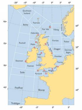
#ShippingForecast - Do you know your Dogger from your Fisher? If so, it’s likely you know the Shipping Forecast, the 150th anniversary of which was marked last Thursday 24 August.

But do you know how the specialised weather broadcast came to be? How many areas it comprises? Or what day it failed to air for the first time in almost a century?

All that and more are included in Yachting & Boating World’s list of 10 interesting facts about the four-times-daily institution for mariners of all stripes in British and Irish waters.

Published in Weather
Tagged under

#Weather - The BBC's Shipping Forecast failed to air as scheduled yesterday morning for the first time in 90 years.

The Guardian reports that the mishap was the result of a technical glitch whereby BBC Radio 4's overnight switchover to the World Service did not switch back as planned in time for the 5.20am weather bulletin for the UK and Ireland's shipping areas.

Many listeners were quick to voice their displease on social media, though the forecast did eventually go out at 6.40am, an hour and 20 minutes late.

However, the glitch may be seen as a bad omen for some after warnings late last year over a transmitter shutdown now ongoing that may affect reception of the Shipping Forecast in the Irish Sea.

Published in Weather
Tagged under

#Cruising - Yachting Monthly reports on an online questionnaire launched by the BBC to gauge the audience of the Shipping Forecast for the waters around Britain and Ireland.

The daily broadcast is a Radio 4 institution, but its future is far from certain in light of the increased use of the internet by sailors to download weather predictions.

According to meteorologist Frank Singleton, it's only a matter of time before the Shipping Forecast comes to an end. (As it is, there may be interruptions to the service next year.)

Stuart Carruthers of the Royal Yachting Association (RYA) has described the online survey as a "cunning ruse" to provide an excuse for ending the service, which he says is "essential" to yachts that have no internet access at sea.

It's a charge that's been denied by the BBC, who noted that the RYA has itself recently sought the opinions of its members on usage of the Shipping Forecast.

Yachting Monthly has more on the story HERE.

Published in Cruising

#MarineWarning - Practical Boat Owner gives plenty of prior warning on plans by the BBC to shut down its Droitwich transmitter for maintenance next year, which could affect the Shipping Forecast for the Irish Sea.

The 12:01 shipping forecast "will potentially be transmitted at a lower power or ma be in audible on LW" for the period from April to August 2014 as Droitwich undergoes essential maintenance.

PBO has more on the story HERE.

Published in Marine Warning

Dublin Bay

Dublin Bay on the east coast of Ireland stretches over seven kilometres, from Howth Head on its northern tip to Dalkey Island in the south. It's a place most Dubliners simply take for granted, and one of the capital's least visited places. But there's more going on out there than you'd imagine.

The biggest boating centre is at Dun Laoghaire Harbour on the Bay's south shore that is home to over 1,500 pleasure craft, four waterfront yacht clubs and Ireland's largest marina.

The bay is rather shallow with many sandbanks and rocky outcrops, and was notorious in the past for shipwrecks, especially when the wind was from the east. Until modern times, many ships and their passengers were lost along the treacherous coastline from Howth to Dun Laoghaire, less than a kilometre from shore.

The Bay is a C-shaped inlet of the Irish Sea and is about 10 kilometres wide along its north-south base, and 7 km in length to its apex at the centre of the city of Dublin; stretching from Howth Head in the north to Dalkey Point in the south. North Bull Island is situated in the northwest part of the bay, where one of two major inshore sandbanks lie, and features a 5 km long sandy beach, Dollymount Strand, fronting an internationally recognised wildfowl reserve. Many of the rivers of Dublin reach the Irish Sea at Dublin Bay: the River Liffey, with the River Dodder flow received less than 1 km inland, River Tolka, and various smaller rivers and streams.

Dublin Bay FAQs

There are approximately ten beaches and bathing spots around Dublin Bay: Dollymount Strand; Forty Foot Bathing Place; Half Moon bathing spot; Merrion Strand; Bull Wall; Sandycove Beach; Sandymount Strand; Seapoint; Shelley Banks; Sutton, Burrow Beach

There are slipways on the north side of Dublin Bay at Clontarf, Sutton and on the southside at Dun Laoghaire Harbour, and in Dalkey at Coliemore and Bulloch Harbours.

Dublin Bay is administered by a number of Government Departments, three local authorities and several statutory agencies. Dublin Port Company is in charge of navigation on the Bay.

Dublin Bay is approximately 70 sq kilometres or 7,000 hectares. The Bay is about 10 kilometres wide along its north-south base, and seven km in length east-west to its peak at the centre of the city of Dublin; stretching from Howth Head in the north to Dalkey Point in the south.

Dun Laoghaire Harbour on the southside of the Bay has an East and West Pier, each one kilometre long; this is one of the largest human-made harbours in the world. There also piers or walls at the entrance to the River Liffey at Dublin city known as the Great North and South Walls. Other harbours on the Bay include Bulloch Harbour and Coliemore Harbours both at Dalkey.

There are two marinas on Dublin Bay. Ireland's largest marina with over 800 berths is on the southern shore at Dun Laoghaire Harbour. The other is at Poolbeg Yacht and Boat Club on the River Liffey close to Dublin City.

Car and passenger Ferries operate from Dublin Port to the UK, Isle of Man and France. A passenger ferry operates from Dun Laoghaire Harbour to Howth as well as providing tourist voyages around the bay.

Dublin Bay has two Islands. Bull Island at Clontarf and Dalkey Island on the southern shore of the Bay.

The River Liffey flows through Dublin city and into the Bay. Its tributaries include the River Dodder, the River Poddle and the River Camac.

Dollymount, Burrow and Seapoint beaches

Approximately 1,500 boats from small dinghies to motorboats to ocean-going yachts. The vast majority, over 1,000, are moored at Dun Laoghaire Harbour which is Ireland's boating capital.

In 1981, UNESCO recognised the importance of Dublin Bay by designating North Bull Island as a Biosphere because of its rare and internationally important habitats and species of wildlife. To support sustainable development, UNESCO’s concept of a Biosphere has evolved to include not just areas of ecological value but also the areas around them and the communities that live and work within these areas. There have since been additional international and national designations, covering much of Dublin Bay, to ensure the protection of its water quality and biodiversity. To fulfil these broader management aims for the ecosystem, the Biosphere was expanded in 2015. The Biosphere now covers Dublin Bay, reflecting its significant environmental, economic, cultural and tourism importance, and extends to over 300km² to include the bay, the shore and nearby residential areas.

On the Southside at Dun Laoghaire, there is the National Yacht Club, Royal St. George Yacht Club, Royal Irish Yacht Club and Dun Laoghaire Motor Yacht Club as well as Dublin Bay Sailing Club. In the city centre, there is Poolbeg Yacht and Boat Club. On the Northside of Dublin, there is Clontarf Yacht and Boat Club and Sutton Dinghy Club. While not on Dublin Bay, Howth Yacht Club is the major north Dublin Sailing centre.

© Afloat 2020