Menu

Ireland's sailing, boating & maritime magazine

Dublin Bay Boating News and Information

Displaying items by tag: Simon Knowles

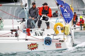
#RB&I - Conor Fogerty and Simon Knowles in the Sunfast 3600 BAM! were yesterday evening narrowly leading the two-handed division in the RORC Sevenstar Round Britain & Ireland’s 1,805-mile marathon, writes W M Nixon.

The Howth Yacht Club duo were trying to keep cover on the Figaro 2 El Velosolex SL Energies Group (Bejamin Schwartz & Chen Jin Hao) close to the north of them, and Sunfast 3600 sister-ship Game On (Ian Hoddle & Ollie Wyatt) to their southeast as the fleet approached the massive tidal gate of Portland Bill, sailing hard on the wind.

El Velsolex to the north found freshening breeze in under Portland Island, which also got her more quickly into the Bill’s beneficial tidal shadow.

With the local sharpening of the breeze, she was able to make a clinical of job of rounding Portland Bill within a stone’s throw of the shore in slacker water, and then lengthening away into Lyme Bay on port tack.

This left BAM! with the least bad option of following, and though she too was right in on the shore at the point itself, the spark had gone from the breeze and for a while she was hung up at only 2.2 knots over the ground.

El Velosolex, meanwhile, got away into a lead of thee miles before the Irish boat got going again, but at least Game On had been left well astern, so much so that she opted to go well offshore.

Any beat westward in the English Channel will find a varying pattern of wind strengths, and through the night as the fleet slowly neared Start Point with the Mach 40.3 Corum (Nicolas Troussel) leading narrowly on the water from Phil Sharp’s Class 40 Imerys Clean Energy, at times those inshore were favoured.

But then those offshore began to get better breezes, and when the group to the north closed with the southerly group off Start Point around 7am this morning, El Velosolex had lengthened further to eight miles ahead of BAM!, but the latter was now neck-and-neck with Game On.

The two Sunfast 3600s — less than two miles apart — elected to continue the offshore tack on starboard, but at 10.29am El Velosolex tacked onto port.

This was the state of affairs at the noon position, with the Figaro still heading for the distant shore, while Game On and BAM! are holding on starboard and having a right dong, Game On ahead by 1.7 sea miles and sailing at 6.3 knots, and Bam! on her weather quarter shown as sailing at 6.4 knots. And they still have 1,670 miles to go.

Crossing the Celtic Sea from the Isles of Scilly to southwest Ireland will be interesting, as the wind is forecast to be bang on the nose at first, but backing through tomorrow. This suggests that keeping to the left will be a strategic imperative, but for how long will be anyone’s guess.

Race Tracker here: http://yb.tl/rbni2018

Published in Rd Britain & Ireland

Dublin Bay

Dublin Bay on the east coast of Ireland stretches over seven kilometres, from Howth Head on its northern tip to Dalkey Island in the south. It's a place most Dubliners simply take for granted, and one of the capital's least visited places. But there's more going on out there than you'd imagine.

The biggest boating centre is at Dun Laoghaire Harbour on the Bay's south shore that is home to over 1,500 pleasure craft, four waterfront yacht clubs and Ireland's largest marina.

The bay is rather shallow with many sandbanks and rocky outcrops, and was notorious in the past for shipwrecks, especially when the wind was from the east. Until modern times, many ships and their passengers were lost along the treacherous coastline from Howth to Dun Laoghaire, less than a kilometre from shore.

The Bay is a C-shaped inlet of the Irish Sea and is about 10 kilometres wide along its north-south base, and 7 km in length to its apex at the centre of the city of Dublin; stretching from Howth Head in the north to Dalkey Point in the south. North Bull Island is situated in the northwest part of the bay, where one of two major inshore sandbanks lie, and features a 5 km long sandy beach, Dollymount Strand, fronting an internationally recognised wildfowl reserve. Many of the rivers of Dublin reach the Irish Sea at Dublin Bay: the River Liffey, with the River Dodder flow received less than 1 km inland, River Tolka, and various smaller rivers and streams.

Dublin Bay FAQs

There are approximately ten beaches and bathing spots around Dublin Bay: Dollymount Strand; Forty Foot Bathing Place; Half Moon bathing spot; Merrion Strand; Bull Wall; Sandycove Beach; Sandymount Strand; Seapoint; Shelley Banks; Sutton, Burrow Beach

There are slipways on the north side of Dublin Bay at Clontarf, Sutton and on the southside at Dun Laoghaire Harbour, and in Dalkey at Coliemore and Bulloch Harbours.

Dublin Bay is administered by a number of Government Departments, three local authorities and several statutory agencies. Dublin Port Company is in charge of navigation on the Bay.

Dublin Bay is approximately 70 sq kilometres or 7,000 hectares. The Bay is about 10 kilometres wide along its north-south base, and seven km in length east-west to its peak at the centre of the city of Dublin; stretching from Howth Head in the north to Dalkey Point in the south.

Dun Laoghaire Harbour on the southside of the Bay has an East and West Pier, each one kilometre long; this is one of the largest human-made harbours in the world. There also piers or walls at the entrance to the River Liffey at Dublin city known as the Great North and South Walls. Other harbours on the Bay include Bulloch Harbour and Coliemore Harbours both at Dalkey.

There are two marinas on Dublin Bay. Ireland's largest marina with over 800 berths is on the southern shore at Dun Laoghaire Harbour. The other is at Poolbeg Yacht and Boat Club on the River Liffey close to Dublin City.

Car and passenger Ferries operate from Dublin Port to the UK, Isle of Man and France. A passenger ferry operates from Dun Laoghaire Harbour to Howth as well as providing tourist voyages around the bay.

Dublin Bay has two Islands. Bull Island at Clontarf and Dalkey Island on the southern shore of the Bay.

The River Liffey flows through Dublin city and into the Bay. Its tributaries include the River Dodder, the River Poddle and the River Camac.

Dollymount, Burrow and Seapoint beaches

Approximately 1,500 boats from small dinghies to motorboats to ocean-going yachts. The vast majority, over 1,000, are moored at Dun Laoghaire Harbour which is Ireland's boating capital.

In 1981, UNESCO recognised the importance of Dublin Bay by designating North Bull Island as a Biosphere because of its rare and internationally important habitats and species of wildlife. To support sustainable development, UNESCO’s concept of a Biosphere has evolved to include not just areas of ecological value but also the areas around them and the communities that live and work within these areas. There have since been additional international and national designations, covering much of Dublin Bay, to ensure the protection of its water quality and biodiversity. To fulfil these broader management aims for the ecosystem, the Biosphere was expanded in 2015. The Biosphere now covers Dublin Bay, reflecting its significant environmental, economic, cultural and tourism importance, and extends to over 300km² to include the bay, the shore and nearby residential areas.

On the Southside at Dun Laoghaire, there is the National Yacht Club, Royal St. George Yacht Club, Royal Irish Yacht Club and Dun Laoghaire Motor Yacht Club as well as Dublin Bay Sailing Club. In the city centre, there is Poolbeg Yacht and Boat Club. On the Northside of Dublin, there is Clontarf Yacht and Boat Club and Sutton Dinghy Club. While not on Dublin Bay, Howth Yacht Club is the major north Dublin Sailing centre.

© Afloat 2020