Menu

Ireland's sailing, boating & maritime magazine

Dublin Bay Boating News and Information

Displaying items by tag: Storm Aiden

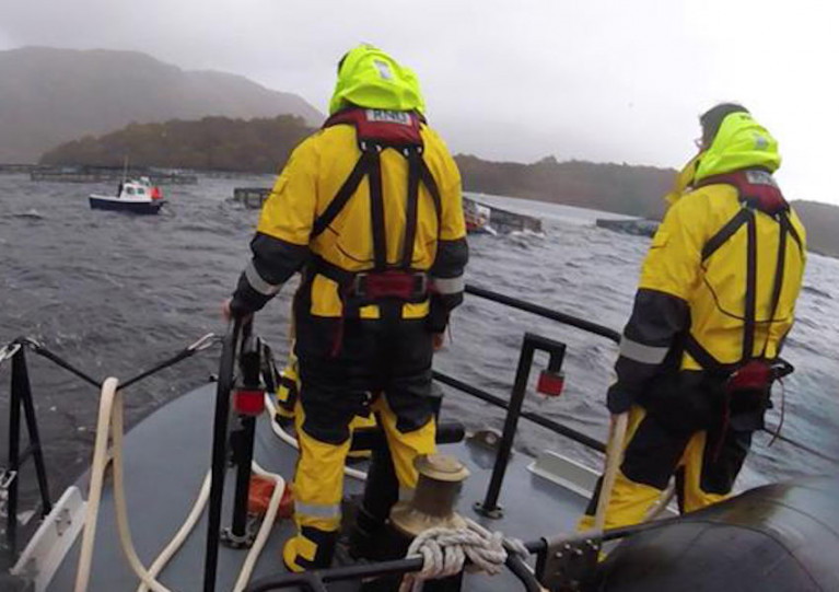
As Storm Aiden brought its gale-force winds and driving rain from Ireland to western Scotland, Oban RNLI launched to assist a fishing vessel in distress in Loch Etive.

The 22ft fishing boat, with four on board, had broken down west of Airds Point and managed to secure to a fish farm mooring while they awaited assistance yesterday afternoon, Saturday 31 October.

Meanwhile, the lifeboat launched amid heavy seas and 60mph gusts and reached the scene within half an hour to set up a tow to Taynulit pier, from where the fishermen had set out earlier in the day.

On arrival, however, the pier was submerged by the extremely high tide, and with no other shelter in the area it was decided to secure the fishing vessel to a mooring in Airds Bay and bring its crew ashore at Dunstaffnage with the lifeboat.

Oban RNLI coxswain Ally Cerexhe said: “Although the lochs may appear to provide some shelter, the strong winds and high tides still pose the same risk.”

Published in RNLI Lifeboats

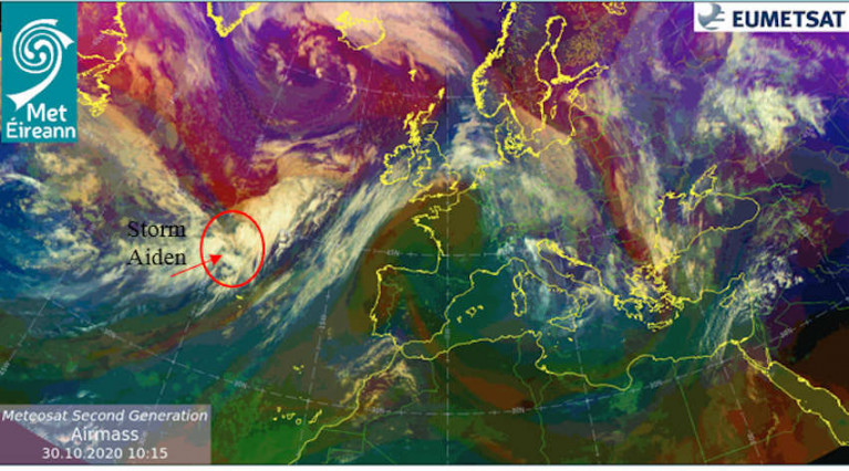
A Status Orange weather warning is in place for all Irish coastal waters and the Irish Sea as strong gales are set to develop overnight with the arrival of Storm Aiden, the first of the new storm season.

Met Éireann reports that winds will reach storm force off the South and South West Coasts in the early hours of tomorrow, Saturday 31 October, later veering westerly during the day and reaching gale to storm force on all coastal waters and the Irish Sea.

Tomorrow morning’s winds will reach mean speeds of 65 to 80km/h, with severe and damaging gusts of 100 to 130km/h, affecting Cork, Kerry, Waterford and Wexford as well as Carlow, Kilkenny and Wicklow.

Later in the day these severe winds will veer west over counties Clare, Galway, Mayo, Sligo and Donegal. The rest of Ireland is under Status Yellow with lesser but still potentially damaging gusts forecast, as well as a risk of coastal flooding.

A surfer rides a large wave at Mullaghmore, Co Sligo on Wednesday (Noel Fitzpatrick/Met Éireann)A surfer rides a large wave at Mullaghmore, Co Sligo on Wednesday | Noel Fitzpatrick/Met Éireann

The storm follows the remnants of Hurricane Epsilon, which brought ‘phenomenal’ class seas to the West Coast on Tuesday and Wednesday — just the ticket for the big wave surfing enthusiasts of Mullaghmore Head.

Local surfers told RTÉ News that the swells of earlier this week were some of the biggest they’ve ever seen here, and Conor Maguire was among those up for the challenge.

Published in Weather
Tagged under

Dublin Bay

Dublin Bay on the east coast of Ireland stretches over seven kilometres, from Howth Head on its northern tip to Dalkey Island in the south. It's a place most Dubliners simply take for granted, and one of the capital's least visited places. But there's more going on out there than you'd imagine.

The biggest boating centre is at Dun Laoghaire Harbour on the Bay's south shore that is home to over 1,500 pleasure craft, four waterfront yacht clubs and Ireland's largest marina.

The bay is rather shallow with many sandbanks and rocky outcrops, and was notorious in the past for shipwrecks, especially when the wind was from the east. Until modern times, many ships and their passengers were lost along the treacherous coastline from Howth to Dun Laoghaire, less than a kilometre from shore.

The Bay is a C-shaped inlet of the Irish Sea and is about 10 kilometres wide along its north-south base, and 7 km in length to its apex at the centre of the city of Dublin; stretching from Howth Head in the north to Dalkey Point in the south. North Bull Island is situated in the northwest part of the bay, where one of two major inshore sandbanks lie, and features a 5 km long sandy beach, Dollymount Strand, fronting an internationally recognised wildfowl reserve. Many of the rivers of Dublin reach the Irish Sea at Dublin Bay: the River Liffey, with the River Dodder flow received less than 1 km inland, River Tolka, and various smaller rivers and streams.

Dublin Bay FAQs

There are approximately ten beaches and bathing spots around Dublin Bay: Dollymount Strand; Forty Foot Bathing Place; Half Moon bathing spot; Merrion Strand; Bull Wall; Sandycove Beach; Sandymount Strand; Seapoint; Shelley Banks; Sutton, Burrow Beach

There are slipways on the north side of Dublin Bay at Clontarf, Sutton and on the southside at Dun Laoghaire Harbour, and in Dalkey at Coliemore and Bulloch Harbours.

Dublin Bay is administered by a number of Government Departments, three local authorities and several statutory agencies. Dublin Port Company is in charge of navigation on the Bay.

Dublin Bay is approximately 70 sq kilometres or 7,000 hectares. The Bay is about 10 kilometres wide along its north-south base, and seven km in length east-west to its peak at the centre of the city of Dublin; stretching from Howth Head in the north to Dalkey Point in the south.

Dun Laoghaire Harbour on the southside of the Bay has an East and West Pier, each one kilometre long; this is one of the largest human-made harbours in the world. There also piers or walls at the entrance to the River Liffey at Dublin city known as the Great North and South Walls. Other harbours on the Bay include Bulloch Harbour and Coliemore Harbours both at Dalkey.

There are two marinas on Dublin Bay. Ireland's largest marina with over 800 berths is on the southern shore at Dun Laoghaire Harbour. The other is at Poolbeg Yacht and Boat Club on the River Liffey close to Dublin City.

Car and passenger Ferries operate from Dublin Port to the UK, Isle of Man and France. A passenger ferry operates from Dun Laoghaire Harbour to Howth as well as providing tourist voyages around the bay.

Dublin Bay has two Islands. Bull Island at Clontarf and Dalkey Island on the southern shore of the Bay.

The River Liffey flows through Dublin city and into the Bay. Its tributaries include the River Dodder, the River Poddle and the River Camac.

Dollymount, Burrow and Seapoint beaches

Approximately 1,500 boats from small dinghies to motorboats to ocean-going yachts. The vast majority, over 1,000, are moored at Dun Laoghaire Harbour which is Ireland's boating capital.

In 1981, UNESCO recognised the importance of Dublin Bay by designating North Bull Island as a Biosphere because of its rare and internationally important habitats and species of wildlife. To support sustainable development, UNESCO’s concept of a Biosphere has evolved to include not just areas of ecological value but also the areas around them and the communities that live and work within these areas. There have since been additional international and national designations, covering much of Dublin Bay, to ensure the protection of its water quality and biodiversity. To fulfil these broader management aims for the ecosystem, the Biosphere was expanded in 2015. The Biosphere now covers Dublin Bay, reflecting its significant environmental, economic, cultural and tourism importance, and extends to over 300km² to include the bay, the shore and nearby residential areas.

On the Southside at Dun Laoghaire, there is the National Yacht Club, Royal St. George Yacht Club, Royal Irish Yacht Club and Dun Laoghaire Motor Yacht Club as well as Dublin Bay Sailing Club. In the city centre, there is Poolbeg Yacht and Boat Club. On the Northside of Dublin, there is Clontarf Yacht and Boat Club and Sutton Dinghy Club. While not on Dublin Bay, Howth Yacht Club is the major north Dublin Sailing centre.

© Afloat 2020