Menu

Ireland's sailing, boating & maritime magazine

Dublin Bay Boating News and Information

Displaying items by tag: Storm Diana

Irish Coast Guard teams across Ireland have responded to incidents related to the extreme conditions brought by Storm Diana over the last two days.

Dun Laoghaire Coast Guard was tasked at lunchtime on Tuesday (27 November) to extract a member of the public that had walked out the South Bull wall during stormy conditions.

The safest option in that situation was the casualty to take shelter until the tide dropped.

Yesterday afternoon (Wednesday 28 November), the team was called out to the Shankill shoreline close to Shanganagh Water Treatment plant to reports of a vehicle submerged in water with person a trapped.

Dun Laoghaire Coast Guard were tasked immediately along with Rescue 116 from Dublin Airport and Dun Laoghaire RNLI. While crews were responding to the incident, the casualty was rescued by his colleagues. All crews were stood down.

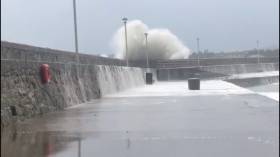
Shortly after, Dun Laoghaire Coast Guard was tasked to another incident at the town’s East Pier, where members of the public were stranded due to waves breaching the pier wall.

On arrival, Dun Laoghaire Coast Guard members identified a few members of public on the pier and advised them to relocate to a safer location.

Elsewhere, Crosshaven Coast Guard was tasked several times, starting on Tuesday evening with a person who had fallen overboard from a yacht and had been in the water for almost an hour.

The casualty was evacuated to Crosshaven RNLI’s lifeboat station, while the coastguard crew refloated their vessel that had gone aground.

Crosshaven was tasked again yesterday morning to recover a yacht after it broke its mooring near Drakes Pool. A tow was quickly established and casualty vessel brought to safety to a Royal Cork Yacht Club mooring.

The Irish Coast Guard strongly advises the public to stay away from exposed beaches, cliffs and piers, harbour walls and promenades along the coast during storm conditions.

Remember to Stay Back, Stay High and Stay Dry.

If you see someone in difficulty in the sea, or on the shore dial 999/112 and ask for the coastguard.

Published in Coastguard

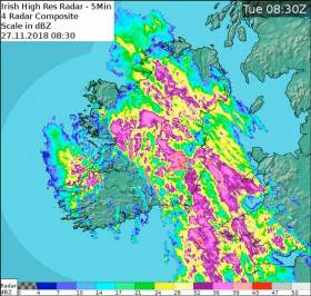
Met Éireann says a Status Yellow gale warning is in effect on all Irish coastal waters and on the Irish Sea as of 6am this morning (Tuesday 27 November) as the first of two waves of stormy weather conditions passes over the country.

Heavy downpours with spot flooding, and gales and severe gusts will be experienced nationwide, particularly from Dublin and much of south Leinster, across Munster, up to west Connacht and Donegal.

Winds are expected die down after 3pm but will pick up again this evening and overnight into Wednesday 28 November, again with very blustery strong to gale force winds, southeast veering southwest. Donegal Weather Channel predicts a potential Status Orange warning later today.

Published in Weather
Tagged under

Dublin Bay

Dublin Bay on the east coast of Ireland stretches over seven kilometres, from Howth Head on its northern tip to Dalkey Island in the south. It's a place most Dubliners simply take for granted, and one of the capital's least visited places. But there's more going on out there than you'd imagine.

The biggest boating centre is at Dun Laoghaire Harbour on the Bay's south shore that is home to over 1,500 pleasure craft, four waterfront yacht clubs and Ireland's largest marina.

The bay is rather shallow with many sandbanks and rocky outcrops, and was notorious in the past for shipwrecks, especially when the wind was from the east. Until modern times, many ships and their passengers were lost along the treacherous coastline from Howth to Dun Laoghaire, less than a kilometre from shore.

The Bay is a C-shaped inlet of the Irish Sea and is about 10 kilometres wide along its north-south base, and 7 km in length to its apex at the centre of the city of Dublin; stretching from Howth Head in the north to Dalkey Point in the south. North Bull Island is situated in the northwest part of the bay, where one of two major inshore sandbanks lie, and features a 5 km long sandy beach, Dollymount Strand, fronting an internationally recognised wildfowl reserve. Many of the rivers of Dublin reach the Irish Sea at Dublin Bay: the River Liffey, with the River Dodder flow received less than 1 km inland, River Tolka, and various smaller rivers and streams.

Dublin Bay FAQs

There are approximately ten beaches and bathing spots around Dublin Bay: Dollymount Strand; Forty Foot Bathing Place; Half Moon bathing spot; Merrion Strand; Bull Wall; Sandycove Beach; Sandymount Strand; Seapoint; Shelley Banks; Sutton, Burrow Beach

There are slipways on the north side of Dublin Bay at Clontarf, Sutton and on the southside at Dun Laoghaire Harbour, and in Dalkey at Coliemore and Bulloch Harbours.

Dublin Bay is administered by a number of Government Departments, three local authorities and several statutory agencies. Dublin Port Company is in charge of navigation on the Bay.

Dublin Bay is approximately 70 sq kilometres or 7,000 hectares. The Bay is about 10 kilometres wide along its north-south base, and seven km in length east-west to its peak at the centre of the city of Dublin; stretching from Howth Head in the north to Dalkey Point in the south.

Dun Laoghaire Harbour on the southside of the Bay has an East and West Pier, each one kilometre long; this is one of the largest human-made harbours in the world. There also piers or walls at the entrance to the River Liffey at Dublin city known as the Great North and South Walls. Other harbours on the Bay include Bulloch Harbour and Coliemore Harbours both at Dalkey.

There are two marinas on Dublin Bay. Ireland's largest marina with over 800 berths is on the southern shore at Dun Laoghaire Harbour. The other is at Poolbeg Yacht and Boat Club on the River Liffey close to Dublin City.

Car and passenger Ferries operate from Dublin Port to the UK, Isle of Man and France. A passenger ferry operates from Dun Laoghaire Harbour to Howth as well as providing tourist voyages around the bay.

Dublin Bay has two Islands. Bull Island at Clontarf and Dalkey Island on the southern shore of the Bay.

The River Liffey flows through Dublin city and into the Bay. Its tributaries include the River Dodder, the River Poddle and the River Camac.

Dollymount, Burrow and Seapoint beaches

Approximately 1,500 boats from small dinghies to motorboats to ocean-going yachts. The vast majority, over 1,000, are moored at Dun Laoghaire Harbour which is Ireland's boating capital.

In 1981, UNESCO recognised the importance of Dublin Bay by designating North Bull Island as a Biosphere because of its rare and internationally important habitats and species of wildlife. To support sustainable development, UNESCO’s concept of a Biosphere has evolved to include not just areas of ecological value but also the areas around them and the communities that live and work within these areas. There have since been additional international and national designations, covering much of Dublin Bay, to ensure the protection of its water quality and biodiversity. To fulfil these broader management aims for the ecosystem, the Biosphere was expanded in 2015. The Biosphere now covers Dublin Bay, reflecting its significant environmental, economic, cultural and tourism importance, and extends to over 300km² to include the bay, the shore and nearby residential areas.

On the Southside at Dun Laoghaire, there is the National Yacht Club, Royal St. George Yacht Club, Royal Irish Yacht Club and Dun Laoghaire Motor Yacht Club as well as Dublin Bay Sailing Club. In the city centre, there is Poolbeg Yacht and Boat Club. On the Northside of Dublin, there is Clontarf Yacht and Boat Club and Sutton Dinghy Club. While not on Dublin Bay, Howth Yacht Club is the major north Dublin Sailing centre.

© Afloat 2020