Menu

Ireland's sailing, boating & maritime magazine

Dublin Bay Boating News and Information

Displaying items by tag: Tom O'Mahony

#irishsailing – There are just 17,000 registered leisure sailors in Ireland at present. There has been a decline in sailing, the level of activity has weakened, clubs are losing membership and several marinas have space available for the first time.

The only official participation figure available is for those 17,000 members of clubs registered with the Irish Sailing Association. There are many more sailors who own boats and use them outside of the club structures, so the actual participation levels could be two or three times that number. But there is no doubt about the decline in activity in the sport. The effects of the economic recession, people having less disposable income, loss of jobs, emigration, have all had their effects.

Brian Craig, one of the Directors of the ISA discusses the challenges facing the sport in a frank and direct interview on the current edition of THIS ISLAND NATION, the niche maritime radio programme, which you can hear here. The interview ranges across the still-present perception of the sport as 'elitist' and the methods needed to change this and to increase involvement in the sport.

"There is still a strong core foundation to the sport," Brian Craig says in the interview which discusses the Strategic Plan the Association has drawn up and which has been considered at meetings of ISA members around the country.

BRIAN_CRAIG.jpg

Brian Craig

The plan will be put before the ISA annual general meeting in Portlaoise on March 28 for adoption.

GOVERNMENT THINKS THERE IS AN IRISH LANDBRIDGE!

"We are a funny country. We are surrounded by water. We have a Government that thinks there is a landbridge somewhere, but they don't know where it is."

That was the comment of former seafarer Tom O'Mahony when he spoke to the programme at the annual Remembrance Ceremony for those lost at sea in the town of Youghal on the East Cork coastline. It is a coastal town with a great schooner tradition and memories of seafarers who ranged from the River Blackwater onto the world's oceans in various types of vessels. It is also where the programme is compiled, edited, recorded and transmitted every Monday fortnight at 6.30 p.m. and later each fortnight on Near FM in Dublin, Dundalk FM, Dublin South FM and Raidio Corca Baiscinn in County Clare as well as on this website.

Tom O'Mahony said there was a lack of maritime awareness at Government level and recalled the closure of Irish Shipping and the manner in which ships and crews were stranded overseas and men later left without pensions. "And that was company in which seafarers had gone to sea in ships that would not now pass maritime safety requirements."
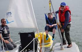
DISABLED_SAILING.jpg

DISABLED SAILING

The RNLI describes a very courageous disabled sailor on the programme in contrast to the decision of the Paralympics Committee to discard sailing from its programme.

NO PLACE FOR BEING POSH OR A FIGUREHEAD

Also discussed on THIS ISLAND NATION is the use of nautical descriptions in everyday language, such as 'posh,' being a 'figurehead' and 'flogging a dead horse."

Published in Island Nation

Dublin Bay

Dublin Bay on the east coast of Ireland stretches over seven kilometres, from Howth Head on its northern tip to Dalkey Island in the south. It's a place most Dubliners simply take for granted, and one of the capital's least visited places. But there's more going on out there than you'd imagine.

The biggest boating centre is at Dun Laoghaire Harbour on the Bay's south shore that is home to over 1,500 pleasure craft, four waterfront yacht clubs and Ireland's largest marina.

The bay is rather shallow with many sandbanks and rocky outcrops, and was notorious in the past for shipwrecks, especially when the wind was from the east. Until modern times, many ships and their passengers were lost along the treacherous coastline from Howth to Dun Laoghaire, less than a kilometre from shore.

The Bay is a C-shaped inlet of the Irish Sea and is about 10 kilometres wide along its north-south base, and 7 km in length to its apex at the centre of the city of Dublin; stretching from Howth Head in the north to Dalkey Point in the south. North Bull Island is situated in the northwest part of the bay, where one of two major inshore sandbanks lie, and features a 5 km long sandy beach, Dollymount Strand, fronting an internationally recognised wildfowl reserve. Many of the rivers of Dublin reach the Irish Sea at Dublin Bay: the River Liffey, with the River Dodder flow received less than 1 km inland, River Tolka, and various smaller rivers and streams.

Dublin Bay FAQs

There are approximately ten beaches and bathing spots around Dublin Bay: Dollymount Strand; Forty Foot Bathing Place; Half Moon bathing spot; Merrion Strand; Bull Wall; Sandycove Beach; Sandymount Strand; Seapoint; Shelley Banks; Sutton, Burrow Beach

There are slipways on the north side of Dublin Bay at Clontarf, Sutton and on the southside at Dun Laoghaire Harbour, and in Dalkey at Coliemore and Bulloch Harbours.

Dublin Bay is administered by a number of Government Departments, three local authorities and several statutory agencies. Dublin Port Company is in charge of navigation on the Bay.

Dublin Bay is approximately 70 sq kilometres or 7,000 hectares. The Bay is about 10 kilometres wide along its north-south base, and seven km in length east-west to its peak at the centre of the city of Dublin; stretching from Howth Head in the north to Dalkey Point in the south.

Dun Laoghaire Harbour on the southside of the Bay has an East and West Pier, each one kilometre long; this is one of the largest human-made harbours in the world. There also piers or walls at the entrance to the River Liffey at Dublin city known as the Great North and South Walls. Other harbours on the Bay include Bulloch Harbour and Coliemore Harbours both at Dalkey.

There are two marinas on Dublin Bay. Ireland's largest marina with over 800 berths is on the southern shore at Dun Laoghaire Harbour. The other is at Poolbeg Yacht and Boat Club on the River Liffey close to Dublin City.

Car and passenger Ferries operate from Dublin Port to the UK, Isle of Man and France. A passenger ferry operates from Dun Laoghaire Harbour to Howth as well as providing tourist voyages around the bay.

Dublin Bay has two Islands. Bull Island at Clontarf and Dalkey Island on the southern shore of the Bay.

The River Liffey flows through Dublin city and into the Bay. Its tributaries include the River Dodder, the River Poddle and the River Camac.

Dollymount, Burrow and Seapoint beaches

Approximately 1,500 boats from small dinghies to motorboats to ocean-going yachts. The vast majority, over 1,000, are moored at Dun Laoghaire Harbour which is Ireland's boating capital.

In 1981, UNESCO recognised the importance of Dublin Bay by designating North Bull Island as a Biosphere because of its rare and internationally important habitats and species of wildlife. To support sustainable development, UNESCO’s concept of a Biosphere has evolved to include not just areas of ecological value but also the areas around them and the communities that live and work within these areas. There have since been additional international and national designations, covering much of Dublin Bay, to ensure the protection of its water quality and biodiversity. To fulfil these broader management aims for the ecosystem, the Biosphere was expanded in 2015. The Biosphere now covers Dublin Bay, reflecting its significant environmental, economic, cultural and tourism importance, and extends to over 300km² to include the bay, the shore and nearby residential areas.

On the Southside at Dun Laoghaire, there is the National Yacht Club, Royal St. George Yacht Club, Royal Irish Yacht Club and Dun Laoghaire Motor Yacht Club as well as Dublin Bay Sailing Club. In the city centre, there is Poolbeg Yacht and Boat Club. On the Northside of Dublin, there is Clontarf Yacht and Boat Club and Sutton Dinghy Club. While not on Dublin Bay, Howth Yacht Club is the major north Dublin Sailing centre.

© Afloat 2020