Menu

Ireland's sailing, boating & maritime magazine

Dublin Bay Boating News and Information

Displaying items by tag: UC42

With the Lusitania expedition in the news, Saturday's Irish Times presents a guide to some of Ireland's most interesting diving sites for all levels of experience.
Though Ireland can boast an abundance of shipwreck sites, a number of them are off-limits to anyone but the hardiest expert explorers, while others require a licence from the Department of Hertiage.
But open dives are still plenty, such as the wreck of UC-42 off Roches Point in Cork, which happens to lie in a popular diving range, and the Empire Hertiage, which lies 30km off the coast of Malin Head and is regarded as one of Ireland's best wreck dives.
Among the licenced dives, the HMS Vanguard - which was tragically sunk 19km east of Bray by its sister ship Iron Duke in 1875 - is a top contender, with the summer months providing astounding visibility of the ships 9in guns.
The Irish Times has more on the story HERE.

With the Lusitania expedition in the news, Saturday's Irish Times presents a guide to some of Ireland's most interesting diving sites for all levels of experience.

Though Ireland can boast an abundance of shipwreck sites, a number of them are off-limits to anyone but the hardiest expert explorers, while others require a licence from the Department of Hertiage.

But open dives are still plenty, such as the wreck of UC-42 off Roches Point in Cork, which happens to lie in a popular diving range, and the Empire Hertiage, which lies 30km off the coast of Malin Head and is regarded as one of Ireland's best wreck dives.

Among the licenced dives, the HMS Vanguard - which was tragically sunk 19km east of Bray by its sister ship Iron Duke in 1875 - is a top contender, with the summer months providing astounding visibility of the ship's 9in guns.

The Irish Times has more on the story HERE.

Published in Diving
Cork gardaí are investigating the looting of items from a First World War U-boat recently discovered off Roches Point.
The Irish Times reports that the submarine also appears to have been damaged by the illegal salvagers.
A spokesperson for the underwater archaeology unit of the Department of Arts, Heritage and the Gaeltacht confirmed that reports had come in from divers regarding disturbance of the wreck site - noting attempts to remove parts of the structure, and details of human remains.
Divers with the unit were expected to assess the site as soon as weather permits.
Items believed to have been taken include sailor's attire belonging to the crew of the 49-metre German vessel UC-42, which sank in 1917. The German embassy has indicated its "legitimate interest" in the preservation of the wreck.
The Irish Times has more on the story HERE.

Cork gardaí are investigating the looting of items from a First World War U-boat recently discovered off Roches Point.

The Irish Times reports that the submarine also appears to have been damaged by the illegal salvagers.

A spokesperson for the underwater archaeology unit of the Department of Arts, Heritage and the Gaeltacht confirmed that reports had come in from divers regarding disturbance of the wreck site - noting attempts to remove parts of the structure, and details of human remains.

Divers with the unit were expected to assess the site as soon as weather permits.

Items believed to have been taken include sailor's attire belonging to the crew of the 49-metre German vessel UC-42, which sank in 1917. The German embassy has indicated its "legitimate interest" in the preservation of the wreck.

The Irish Times has more on the story HERE.

Published in Coastal Notes

Scuba Divers have found a fully intact World War I U-Boat on the seabed just outside Cork harbour, some 93 years after it sank writes Timmy Carey.

During the First World War the menace provided by German U-Boats would prove deadly to the Allies and were responsible for sinking millions of tons of shipping; indeed German U-Boats almost changed the course of the war. Most allied ships sunk by U-boats were sunk by either torpedo, deck gunfire or explosives placed aboard the ship by U-boat crew. A smaller number of ships were also sunk by mine laying U-boats; one of these being UC42. On the 10th of September of 1917 UC42 was laying her deadly cargo of mines at the entrance to Cork harbour when a terrific explosion occurred which resulted in a grim death for all 27 German Submariners aboard.

As the submarine sank to the seabed the German submariners were trapped inside UC42, which would soon become their metal tomb.

On November  2nd of that year, hardhat divers from the Haulbowline dockyard dived the area and positively identified the U-boat as UC42, noting the stern damage to the submarine and the presence of the bodies of some of the German submariners. During 1918 the submarine was dived by Haulbowline and American divers in an effort to disarm all the mines and torpedoes still aboard, with USS Melville taking three of the mines. It was widely believed that in July 1919 divers using explosives from HMS Vernon torpedo school had destroyed the submarine with the remains being dispersed on the seabed by wire sweeps.

With the advent of scuba diving many divers have since searched for the scattered remains of UC42 around Cork harbour with no luck until a recent dive by two local divers Ian Kelleher and Niall O Regan descended a shot line to see the menacing sight of the hull of a German U-boat emerge from the shadows. Both divers were very surprised and ecstatic to find a fully intact World War I U-Boat in 27 meters of water just outside Cork harbour in good condition with little obvious explosive damage from the British naval dive team.

A local dive team of five divers had spent the previous 12 months carrying out a careful methodical search of the greater harbour area determined to find the remains of the submarine; their hard labours finally paying dividends when Niall and Ian identified the presence of the submarine. The dive team consisted of Ian Kelleher, Niall O Regan, Philip Johnston,  Eoin Mc Garry and Timmy Carey.

Over the past few weeks the divers have carefully and methodically videoed and photographed the Submarine and taken various measurements to record the wrecks' condition. Over a number of dives the dive team carefully cleaned the growth from the propeller and after some methodical cleaning found the U-Boats number UC42 stamped into it; positively identifying the submarine.

As the submarine is a war grave and contains the remains of so many young German submariners the dive team also laid a plaque of remembrance, which was erected near the submarines propellers; to act as a memorial to the German submariners forever entombed in UC42. The plaque was kindly donated to the dive team by John O' Mahony of Complete Signs.

IMG_60751

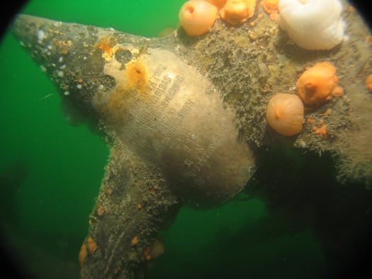
The image of the U-Boats propellor with the markings identifying the U-Boat. Photo: Timmy Carey

mine

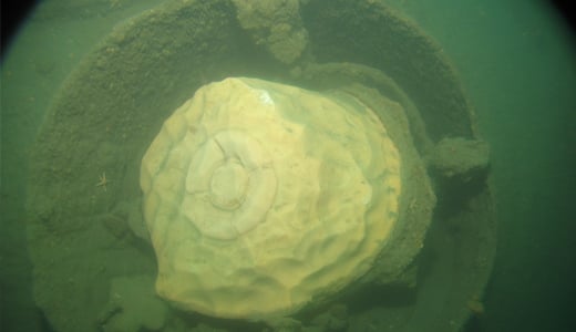
A badly decayed mine on UC42 still in the mine chute. Photo: Timmy Carey

RTE News Video clip here

Published in Diving

Dublin Bay

Dublin Bay on the east coast of Ireland stretches over seven kilometres, from Howth Head on its northern tip to Dalkey Island in the south. It's a place most Dubliners simply take for granted, and one of the capital's least visited places. But there's more going on out there than you'd imagine.

The biggest boating centre is at Dun Laoghaire Harbour on the Bay's south shore that is home to over 1,500 pleasure craft, four waterfront yacht clubs and Ireland's largest marina.

The bay is rather shallow with many sandbanks and rocky outcrops, and was notorious in the past for shipwrecks, especially when the wind was from the east. Until modern times, many ships and their passengers were lost along the treacherous coastline from Howth to Dun Laoghaire, less than a kilometre from shore.

The Bay is a C-shaped inlet of the Irish Sea and is about 10 kilometres wide along its north-south base, and 7 km in length to its apex at the centre of the city of Dublin; stretching from Howth Head in the north to Dalkey Point in the south. North Bull Island is situated in the northwest part of the bay, where one of two major inshore sandbanks lie, and features a 5 km long sandy beach, Dollymount Strand, fronting an internationally recognised wildfowl reserve. Many of the rivers of Dublin reach the Irish Sea at Dublin Bay: the River Liffey, with the River Dodder flow received less than 1 km inland, River Tolka, and various smaller rivers and streams.

Dublin Bay FAQs

There are approximately ten beaches and bathing spots around Dublin Bay: Dollymount Strand; Forty Foot Bathing Place; Half Moon bathing spot; Merrion Strand; Bull Wall; Sandycove Beach; Sandymount Strand; Seapoint; Shelley Banks; Sutton, Burrow Beach

There are slipways on the north side of Dublin Bay at Clontarf, Sutton and on the southside at Dun Laoghaire Harbour, and in Dalkey at Coliemore and Bulloch Harbours.

Dublin Bay is administered by a number of Government Departments, three local authorities and several statutory agencies. Dublin Port Company is in charge of navigation on the Bay.

Dublin Bay is approximately 70 sq kilometres or 7,000 hectares. The Bay is about 10 kilometres wide along its north-south base, and seven km in length east-west to its peak at the centre of the city of Dublin; stretching from Howth Head in the north to Dalkey Point in the south.

Dun Laoghaire Harbour on the southside of the Bay has an East and West Pier, each one kilometre long; this is one of the largest human-made harbours in the world. There also piers or walls at the entrance to the River Liffey at Dublin city known as the Great North and South Walls. Other harbours on the Bay include Bulloch Harbour and Coliemore Harbours both at Dalkey.

There are two marinas on Dublin Bay. Ireland's largest marina with over 800 berths is on the southern shore at Dun Laoghaire Harbour. The other is at Poolbeg Yacht and Boat Club on the River Liffey close to Dublin City.

Car and passenger Ferries operate from Dublin Port to the UK, Isle of Man and France. A passenger ferry operates from Dun Laoghaire Harbour to Howth as well as providing tourist voyages around the bay.

Dublin Bay has two Islands. Bull Island at Clontarf and Dalkey Island on the southern shore of the Bay.

The River Liffey flows through Dublin city and into the Bay. Its tributaries include the River Dodder, the River Poddle and the River Camac.

Dollymount, Burrow and Seapoint beaches

Approximately 1,500 boats from small dinghies to motorboats to ocean-going yachts. The vast majority, over 1,000, are moored at Dun Laoghaire Harbour which is Ireland's boating capital.

In 1981, UNESCO recognised the importance of Dublin Bay by designating North Bull Island as a Biosphere because of its rare and internationally important habitats and species of wildlife. To support sustainable development, UNESCO’s concept of a Biosphere has evolved to include not just areas of ecological value but also the areas around them and the communities that live and work within these areas. There have since been additional international and national designations, covering much of Dublin Bay, to ensure the protection of its water quality and biodiversity. To fulfil these broader management aims for the ecosystem, the Biosphere was expanded in 2015. The Biosphere now covers Dublin Bay, reflecting its significant environmental, economic, cultural and tourism importance, and extends to over 300km² to include the bay, the shore and nearby residential areas.

On the Southside at Dun Laoghaire, there is the National Yacht Club, Royal St. George Yacht Club, Royal Irish Yacht Club and Dun Laoghaire Motor Yacht Club as well as Dublin Bay Sailing Club. In the city centre, there is Poolbeg Yacht and Boat Club. On the Northside of Dublin, there is Clontarf Yacht and Boat Club and Sutton Dinghy Club. While not on Dublin Bay, Howth Yacht Club is the major north Dublin Sailing centre.

© Afloat 2020