Menu

Ireland's sailing, boating & maritime magazine

Dublin Bay Boating News and Information

Displaying items by tag: UEFA EURO 2016

#FerrytoMed – Former Cork-Swansea ferry Julia of the Fastnet Line that closed in 2011, is to enter service in July on a Mediterranean service between France and Corsica, writes Jehan Ashmore.

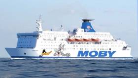
As previously reported on Afloat.ie, the Julia (1982/22,161gt) which operated the Ireland-Wales link for only two seasons was re-sold to Italian operator Moby Lines, and is to enter a new Nice-Bastia (Corsica) service. This follows an interim career for Dutch owners as the Wind Perfection that provided floating accommodation in the Irish Sea for workers during construction of a wind-farm.

Under her new owners as Moby Zazà, the 1,850 passenger/325 car/30 truck ferry underwent a drydocking in Liverno to include the company’s customary ‘cartoon’ livery depicting Warner Bros. Looney Tunes characters. She will enter the Nice-Bastia service next month, though the new route was only launched at the beginning of this month.

Commenting to Afloat, a spokesperson for Moby Lines said that in the meantime the route is currently served by Moby Corse (1978/14,399gt). In recent days due to the football matches of Euro 2016 held at the Allianz Arena Nice, Moby Lines have informed customers to expect increased traffic and congestion in the city.

The launch of the Nice-Bastia service which is to be operated year round is in direct competition with established operator, Corsica-Sardinia Ferries. Likewise of the new entrant they have a ferry network that includes routes to and from the France and also the Italian mainland.  

Sailings times connecting the Cote D’Azur and the north-eastern Corsican port are scheduled for 7 hours 30 minutes during the day while overnight crossings will take 9 hours. Moby Zasa was launched as Olau Britannia to serve a first career sailing between Sheerness, UK and Vlissengen, Netherlands along with Olau Hollandia. 

In regards to Moby Corse (as alluded above) this ferry also originally began a career sailing in the North Sea as the Dana Anglia. She served DFDS Seaways service linking England and Denmark and notably the ferry was used as the setting for a 1980’s soap opera TV series ‘Triangle’.

In much more recent times she sailed for Brittany Ferries as Pont-l'Abbé on the Plymouth-Roscoff run. Like numerous northern based European ferries, the final years of these veteran ships are mostly to be seen plying the Mediterranean.

Published in Ferry

Dublin Bay

Dublin Bay on the east coast of Ireland stretches over seven kilometres, from Howth Head on its northern tip to Dalkey Island in the south. It's a place most Dubliners simply take for granted, and one of the capital's least visited places. But there's more going on out there than you'd imagine.

The biggest boating centre is at Dun Laoghaire Harbour on the Bay's south shore that is home to over 1,500 pleasure craft, four waterfront yacht clubs and Ireland's largest marina.

The bay is rather shallow with many sandbanks and rocky outcrops, and was notorious in the past for shipwrecks, especially when the wind was from the east. Until modern times, many ships and their passengers were lost along the treacherous coastline from Howth to Dun Laoghaire, less than a kilometre from shore.

The Bay is a C-shaped inlet of the Irish Sea and is about 10 kilometres wide along its north-south base, and 7 km in length to its apex at the centre of the city of Dublin; stretching from Howth Head in the north to Dalkey Point in the south. North Bull Island is situated in the northwest part of the bay, where one of two major inshore sandbanks lie, and features a 5 km long sandy beach, Dollymount Strand, fronting an internationally recognised wildfowl reserve. Many of the rivers of Dublin reach the Irish Sea at Dublin Bay: the River Liffey, with the River Dodder flow received less than 1 km inland, River Tolka, and various smaller rivers and streams.

Dublin Bay FAQs

There are approximately ten beaches and bathing spots around Dublin Bay: Dollymount Strand; Forty Foot Bathing Place; Half Moon bathing spot; Merrion Strand; Bull Wall; Sandycove Beach; Sandymount Strand; Seapoint; Shelley Banks; Sutton, Burrow Beach

There are slipways on the north side of Dublin Bay at Clontarf, Sutton and on the southside at Dun Laoghaire Harbour, and in Dalkey at Coliemore and Bulloch Harbours.

Dublin Bay is administered by a number of Government Departments, three local authorities and several statutory agencies. Dublin Port Company is in charge of navigation on the Bay.

Dublin Bay is approximately 70 sq kilometres or 7,000 hectares. The Bay is about 10 kilometres wide along its north-south base, and seven km in length east-west to its peak at the centre of the city of Dublin; stretching from Howth Head in the north to Dalkey Point in the south.

Dun Laoghaire Harbour on the southside of the Bay has an East and West Pier, each one kilometre long; this is one of the largest human-made harbours in the world. There also piers or walls at the entrance to the River Liffey at Dublin city known as the Great North and South Walls. Other harbours on the Bay include Bulloch Harbour and Coliemore Harbours both at Dalkey.

There are two marinas on Dublin Bay. Ireland's largest marina with over 800 berths is on the southern shore at Dun Laoghaire Harbour. The other is at Poolbeg Yacht and Boat Club on the River Liffey close to Dublin City.

Car and passenger Ferries operate from Dublin Port to the UK, Isle of Man and France. A passenger ferry operates from Dun Laoghaire Harbour to Howth as well as providing tourist voyages around the bay.

Dublin Bay has two Islands. Bull Island at Clontarf and Dalkey Island on the southern shore of the Bay.

The River Liffey flows through Dublin city and into the Bay. Its tributaries include the River Dodder, the River Poddle and the River Camac.

Dollymount, Burrow and Seapoint beaches

Approximately 1,500 boats from small dinghies to motorboats to ocean-going yachts. The vast majority, over 1,000, are moored at Dun Laoghaire Harbour which is Ireland's boating capital.

In 1981, UNESCO recognised the importance of Dublin Bay by designating North Bull Island as a Biosphere because of its rare and internationally important habitats and species of wildlife. To support sustainable development, UNESCO’s concept of a Biosphere has evolved to include not just areas of ecological value but also the areas around them and the communities that live and work within these areas. There have since been additional international and national designations, covering much of Dublin Bay, to ensure the protection of its water quality and biodiversity. To fulfil these broader management aims for the ecosystem, the Biosphere was expanded in 2015. The Biosphere now covers Dublin Bay, reflecting its significant environmental, economic, cultural and tourism importance, and extends to over 300km² to include the bay, the shore and nearby residential areas.

On the Southside at Dun Laoghaire, there is the National Yacht Club, Royal St. George Yacht Club, Royal Irish Yacht Club and Dun Laoghaire Motor Yacht Club as well as Dublin Bay Sailing Club. In the city centre, there is Poolbeg Yacht and Boat Club. On the Northside of Dublin, there is Clontarf Yacht and Boat Club and Sutton Dinghy Club. While not on Dublin Bay, Howth Yacht Club is the major north Dublin Sailing centre.

© Afloat 2020