Menu

Ireland's sailing, boating & maritime magazine

Dublin Bay Boating News and Information

Displaying items by tag: Velvet Crab

#Fishing - Marine Minister Michael Creed signed into law conservation measures concerning Irish velvet crab stocks as he hosted the 12th meeting of the National Inshore Fisheries Forum (NIFF) today, Wednesday 27 September.

The Inshore Fisheries Forum structures, which include the NIFF and six Regional Inshore Fisheries Forums (RIFFs), were established in 2014 to foster stakeholder-led development of proposals for the inshore fishing sector.

As well as moved to protect Irish velvet crab, the minister also introduced measures to regulate fishing activities affecting Natura 2000 sites at Hook Head and the Saltee Islands.

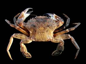
Regulations signed by Minister Creed today will introduce a Minimum Conservation Reference Size (MCRS) of 65mm for velvet crab that will apply to Irish sea fishing boats from 1 January 2018.

This measure was initially developed by the West Regional Inshore Fisheries Forum (RIFF) with advice from the Marine Institute. The proposal was brought to the minister last year by the NIFF, and a public consultation on the measure was held at the end of 2016.

Velvet crab are fished all year, but mainly in the March to October period, and they are predominantly a by-catch in the lobster fishery. Landings of velvet crab into Ireland were 406 tonnes in 2015, higher than any year since 2004, and were valued at just under €808,000. Over 80% of velvet crabs are landed by vessels less than 10 metres in length.

Additionally, a Fisheries Natura Declaration signed by Minister Creed today will restrict fishing using dredge and trawling gear for scallop fishing to protect certain sensitive habitats in Natura 2000 conservation sites off the southeast coast of Wexford from 30 November.

The Natura 2000 sites include the Hook Head and Saltee Islands SACs (Special Areas of Conservation). The declaration also sets down monitoring and notification requirements for boats fishing using dredge and trawling gear within these habitats.

These gear and monitoring measures were developed through industry members working with the Marine Institute and Bord Iascaigh Mhara (BIM) to address risks to sensitive habitats in the Hook Head and Saltee Islands SACs. The risks were identified by the Marine Institute in a 2014 risk assessment report of sea-fishing activities in Natura 2000 sites in the Irish Sea.

Industry members – including individual scallop fishermen, members of the Southeast RIFF and representatives of the Irish South and East Fish Producers Organisation (ISEFPO) – met with the Marine Institute and BIM through 2015 and 2016 to develop risk mitigation proposals for the fishery. A public consultation on the resulting Mitigation Response Plan was carried out in 2016.

These measures are being introduced following full consultation with the Inshore Fisheries Forum structures.

“Heading into their third year, the forums have taken a lead in tackling conservation issues and changing practices with a view to long-term sustainability,” said Minister Creed. “I welcome the support these measures have received from the Forums which reflects the mature approach this sector is taking in dealing with its own challenges.”

Minister Creed and the NIFF discussed the implementation of the new measures and the status of other measures under review for important stocks such as lobster, brown crab and razor clams.

The minister also discussed the impact of Brexit on the fishing sector and the UK’s intention to withdraw from the London Fisheries Convention, which governs access to waters inside the 12-mile limit.

Commenting on issues arising for the sector from Brexit, Minister Creed noted: “While the implications of Brexit are far from clear at this point in time, I will continue to highlight Irish fisheries concerns on the EU agenda and work with other impacted EU member states and the Barnier team to ensure that fisheries are not isolated in the overall negotiations on a new EU/UK relationship.”

Published in Fishing

Dublin Bay

Dublin Bay on the east coast of Ireland stretches over seven kilometres, from Howth Head on its northern tip to Dalkey Island in the south. It's a place most Dubliners simply take for granted, and one of the capital's least visited places. But there's more going on out there than you'd imagine.

The biggest boating centre is at Dun Laoghaire Harbour on the Bay's south shore that is home to over 1,500 pleasure craft, four waterfront yacht clubs and Ireland's largest marina.

The bay is rather shallow with many sandbanks and rocky outcrops, and was notorious in the past for shipwrecks, especially when the wind was from the east. Until modern times, many ships and their passengers were lost along the treacherous coastline from Howth to Dun Laoghaire, less than a kilometre from shore.

The Bay is a C-shaped inlet of the Irish Sea and is about 10 kilometres wide along its north-south base, and 7 km in length to its apex at the centre of the city of Dublin; stretching from Howth Head in the north to Dalkey Point in the south. North Bull Island is situated in the northwest part of the bay, where one of two major inshore sandbanks lie, and features a 5 km long sandy beach, Dollymount Strand, fronting an internationally recognised wildfowl reserve. Many of the rivers of Dublin reach the Irish Sea at Dublin Bay: the River Liffey, with the River Dodder flow received less than 1 km inland, River Tolka, and various smaller rivers and streams.

Dublin Bay FAQs

There are approximately ten beaches and bathing spots around Dublin Bay: Dollymount Strand; Forty Foot Bathing Place; Half Moon bathing spot; Merrion Strand; Bull Wall; Sandycove Beach; Sandymount Strand; Seapoint; Shelley Banks; Sutton, Burrow Beach

There are slipways on the north side of Dublin Bay at Clontarf, Sutton and on the southside at Dun Laoghaire Harbour, and in Dalkey at Coliemore and Bulloch Harbours.

Dublin Bay is administered by a number of Government Departments, three local authorities and several statutory agencies. Dublin Port Company is in charge of navigation on the Bay.

Dublin Bay is approximately 70 sq kilometres or 7,000 hectares. The Bay is about 10 kilometres wide along its north-south base, and seven km in length east-west to its peak at the centre of the city of Dublin; stretching from Howth Head in the north to Dalkey Point in the south.

Dun Laoghaire Harbour on the southside of the Bay has an East and West Pier, each one kilometre long; this is one of the largest human-made harbours in the world. There also piers or walls at the entrance to the River Liffey at Dublin city known as the Great North and South Walls. Other harbours on the Bay include Bulloch Harbour and Coliemore Harbours both at Dalkey.

There are two marinas on Dublin Bay. Ireland's largest marina with over 800 berths is on the southern shore at Dun Laoghaire Harbour. The other is at Poolbeg Yacht and Boat Club on the River Liffey close to Dublin City.

Car and passenger Ferries operate from Dublin Port to the UK, Isle of Man and France. A passenger ferry operates from Dun Laoghaire Harbour to Howth as well as providing tourist voyages around the bay.

Dublin Bay has two Islands. Bull Island at Clontarf and Dalkey Island on the southern shore of the Bay.

The River Liffey flows through Dublin city and into the Bay. Its tributaries include the River Dodder, the River Poddle and the River Camac.

Dollymount, Burrow and Seapoint beaches

Approximately 1,500 boats from small dinghies to motorboats to ocean-going yachts. The vast majority, over 1,000, are moored at Dun Laoghaire Harbour which is Ireland's boating capital.

In 1981, UNESCO recognised the importance of Dublin Bay by designating North Bull Island as a Biosphere because of its rare and internationally important habitats and species of wildlife. To support sustainable development, UNESCO’s concept of a Biosphere has evolved to include not just areas of ecological value but also the areas around them and the communities that live and work within these areas. There have since been additional international and national designations, covering much of Dublin Bay, to ensure the protection of its water quality and biodiversity. To fulfil these broader management aims for the ecosystem, the Biosphere was expanded in 2015. The Biosphere now covers Dublin Bay, reflecting its significant environmental, economic, cultural and tourism importance, and extends to over 300km² to include the bay, the shore and nearby residential areas.

On the Southside at Dun Laoghaire, there is the National Yacht Club, Royal St. George Yacht Club, Royal Irish Yacht Club and Dun Laoghaire Motor Yacht Club as well as Dublin Bay Sailing Club. In the city centre, there is Poolbeg Yacht and Boat Club. On the Northside of Dublin, there is Clontarf Yacht and Boat Club and Sutton Dinghy Club. While not on Dublin Bay, Howth Yacht Club is the major north Dublin Sailing centre.

© Afloat 2020