Menu

Ireland's sailing, boating & maritime magazine

Dublin Bay Boating News and Information

Displaying items by tag: Virtual

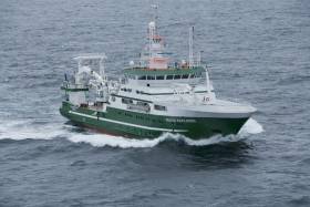
#RVCelticExplorer - Pay a visit on board Ireland’s national marine research vessel wherever you are, thanks to a new immersive 360-degree virtual tour of the RV Celtic Explorer courtesy of the Marine Institute.

Conor Purcell writes in New Scientist on the top attractions aboard the busy marine science vessel, including its wet and dry labs, the tech-filled bridge, its sensor-studded drop keel and even the chief scientist’s cabin.

The RV Celtic Explorer most recently returned from its ‘health check’ of the Atlantic Ocean, which suggests a greater penetration of CFCs in the deeper ocean since the late 1990s.

If this tour whets your appetite, you can still pay a virtual visit to Hook Lighthouse among other coastal locations in Ireland.

Published in Marine Science
#IRISH SEA – The Irish Sea Offshore Racing Association (ISORA) is pushing ahead with plans to incorporate 'virtual' marks into at least some of it's offshore programme in 2012. Afloat.ie reported on the prospect last September.

The moves come as the offshore body goes from strength to strength on the Irish Sea, recruiting more boats to venture out of Dublin Bay and to try longer distance races. It is a reversal of fortunes for offshore sailing that had been vitally wiped out just a few years ago.

The idea for the new marks sprung from last years' Lyver Race from Liverpool Yacht Club where a virtual mark was successfully used as a mark on the course (i.e. coordinates only).

The problem for ISORA though, with the exception of M2 buoy, is most of the marks used in ISORA raeces are within five to seven miles of the Irish coast and there are no marks off the Welsh coast.

Using virtual marks further off the coast would greatly help in setting courses that are not just long reaching legs. The day races, particularly from Dun Laoghaire could be far more interesting.

One of the problems about using the virtual marks though is the question of "how do you ensure that all boats have rounded the mark?"

The boats in the Lyver race had trackers fitted but ISORA commodore Peter Ryan says his experience of watching several boats round the 'mark' was that they tended to take it 'wide'.

Ryan is looking into the possibility of "obtaining" a set of trackers that could be used for all ISORA races.

Another suggestion is that a photograph could be taken on a mobile phone of the boat's GPS display at the time of the rounding. The photo would then be sent by SMS to the race office as part of the normal finish time declaration.

The feasibility of such a move is just one of the items on the agenda at the association's agm on November 19th at the National Yacht Club in Dun Laoghaire, a highlight of the offshore year.

Published in ISORA

Taking a lead from this year's Lyver offshore sailing race, when Liverpool Yacht Club used a "virtual" waypoint as a mark on the course, ISORA may include this type of mark in future races, that's according to Commodore Peter Ryan. His comments come in a plea to members for feedback before the 2012 ISORA calendar is set at the ISORA agm on November 19th. Virtual marks would be a means to ensure that the offshore fleet get true upwind legs and still have reasonable length races.

It would, says Ryan of Dun Laoghaire's National Yacht Club,  also facilitate the shortening of the day races.  'We have been around Rockabill so often over the last few years that the bird life there think we are residents!' he adds.

Published in ISORA
Over 4,000 skippers have already signed up to the Virtual Race Game for the Sevenstar Round Britain and Ireland Race which starts from Cowes, Isle of Wight on Monday 23rd August, so there's still plenty of time to sign up and prepare yourself for one of the toughest races on the sailing calendar. We've no Irish entries in the actual race so we might as well try and win this one?

Go to the Royal Ocean Racing Club's race minisite and click on the Virtual Race button to get started: http://sevenstar.rorc.org/

Published in Rd Britain & Ireland

Dublin Bay

Dublin Bay on the east coast of Ireland stretches over seven kilometres, from Howth Head on its northern tip to Dalkey Island in the south. It's a place most Dubliners simply take for granted, and one of the capital's least visited places. But there's more going on out there than you'd imagine.

The biggest boating centre is at Dun Laoghaire Harbour on the Bay's south shore that is home to over 1,500 pleasure craft, four waterfront yacht clubs and Ireland's largest marina.

The bay is rather shallow with many sandbanks and rocky outcrops, and was notorious in the past for shipwrecks, especially when the wind was from the east. Until modern times, many ships and their passengers were lost along the treacherous coastline from Howth to Dun Laoghaire, less than a kilometre from shore.

The Bay is a C-shaped inlet of the Irish Sea and is about 10 kilometres wide along its north-south base, and 7 km in length to its apex at the centre of the city of Dublin; stretching from Howth Head in the north to Dalkey Point in the south. North Bull Island is situated in the northwest part of the bay, where one of two major inshore sandbanks lie, and features a 5 km long sandy beach, Dollymount Strand, fronting an internationally recognised wildfowl reserve. Many of the rivers of Dublin reach the Irish Sea at Dublin Bay: the River Liffey, with the River Dodder flow received less than 1 km inland, River Tolka, and various smaller rivers and streams.

Dublin Bay FAQs

There are approximately ten beaches and bathing spots around Dublin Bay: Dollymount Strand; Forty Foot Bathing Place; Half Moon bathing spot; Merrion Strand; Bull Wall; Sandycove Beach; Sandymount Strand; Seapoint; Shelley Banks; Sutton, Burrow Beach

There are slipways on the north side of Dublin Bay at Clontarf, Sutton and on the southside at Dun Laoghaire Harbour, and in Dalkey at Coliemore and Bulloch Harbours.

Dublin Bay is administered by a number of Government Departments, three local authorities and several statutory agencies. Dublin Port Company is in charge of navigation on the Bay.

Dublin Bay is approximately 70 sq kilometres or 7,000 hectares. The Bay is about 10 kilometres wide along its north-south base, and seven km in length east-west to its peak at the centre of the city of Dublin; stretching from Howth Head in the north to Dalkey Point in the south.

Dun Laoghaire Harbour on the southside of the Bay has an East and West Pier, each one kilometre long; this is one of the largest human-made harbours in the world. There also piers or walls at the entrance to the River Liffey at Dublin city known as the Great North and South Walls. Other harbours on the Bay include Bulloch Harbour and Coliemore Harbours both at Dalkey.

There are two marinas on Dublin Bay. Ireland's largest marina with over 800 berths is on the southern shore at Dun Laoghaire Harbour. The other is at Poolbeg Yacht and Boat Club on the River Liffey close to Dublin City.

Car and passenger Ferries operate from Dublin Port to the UK, Isle of Man and France. A passenger ferry operates from Dun Laoghaire Harbour to Howth as well as providing tourist voyages around the bay.

Dublin Bay has two Islands. Bull Island at Clontarf and Dalkey Island on the southern shore of the Bay.

The River Liffey flows through Dublin city and into the Bay. Its tributaries include the River Dodder, the River Poddle and the River Camac.

Dollymount, Burrow and Seapoint beaches

Approximately 1,500 boats from small dinghies to motorboats to ocean-going yachts. The vast majority, over 1,000, are moored at Dun Laoghaire Harbour which is Ireland's boating capital.

In 1981, UNESCO recognised the importance of Dublin Bay by designating North Bull Island as a Biosphere because of its rare and internationally important habitats and species of wildlife. To support sustainable development, UNESCO’s concept of a Biosphere has evolved to include not just areas of ecological value but also the areas around them and the communities that live and work within these areas. There have since been additional international and national designations, covering much of Dublin Bay, to ensure the protection of its water quality and biodiversity. To fulfil these broader management aims for the ecosystem, the Biosphere was expanded in 2015. The Biosphere now covers Dublin Bay, reflecting its significant environmental, economic, cultural and tourism importance, and extends to over 300km² to include the bay, the shore and nearby residential areas.

On the Southside at Dun Laoghaire, there is the National Yacht Club, Royal St. George Yacht Club, Royal Irish Yacht Club and Dun Laoghaire Motor Yacht Club as well as Dublin Bay Sailing Club. In the city centre, there is Poolbeg Yacht and Boat Club. On the Northside of Dublin, there is Clontarf Yacht and Boat Club and Sutton Dinghy Club. While not on Dublin Bay, Howth Yacht Club is the major north Dublin Sailing centre.

© Afloat 2020