Menu

Ireland's sailing, boating & maritime magazine

Dublin Bay Boating News and Information

Displaying items by tag: Weever

Beachgoers around Munster have been warned to watch where they step after numerous sightings of a venomous fish that lurks in the sand, as the Irish Examiner reports.

Lesser weevers are small fish, only 15cm in length, but their stinging spines pack a painful wallop — and in rare cases can be potentially fatal.

Kevin Flannery of Dingle OceanWorld says weevers generally avoid spots where people congregate on beaches, but may be encountered off the beaten track — so wearing footwear, even flip-flops, is a must.

And if you’re unlucky enough to step on one, get the affected area under hot water — up to 40 degrees if possible — to help break down the venom. The Irish Examiner has more on the story HERE.

Munster is also the place to be to see swarms of jellyfish that have turned up along the Cork coastline in recent days, according to the Irish Mirror.

Thousands of what are believed to be moon jellyfish have been spotted from Garretstown to Cobh in Cork Harbour, likely attracted by warmer waters to feed on their usual diet of plankton, molluscs — and other jellyfish.

Published in Coastal Notes
Tagged under

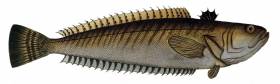
As we approach the Bank Holiday Weekend, CEO of Irish Water Safety John Leech reminds swimmers, surfers and all beach users of the little sandy coloured fish that lives in the sea on our beaches. It spends most of the time buried under the sand with just its venomous black dorsal fin showing above the sandy bottom. It grows to a maximum length of 15 centimetres. They are found all round the Irish coast but only in sandy areas where the water is warm and shallow close to the mean low water tide line. There is a new moon on Tuesday and that will give us spring tides which means that swimmers and surfers will have to venture further out on the beach in to the area where the Weever live.

We advise the public to avoid swimming approximately one hour to two hours either side of low water to reduce the risk of stepping on them until the tides reverts back towards neaps later next week. The public should wear flip flops or sandals when walking on the beach close to Low Water.

Should a bather step on a weever fish then the pain is excruciating as the spines embed into the human flesh and discharge their poison.

The pain is at its most intense for the first two hours when the foot normally goes red and swells up, and then it may feel numb until the following day with irritation and pain that may last for up to two weeks. Sometimes, the spine breaks off in the foot and it will cause discomfort until it is removed. You won't see a Weever fish easily but you will know it's there if you are unfortunate enough to stand on one since its back has a defensive sting mechanism. The sting can be very painful but will not cause permanent damage.

One danger is that it can cause anaphylactic shock or allergic reaction to those who are vulnerable and people have been known to die.

People who have been stung could take painkillers and if they develop an allergic reaction to the sting, a course of antihistamines is recommended
Seek assistance from a lifeguard who are all qualified first aiders.
Aspivenin syringes can painlessly draw out poison from the wound.
If you are away from a beach with lifeguard support, as soon as possible get the area which has been stung, invariably the foot, into hot water, this increases the blood flow which assists natural cleaning and healing, the heat also helps to break down the poison. The water needs to be over 40 degrees Celsius to be of any benefit in breaking down the poison.

The poison is a type of protein and is heat labile. Most reports of stings occur during the month of August. This does not mean that this fish are particularly prevalent inshore during this month but merely reflects the greater numbers of bathers as the sea temperature reaches the highest of the year. The only death on record after someone being stung by a Weever occurred as long ago as 1927, when an angler suffered multiple stings whilst fishing off Dungeness in the UK.

The mouth itself is in an unusual position on its head, oblique and almost vertical and contains some of the most sharp and vicious looking teeth in the undersea world. Luckily it only reaches about 15 cm long.
The Weever has to be quick to catch is prey though, and for half a metre it has a fair turn of speed, before sinking to the sea floor. This fish does not have a swim bladder, the device used by most bony fish to keep buoyant.

The species found in shallow waters is called the Lesser Weever with the scientific name of Echiichthys vipera. The word 'weever' was first found used in the English language during the 17th century and comes from the Old northern French word 'wivre'.

Published in Marine Warning
Tagged under

Dublin Bay

Dublin Bay on the east coast of Ireland stretches over seven kilometres, from Howth Head on its northern tip to Dalkey Island in the south. It's a place most Dubliners simply take for granted, and one of the capital's least visited places. But there's more going on out there than you'd imagine.

The biggest boating centre is at Dun Laoghaire Harbour on the Bay's south shore that is home to over 1,500 pleasure craft, four waterfront yacht clubs and Ireland's largest marina.

The bay is rather shallow with many sandbanks and rocky outcrops, and was notorious in the past for shipwrecks, especially when the wind was from the east. Until modern times, many ships and their passengers were lost along the treacherous coastline from Howth to Dun Laoghaire, less than a kilometre from shore.

The Bay is a C-shaped inlet of the Irish Sea and is about 10 kilometres wide along its north-south base, and 7 km in length to its apex at the centre of the city of Dublin; stretching from Howth Head in the north to Dalkey Point in the south. North Bull Island is situated in the northwest part of the bay, where one of two major inshore sandbanks lie, and features a 5 km long sandy beach, Dollymount Strand, fronting an internationally recognised wildfowl reserve. Many of the rivers of Dublin reach the Irish Sea at Dublin Bay: the River Liffey, with the River Dodder flow received less than 1 km inland, River Tolka, and various smaller rivers and streams.

Dublin Bay FAQs

There are approximately ten beaches and bathing spots around Dublin Bay: Dollymount Strand; Forty Foot Bathing Place; Half Moon bathing spot; Merrion Strand; Bull Wall; Sandycove Beach; Sandymount Strand; Seapoint; Shelley Banks; Sutton, Burrow Beach

There are slipways on the north side of Dublin Bay at Clontarf, Sutton and on the southside at Dun Laoghaire Harbour, and in Dalkey at Coliemore and Bulloch Harbours.

Dublin Bay is administered by a number of Government Departments, three local authorities and several statutory agencies. Dublin Port Company is in charge of navigation on the Bay.

Dublin Bay is approximately 70 sq kilometres or 7,000 hectares. The Bay is about 10 kilometres wide along its north-south base, and seven km in length east-west to its peak at the centre of the city of Dublin; stretching from Howth Head in the north to Dalkey Point in the south.

Dun Laoghaire Harbour on the southside of the Bay has an East and West Pier, each one kilometre long; this is one of the largest human-made harbours in the world. There also piers or walls at the entrance to the River Liffey at Dublin city known as the Great North and South Walls. Other harbours on the Bay include Bulloch Harbour and Coliemore Harbours both at Dalkey.

There are two marinas on Dublin Bay. Ireland's largest marina with over 800 berths is on the southern shore at Dun Laoghaire Harbour. The other is at Poolbeg Yacht and Boat Club on the River Liffey close to Dublin City.

Car and passenger Ferries operate from Dublin Port to the UK, Isle of Man and France. A passenger ferry operates from Dun Laoghaire Harbour to Howth as well as providing tourist voyages around the bay.

Dublin Bay has two Islands. Bull Island at Clontarf and Dalkey Island on the southern shore of the Bay.

The River Liffey flows through Dublin city and into the Bay. Its tributaries include the River Dodder, the River Poddle and the River Camac.

Dollymount, Burrow and Seapoint beaches

Approximately 1,500 boats from small dinghies to motorboats to ocean-going yachts. The vast majority, over 1,000, are moored at Dun Laoghaire Harbour which is Ireland's boating capital.

In 1981, UNESCO recognised the importance of Dublin Bay by designating North Bull Island as a Biosphere because of its rare and internationally important habitats and species of wildlife. To support sustainable development, UNESCO’s concept of a Biosphere has evolved to include not just areas of ecological value but also the areas around them and the communities that live and work within these areas. There have since been additional international and national designations, covering much of Dublin Bay, to ensure the protection of its water quality and biodiversity. To fulfil these broader management aims for the ecosystem, the Biosphere was expanded in 2015. The Biosphere now covers Dublin Bay, reflecting its significant environmental, economic, cultural and tourism importance, and extends to over 300km² to include the bay, the shore and nearby residential areas.

On the Southside at Dun Laoghaire, there is the National Yacht Club, Royal St. George Yacht Club, Royal Irish Yacht Club and Dun Laoghaire Motor Yacht Club as well as Dublin Bay Sailing Club. In the city centre, there is Poolbeg Yacht and Boat Club. On the Northside of Dublin, there is Clontarf Yacht and Boat Club and Sutton Dinghy Club. While not on Dublin Bay, Howth Yacht Club is the major north Dublin Sailing centre.

© Afloat 2020