Menu

Ireland's sailing, boating & maritime magazine

Dublin Bay Boating News and Information

Displaying items by tag: distress

#Angling - Inland Fisheries Ireland (IFI) is seeking the help of anglers and the general public to report any sightings of distressed fish due to high water temperatures or low water levels. 

The national fisheries body also requests that anglers voluntarily cease using keep nets during this period, so as not to cause unintentional distress to fish kept for long periods in these nets.

Reports may be made to the local fisheries offices or the 24-hour hotline number on 1890 34 74 24. 

IFI staff will continue to monitor canals, lakes and rivers for any signs of distressed fish in shallow water, but may be able to react more quickly to timely reports received.

"Low water levels and high water temperatures may lead to fish kills," said IFI chief Dr Ciaran Byrne, "and as the temperatures for salmon and trout are perilously hot at the moment, fish kills may be unavoidable. In many instances, moving fish may also prove too stressful. 

"Anglers practicing catch and release during this hot spell may wish to consider desisting from fishing until conditions are more favourable."

Minister Fergus O'Dowd also urged anglers and the public to "please be vigilant and help conserve our wonderful inland fisheries resource".

Local Fisheries Offices contacts:

  • IFI Swords – 01 884 2600
  • IFI Limerick – 061 300 238
  • IFI Blackrock – 01 278 7022
  • IFI Galway – 091 563 118
  • IFI Clonmel – 052 618 0055
  • IFI Ballina – 096 22788
  • IFI Macroom – 026 41222
  • IFI Ballyshannon – 071 985 1435
Published in Angling
Wicklow RNLI all-weather lifeboat launched just before 5pm last night (Saturday 20th August) to assist a yacht in difficulties seven miles south east of Wicklow harbour. The alarm was raised when the skipper sent a distress call to the Coast Guard, after his vessel sustained damage to the mast and rigging and a rope had fouled the propeller.

The yacht with two persons onboard was taking part in a race along the Wicklow coast when the mast and rigging was damaged, the skipper attempted to use the engine but a rope had fouled the propeller leaving the vessel drifting helplessly.

wicklowlifeboat

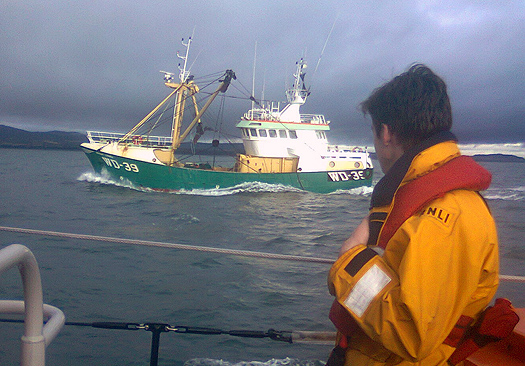
Wicklow lifeboat tows the yacht to safety last night

The lifeboat crew under the command of Coxswain Ciaran Doyle located the stricken yacht about one mile east of the North Arklow buoy and was alongside less than 30 minutes after launching. Once a towline had been rigged by the lifeboat crew the casualty was taken under tow to Wicklow harbour. The yacht was secured alongside the south quay at 7pm and the two sailors were landed safely ashore. This was the second incident the volunteer crew responded to over the weekend.


Published in RNLI Lifeboats

Dublin Bay

Dublin Bay on the east coast of Ireland stretches over seven kilometres, from Howth Head on its northern tip to Dalkey Island in the south. It's a place most Dubliners simply take for granted, and one of the capital's least visited places. But there's more going on out there than you'd imagine.

The biggest boating centre is at Dun Laoghaire Harbour on the Bay's south shore that is home to over 1,500 pleasure craft, four waterfront yacht clubs and Ireland's largest marina.

The bay is rather shallow with many sandbanks and rocky outcrops, and was notorious in the past for shipwrecks, especially when the wind was from the east. Until modern times, many ships and their passengers were lost along the treacherous coastline from Howth to Dun Laoghaire, less than a kilometre from shore.

The Bay is a C-shaped inlet of the Irish Sea and is about 10 kilometres wide along its north-south base, and 7 km in length to its apex at the centre of the city of Dublin; stretching from Howth Head in the north to Dalkey Point in the south. North Bull Island is situated in the northwest part of the bay, where one of two major inshore sandbanks lie, and features a 5 km long sandy beach, Dollymount Strand, fronting an internationally recognised wildfowl reserve. Many of the rivers of Dublin reach the Irish Sea at Dublin Bay: the River Liffey, with the River Dodder flow received less than 1 km inland, River Tolka, and various smaller rivers and streams.

Dublin Bay FAQs

There are approximately ten beaches and bathing spots around Dublin Bay: Dollymount Strand; Forty Foot Bathing Place; Half Moon bathing spot; Merrion Strand; Bull Wall; Sandycove Beach; Sandymount Strand; Seapoint; Shelley Banks; Sutton, Burrow Beach

There are slipways on the north side of Dublin Bay at Clontarf, Sutton and on the southside at Dun Laoghaire Harbour, and in Dalkey at Coliemore and Bulloch Harbours.

Dublin Bay is administered by a number of Government Departments, three local authorities and several statutory agencies. Dublin Port Company is in charge of navigation on the Bay.

Dublin Bay is approximately 70 sq kilometres or 7,000 hectares. The Bay is about 10 kilometres wide along its north-south base, and seven km in length east-west to its peak at the centre of the city of Dublin; stretching from Howth Head in the north to Dalkey Point in the south.

Dun Laoghaire Harbour on the southside of the Bay has an East and West Pier, each one kilometre long; this is one of the largest human-made harbours in the world. There also piers or walls at the entrance to the River Liffey at Dublin city known as the Great North and South Walls. Other harbours on the Bay include Bulloch Harbour and Coliemore Harbours both at Dalkey.

There are two marinas on Dublin Bay. Ireland's largest marina with over 800 berths is on the southern shore at Dun Laoghaire Harbour. The other is at Poolbeg Yacht and Boat Club on the River Liffey close to Dublin City.

Car and passenger Ferries operate from Dublin Port to the UK, Isle of Man and France. A passenger ferry operates from Dun Laoghaire Harbour to Howth as well as providing tourist voyages around the bay.

Dublin Bay has two Islands. Bull Island at Clontarf and Dalkey Island on the southern shore of the Bay.

The River Liffey flows through Dublin city and into the Bay. Its tributaries include the River Dodder, the River Poddle and the River Camac.

Dollymount, Burrow and Seapoint beaches

Approximately 1,500 boats from small dinghies to motorboats to ocean-going yachts. The vast majority, over 1,000, are moored at Dun Laoghaire Harbour which is Ireland's boating capital.

In 1981, UNESCO recognised the importance of Dublin Bay by designating North Bull Island as a Biosphere because of its rare and internationally important habitats and species of wildlife. To support sustainable development, UNESCO’s concept of a Biosphere has evolved to include not just areas of ecological value but also the areas around them and the communities that live and work within these areas. There have since been additional international and national designations, covering much of Dublin Bay, to ensure the protection of its water quality and biodiversity. To fulfil these broader management aims for the ecosystem, the Biosphere was expanded in 2015. The Biosphere now covers Dublin Bay, reflecting its significant environmental, economic, cultural and tourism importance, and extends to over 300km² to include the bay, the shore and nearby residential areas.

On the Southside at Dun Laoghaire, there is the National Yacht Club, Royal St. George Yacht Club, Royal Irish Yacht Club and Dun Laoghaire Motor Yacht Club as well as Dublin Bay Sailing Club. In the city centre, there is Poolbeg Yacht and Boat Club. On the Northside of Dublin, there is Clontarf Yacht and Boat Club and Sutton Dinghy Club. While not on Dublin Bay, Howth Yacht Club is the major north Dublin Sailing centre.

© Afloat 2020