Menu

Ireland's sailing, boating & maritime magazine

Dublin Bay Boating News and Information

Displaying items by tag: floating wind farm

Stoura, an old Shetland word for windy and for wide open space, has been selected as the new name for the ESB’s 500MW floating wind farm off the coast of the Scottish islands.

Stoura Wind Farm replaces the old name of Sealtainn after a contest held about all Shetland primary school children.

Entries were judged by four locals with confirmation from an expert that the winning name is in Shetland dialect.

“The overall winner, who attends Bells Brae Primary School in Lerwick, has generously decided to share the £1,250 prize fund with their classmates and a local charity,” the ESB said, and it had “matched this generosity” with a donation of its own..

The name is used for several local landmarks, including Stoura Stack, a sea stack in the Out Skerries islands, the closest part of Shetland to the proposed wind farm.

The Shetland dialect has both Nordic and Scottish roots and is a valued and essential element of Shetland's distinctive heritage and culture – with Tammie Norrie, for instance, the name for a puffin.

Spelling and interpretation of words can vary across the islands, and more details are here

Published in Power From the Sea
Tagged under

An Irish renewable energy company has partnered with French energy major Total to develop one of the world’s largest floating wind projects off the Welsh coast.

Marine Renewables Industry Association (MRIA) chairman Peter Coyle has described the Simply Blue Energy and Total partnership as a “remarkable achievement”.

As The Sunday Times reports, Simply Blue Energy, founded by Sam Roch-Perks, has secured Total’s support for a joint venture 96MW floating wind farm in 70 metres of water about 45km off Pembroke in the Celtic Sea.

The project is a “stepping stone” to a more ambitious operation and could be operating within the next five years if given approval by the British Crown Estate.

Floating platforms are regarded as the future for offshore wind, and a recent Crown Estate Scotland study predicted a potential yield of some 34 billion pounds sterling for the British economy by 2050.

Simply Blue Energy Celtic Sea Map
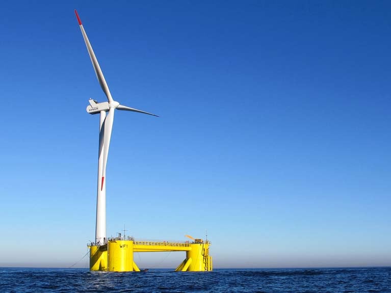
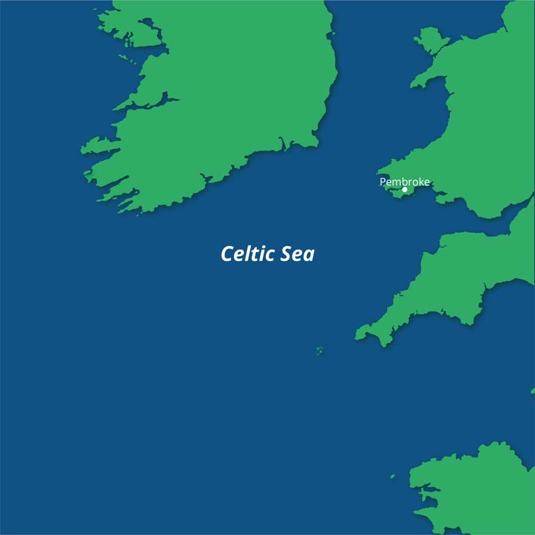
The Simply Blue Energy Celtic Sea 96MW floating wind farm is in 70 metres of water about 45km off Pembroke in the Celtic Sea

The world’s first commercial floating wind farm, the 30 MW Hywind Scotland project developed by Norwegian energy company Equinor (formerly Statoil) and Masdar off Aberdeen, was commissioned in 2017.

The Total/Simply Blue Energy project has been named Erebus – both the Greek mythological son of Chaos and name of one of Sir John Franklin’s ill-fated North-West passage ships which had been built in Pembroke dockyard in Wales and disappeared in 1848.

The project involves mounting 8 to 12MW turbines on semi-submersible “WindFloat” platforms supplied by Principle Power, with generated energy feeding into an established grid connection at Pembroke.

Simply Blue Energy was founded in 2011 by Roch-Perks, an engineer and property developer. It employs 12 people in energy and aquaculture projects and has offices in Cornwall, Pembroke, Edinburgh and Waterford.

MRIA chairman Peter Coyle said the Simply Blue Energy Erebus project is a “very significant development in the Irish business world for two reasons”.

“It is a remarkable achievement for a small Irish start-up to win the support and trust of Total, one of the world’s largest oil companies, and to do so for a project which will be the largest floating wind – a novel and demanding technology – project in the world to date,” Mr Coyle said.

“The success of Erebus in Welsh waters is vital to Irish offshore renewable energy ambitions as it will prove the technology and open up the scope for our enormous wind resource in deep waters to be harnessed to generate electricity for both local and export use,” he added.

“It is hugely significant that an accomplished Irish business person like Sam Roch Perks, CEO of Simply Blue Energy, who has had a stellar business track record in Asia and Sweden, should opt to focus on the new world of offshore energy rather than devote his resources to more fashionable and safe opportunities in areas such as software development,” Mr Coyle said.

“Our world-beating wind and wave resource for electricity generation is perhaps the biggest opportunity for income and job creation facing Ireland over the coming decades and the early success of Simply Blue Energy in this pioneering partnership with one of Europe’s largest companies will be a key milestone and a remarkable achievement”.

For more on The Sunday Times report, read here

Published in Power From the Sea

Dublin Bay

Dublin Bay on the east coast of Ireland stretches over seven kilometres, from Howth Head on its northern tip to Dalkey Island in the south. It's a place most Dubliners simply take for granted, and one of the capital's least visited places. But there's more going on out there than you'd imagine.

The biggest boating centre is at Dun Laoghaire Harbour on the Bay's south shore that is home to over 1,500 pleasure craft, four waterfront yacht clubs and Ireland's largest marina.

The bay is rather shallow with many sandbanks and rocky outcrops, and was notorious in the past for shipwrecks, especially when the wind was from the east. Until modern times, many ships and their passengers were lost along the treacherous coastline from Howth to Dun Laoghaire, less than a kilometre from shore.

The Bay is a C-shaped inlet of the Irish Sea and is about 10 kilometres wide along its north-south base, and 7 km in length to its apex at the centre of the city of Dublin; stretching from Howth Head in the north to Dalkey Point in the south. North Bull Island is situated in the northwest part of the bay, where one of two major inshore sandbanks lie, and features a 5 km long sandy beach, Dollymount Strand, fronting an internationally recognised wildfowl reserve. Many of the rivers of Dublin reach the Irish Sea at Dublin Bay: the River Liffey, with the River Dodder flow received less than 1 km inland, River Tolka, and various smaller rivers and streams.

Dublin Bay FAQs

There are approximately ten beaches and bathing spots around Dublin Bay: Dollymount Strand; Forty Foot Bathing Place; Half Moon bathing spot; Merrion Strand; Bull Wall; Sandycove Beach; Sandymount Strand; Seapoint; Shelley Banks; Sutton, Burrow Beach

There are slipways on the north side of Dublin Bay at Clontarf, Sutton and on the southside at Dun Laoghaire Harbour, and in Dalkey at Coliemore and Bulloch Harbours.

Dublin Bay is administered by a number of Government Departments, three local authorities and several statutory agencies. Dublin Port Company is in charge of navigation on the Bay.

Dublin Bay is approximately 70 sq kilometres or 7,000 hectares. The Bay is about 10 kilometres wide along its north-south base, and seven km in length east-west to its peak at the centre of the city of Dublin; stretching from Howth Head in the north to Dalkey Point in the south.

Dun Laoghaire Harbour on the southside of the Bay has an East and West Pier, each one kilometre long; this is one of the largest human-made harbours in the world. There also piers or walls at the entrance to the River Liffey at Dublin city known as the Great North and South Walls. Other harbours on the Bay include Bulloch Harbour and Coliemore Harbours both at Dalkey.

There are two marinas on Dublin Bay. Ireland's largest marina with over 800 berths is on the southern shore at Dun Laoghaire Harbour. The other is at Poolbeg Yacht and Boat Club on the River Liffey close to Dublin City.

Car and passenger Ferries operate from Dublin Port to the UK, Isle of Man and France. A passenger ferry operates from Dun Laoghaire Harbour to Howth as well as providing tourist voyages around the bay.

Dublin Bay has two Islands. Bull Island at Clontarf and Dalkey Island on the southern shore of the Bay.

The River Liffey flows through Dublin city and into the Bay. Its tributaries include the River Dodder, the River Poddle and the River Camac.

Dollymount, Burrow and Seapoint beaches

Approximately 1,500 boats from small dinghies to motorboats to ocean-going yachts. The vast majority, over 1,000, are moored at Dun Laoghaire Harbour which is Ireland's boating capital.

In 1981, UNESCO recognised the importance of Dublin Bay by designating North Bull Island as a Biosphere because of its rare and internationally important habitats and species of wildlife. To support sustainable development, UNESCO’s concept of a Biosphere has evolved to include not just areas of ecological value but also the areas around them and the communities that live and work within these areas. There have since been additional international and national designations, covering much of Dublin Bay, to ensure the protection of its water quality and biodiversity. To fulfil these broader management aims for the ecosystem, the Biosphere was expanded in 2015. The Biosphere now covers Dublin Bay, reflecting its significant environmental, economic, cultural and tourism importance, and extends to over 300km² to include the bay, the shore and nearby residential areas.

On the Southside at Dun Laoghaire, there is the National Yacht Club, Royal St. George Yacht Club, Royal Irish Yacht Club and Dun Laoghaire Motor Yacht Club as well as Dublin Bay Sailing Club. In the city centre, there is Poolbeg Yacht and Boat Club. On the Northside of Dublin, there is Clontarf Yacht and Boat Club and Sutton Dinghy Club. While not on Dublin Bay, Howth Yacht Club is the major north Dublin Sailing centre.

© Afloat 2020