Menu

Ireland's sailing, boating & maritime magazine

Dublin Bay Boating News and Information

Displaying items by tag: lowtown

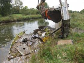
The salvage and disposal of a number of sunk and abandoned vessels from the Barrow Line of the Grand Canal at Lowtown took place on 12-13 October 2016 by Waterways Ireland.

As part of the canals clean up a number of sunken and abandoned, non permitted, vessels were targeted for removal and disposal from the canals. Every effort was made to trace owners of the vessels via the permit database, Shannon Registration number or local knowledge. No owners or interested parties were found.

Upon inspection of all vessels by the Assistant Inspector of Navigation, it was determined that none of the vessels were salvageable and were beyond economic repair. Consequently it was decided to remove and dispose of the wrecks. A company was contracted to undertake the work.

The first vessel, a steel hulk has been sunk on the Eastern bank of the Barrow Line for approximately 5 years. Accumulated debris and rubbish hindered the pump out but eventually the vessel was floated. The vessel was recovered onto the canal bank after 7 hours of work. As initial cuts with cutting equipment were made, Waterways Ireland received a request from Heritage Boat Association to pause the removal of the vessel as it potentially had heritage value. No further cutting was done and the hulk has been left on the canal bank, overturned to prevent further ingress of water, while the HBA's interest is followed up.

Removal of the other vessels went ahead as planned. Most vessels broke up as they were being towed to the Western bank for disposal. A diver in the water recovered all floating debris and heavy materials were recovered with the assistance of a digger bucket.

One vessel was pumped out and returned to its owner who was identified after a number of phone calls on 13th October.

Vessel removal was completed on 13th October with contractor returning on site on 14th October to "dress" the bank and remove any remaining debris.

Waterways Ireland requests owners of boats on the Grand Canal, Royal Canal and Barrow Navigation to ensure they have a valid permit and that the Inspector of Navigation has been provided with up to date contact details.

Published in Inland Waterways

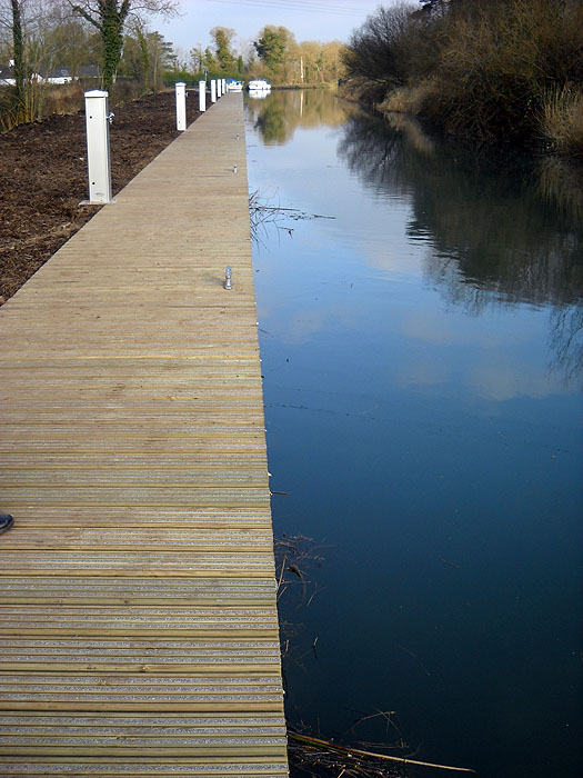
#lowtown – Waterways Ireland's work to redevelop the moorings and other amenities on the Grand Canal and Old Barrow Line at Lowtown, Co Kildare is nearing completion and will be opened shortly.

Waterways Ireland had already provided a new amenity block including toilets and showers at the area and has gone on to add extensive facilities for both touring boats and boats wishing to take an Extended Mooring. 350 meters of fixed timber mooring have been installed all of which have water & lighting and a proportion also have electricity.

On the Old Barrow Line and Grand Canal Main Line 100m and 80m respectively of fixed timber moorings, have been constructed with service bollards providing lighting and water.

Additionally on the Grand Canal Main Line 170m of fixed timber moorings have been constructed on the with service bollards providing electricity, lighting and water. The electricity provision is operated by smart card available from the Waterways Ireland webshop shopwaterwaysireland.org . Waterways Ireland has also constructed a dedicated parking area and bin area for boats using the long term facility.

A proportion of the moorings on the Grand Canal Main Line are being set aside for Extended Mooring Permit holders. The remainder will be for visiting boats displaying a valid Combined Mooring and Passage Permit (CMP) and following the 5 day mooring rule laid down in the Bye-laws. The balance between touring and extended moorings will be determined by the level of approved applications for Extended Mooring Permits.

The works, designed by Waterways Ireland and undertaken by LM Keating, Co Clare also included the construction of a canal overflow on the Grand Canal at Derrymullen in order to assist with the management of water levels.

mooringbarrowline

New Waterways Ireland moorings on the Barrow line ready for the 2013 boating season

Application for Extended Moorings at Lowtown opened on the 4th March 2013, cost €152 for 12 months and are allocated on a first come, first served basis. Applicants need also hold a CMP (€126) and can apply using the same application form. The form can be downloaded from www.waterwaysireland.org or send out by post from Waterways Ireland Tullamore (Tel 057 9352300).

Boat owners with boats on the Grand Canal, Barrow Navigation and Royal Canal should be aware that from the 19th March the mooring bye-laws will be enforced.

More information is available from Shane Anderson, Assistant Inspector of Navigation: Tel no +353 (0)87 286 5726, Email [email protected] .

Published in Inland Waterways
Tagged under

Dublin Bay

Dublin Bay on the east coast of Ireland stretches over seven kilometres, from Howth Head on its northern tip to Dalkey Island in the south. It's a place most Dubliners simply take for granted, and one of the capital's least visited places. But there's more going on out there than you'd imagine.

The biggest boating centre is at Dun Laoghaire Harbour on the Bay's south shore that is home to over 1,500 pleasure craft, four waterfront yacht clubs and Ireland's largest marina.

The bay is rather shallow with many sandbanks and rocky outcrops, and was notorious in the past for shipwrecks, especially when the wind was from the east. Until modern times, many ships and their passengers were lost along the treacherous coastline from Howth to Dun Laoghaire, less than a kilometre from shore.

The Bay is a C-shaped inlet of the Irish Sea and is about 10 kilometres wide along its north-south base, and 7 km in length to its apex at the centre of the city of Dublin; stretching from Howth Head in the north to Dalkey Point in the south. North Bull Island is situated in the northwest part of the bay, where one of two major inshore sandbanks lie, and features a 5 km long sandy beach, Dollymount Strand, fronting an internationally recognised wildfowl reserve. Many of the rivers of Dublin reach the Irish Sea at Dublin Bay: the River Liffey, with the River Dodder flow received less than 1 km inland, River Tolka, and various smaller rivers and streams.

Dublin Bay FAQs

There are approximately ten beaches and bathing spots around Dublin Bay: Dollymount Strand; Forty Foot Bathing Place; Half Moon bathing spot; Merrion Strand; Bull Wall; Sandycove Beach; Sandymount Strand; Seapoint; Shelley Banks; Sutton, Burrow Beach

There are slipways on the north side of Dublin Bay at Clontarf, Sutton and on the southside at Dun Laoghaire Harbour, and in Dalkey at Coliemore and Bulloch Harbours.

Dublin Bay is administered by a number of Government Departments, three local authorities and several statutory agencies. Dublin Port Company is in charge of navigation on the Bay.

Dublin Bay is approximately 70 sq kilometres or 7,000 hectares. The Bay is about 10 kilometres wide along its north-south base, and seven km in length east-west to its peak at the centre of the city of Dublin; stretching from Howth Head in the north to Dalkey Point in the south.

Dun Laoghaire Harbour on the southside of the Bay has an East and West Pier, each one kilometre long; this is one of the largest human-made harbours in the world. There also piers or walls at the entrance to the River Liffey at Dublin city known as the Great North and South Walls. Other harbours on the Bay include Bulloch Harbour and Coliemore Harbours both at Dalkey.

There are two marinas on Dublin Bay. Ireland's largest marina with over 800 berths is on the southern shore at Dun Laoghaire Harbour. The other is at Poolbeg Yacht and Boat Club on the River Liffey close to Dublin City.

Car and passenger Ferries operate from Dublin Port to the UK, Isle of Man and France. A passenger ferry operates from Dun Laoghaire Harbour to Howth as well as providing tourist voyages around the bay.

Dublin Bay has two Islands. Bull Island at Clontarf and Dalkey Island on the southern shore of the Bay.

The River Liffey flows through Dublin city and into the Bay. Its tributaries include the River Dodder, the River Poddle and the River Camac.

Dollymount, Burrow and Seapoint beaches

Approximately 1,500 boats from small dinghies to motorboats to ocean-going yachts. The vast majority, over 1,000, are moored at Dun Laoghaire Harbour which is Ireland's boating capital.

In 1981, UNESCO recognised the importance of Dublin Bay by designating North Bull Island as a Biosphere because of its rare and internationally important habitats and species of wildlife. To support sustainable development, UNESCO’s concept of a Biosphere has evolved to include not just areas of ecological value but also the areas around them and the communities that live and work within these areas. There have since been additional international and national designations, covering much of Dublin Bay, to ensure the protection of its water quality and biodiversity. To fulfil these broader management aims for the ecosystem, the Biosphere was expanded in 2015. The Biosphere now covers Dublin Bay, reflecting its significant environmental, economic, cultural and tourism importance, and extends to over 300km² to include the bay, the shore and nearby residential areas.

On the Southside at Dun Laoghaire, there is the National Yacht Club, Royal St. George Yacht Club, Royal Irish Yacht Club and Dun Laoghaire Motor Yacht Club as well as Dublin Bay Sailing Club. In the city centre, there is Poolbeg Yacht and Boat Club. On the Northside of Dublin, there is Clontarf Yacht and Boat Club and Sutton Dinghy Club. While not on Dublin Bay, Howth Yacht Club is the major north Dublin Sailing centre.

© Afloat 2020