Displaying items by tag: pollution
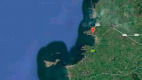
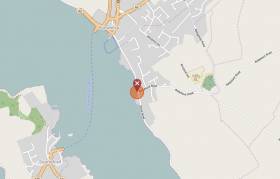
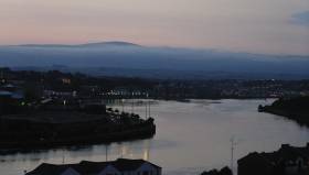
A training exercise testing the response capabilities of Shannon Foynes Port Company, local authorities and other organisations who operate in the vicinity of the Shannon Estuary will take place at Spanish Point, County Clare, on Wednesday and Thursday of next week (26-27 April).
The simulated event, which is being hosted by Clare County Council on behalf of the Shannon Estuary Anti-Pollution Team (SEA-PT), will centre on a major spillage of crude oil having occurred from an oil exploration platform located approximately 220km off the south west coast of Ireland and oil coming ashore at Spanish Point.
Other parameters for the exercise will include notification that the source of the pollution has been brought under control and that there have been no casualties on the oil exploration platform.
There will be a practical element on site at Spanish Point involving operation and demonstration of equipment while a technical briefing will be carried out on equipment on site for officials. The second day of the event will consist of the management of a simulated large scale event for senior management of Local Authorities, SEA-PT members and the Coastguard in Clare County Council’s headquarters at Áras Contae an Chláir, Ennis, which will act as the Incident Command Centre.
“Spill simulations are an excellent way to exercise and train personnel in their emergency roles and to test contingency plans and procedures,” explained John Leahy, Senior Engineer, Clare County Council.
“Valuable lessons can be learned from such exercises, which include a variety of participants, such as oil spill management teams, field responders and regulators and community members. Participants will work together in conducting a simulated response to this hypothetical incident in order to demonstrate proficiency and validity of the oil pollution response plan which is in place for Clare,” he said.
Clare County Council has advised that the training event will not be open to the public while the northern end of the public carpark will be closed off to the public on 25th and 26th April. Public access to Spanish Point beach will be maintained throughout the exercise.
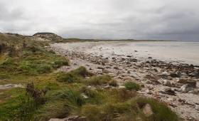
Crude Oil ‘Tar Balls’ Mar Achill Beach
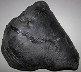
#CoastalNotes - Achill Island has been blemished by ‘tar balls’ that washed up on its Blue-Flagged Keel Beach during the week, as The Irish Times reports.
Appearing as black stones from a distance, the blobs of crude oil are soft and extremely sticky to the touch.
But despite being the result of oil leaks at sea, such tar balls are considered relatively harmless, according to the Irish Coast Guard.
The news comes less than a month after Fingal County Council warned of palm oil ‘fatbergs’ washed up on a Skerries beach.
Similar fatty deposits were found on beaches in Mayo last November.
Hazardous Waste Polluting Coast At Former Bray Landfill Site
#Pollution - An old landfill site in Bray continues to leak hazardous waste into the Irish Sea, according to TheJournal.ie.
Broken asbestos tiles and potassium deposits are among the pollutants leaching into the water due to coastal erosion at the former landfill — an issue highlighted recently by Ireland South MEP Liadh Ní Riada, who also noted similar sites in Waterford, Cork and elsewhere.
Afloat.ie previously reported on the disused rubbish tip north of the Co Wicklow seaside town two years ago, citing Coastwatch’s claim that the problem has existed for more than two decades as 200m of the site has been exposed to weathering and wave action.
Commenting on the issue in the Dáil, Environment Minister Denis Naughten said it was a matter for the local authorities concerned, and that an Environmental Risk Assessment was advised over a year ago.
TheJournal.ie has more on the story HERE.
Fingal Council Urges Vigilance Over Palm Oil ‘Fatbergs’
#CoastalNotes - Fingal County Council has issued a warning for people to be vigilant for palm oil ‘fatbergs’ along the North Dublin coast as they can be particularly dangerous to dogs.
A number of fatty balls were found on Sunday (12 February) at Hoare’s Rock in Skerries, Co Dublin, and results from laboratory tests have showed that the substance was palm oil.
It’s thought that the oil was part of a consignment which came off a ship in the English Channel about 18 months ago and was washed ashore by the weekend storm.
The congealed substance has been turning up sporadically on beaches and coasts in England but this is the first time it has been recorded in Fingal.
Similar fatty deposits washed up on Mayo beaches last November, as previously reported on Afloat.ie.
“We believe the discovery of this material in Skerries on Sunday is an isolated incident as we have not had any other sightings along the Fingal coastline,” said a council spokesperson.
“The material is a solid white substance which is known as a ‘palm oil fatberg’ and they can range in size from being as  small as a golf ball to as big as a boulder.
“We are asking the public to be vigilant as this substance can be harmful to dogs.”
Sunken Boat Sparks Strangford Lough Fuel Spill Fears
#StrangfordLough - Leaking fuel from a submerged boat in Strangford Lough has promoted environmental concerns, as BelfastLive reports.
The three-masted vessel, which has been moored in Portaferry Harbour for some time, crashed into the quay, and sank on Friday (27 January).
And there are now fears of a major pollution incident after some of the 1,000 litres of diesel still on board began leaking into the lough.
The nearby Exploris Aquarium has among others taken the precaution of closing its intake from Strangford Lough, which is a Special Protection Area for marine wildlife.
BelfastLive has more on the story HERE.
Raw Sewage Discharged In Over 40 Spots Nationwide Says EPA
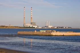
#Pollution - Cork Harbour, Ringsend in Dublin and more than 40 other Irish riverside or coastal towns and cities in still fail to meet EU sewage standards, according to a damning new EPA report.
RTÉ News has details of the environmental agency’s 2015 Urban Waste Water Treatment Report, which identifies 43 urban areas — 29 of them classed as large towns or cities – that continue to release raw sewage into the sea and rivers across Ireland.
A number of these locations have seen their timetable for tackling such discharges slip by almost two years due to lack of sufficient capital investment, which the EPA decries as “unacceptable”.
In locations such as Youghal and Merrion Strand, the release of untreated waste has been linked to a significant lowering of bathing water quality.
The news is little different from almost three years ago, when the EPA identified the likes of Killybegs in Co Donegal and Cork Harbour as black spots for untreated wastewater.
More recently, Housing Minister Simon Coveney promised that the problem of discharges from a number of communities around Cork Harbour would be solved within the next 18 months, as previously reported on Afloat.ie.
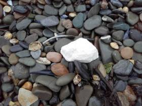
Warning Over ‘Fat Balls’ On Mayo Beaches
#CoastalNotes - Dog walkers have been warned to keep their pets away from smelly, fatty globules that have washed up on the North Mayo coast in recent weeks, as The Irish Times reports.
One woman on the Mullet Peninsula says her dog became ill after eating part of one of the ball-like fatty deposits, which could be the waste products of materials used to clean up oil spills at sea — or possibly congealed palm oil used for cooking and released legally by ocean-going vessels.
The Irish Times has much more on the story HERE.
Cork Cement Company Prosecuted Over River Pollution

#Pollution - Inland Fisheries Ireland (IFI) has prosecuted cement company Keohane Readymix Limited over a discharge into the Argideen River at Fourcuil in Clonakilty, Co Cork on 9 March last.
At a sitting of Clonakilty District Court on Tuesday 18 October, Keohane Readymix Limited pleaded guilty to a breach of Sections 171(1) and 173(1)(c) of the Fisheries (Consolidation) Act 1959. The company were ordered to pay over €10,000 by Judge James McNulty.
The court heard how a breach in a settlement pond at a sand and gravel washing site on Wednesday 9 March caused a significant overflow of wastewater carrying suspended solids into the Argideen River. IFI officers investigated the incident and identified the source of the pollution.
Judge McNulty imposed a fine of €2,500 in respect of the first count to Keohane Readymix and awarded costs and legal expenses of €2,598 to IFI.
In relation to the charge under Section 173(1)(c), the defendant agreed to Judge Mc Nulty’s suggestion of a €5,000 contribution to the Court Charity Fund.
Sean Long, director of the South West River Basin District at IFI, said: “We would urge landowners and businesses to remain vigilant and to employ robust management systems to prevent avoidable incidents which can have a serious impact on our wild fish and their natural habitat.
“Inland Fisheries Ireland is working to protect, conserve and develop our natural fisheries resource which is of significant recreational and economic value to communities in Cork and across the country.”
Inland Fisheries Ireland has a confidential hotline number to enable members of the public to report incidents at 1890 34 74 24 or 1890 FISH 24. This phone line is designed to encourage the reporting of incidents of illegal fishing, water pollution and invasive species.
Cracked Pipe Led To Fish Kill On Co Down River
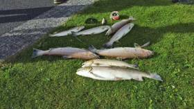
#FishKill - The fish kill on the Annsborough River in Co Down last weekend was caused by a chemical leak from a cracked pipe, accoridng to BBC News.
And NI Water has offered to restock the salmon and sea trout stream, one popular with local angling enthusiasts, days after the incident at its water treatment plant in the area.
As previously reported on Afloat.ie, some 1,600 fish were killed when the river was polluted by what’s since been confirmed as a polyelectrolyte used in processing water treatment byproducts.
"The severity of this incident is very unusual for our company. We truly regret the outcome and the number of fish that have been killed,” said NI Water in a statement.
BBC News has more on the story HERE.
NI Anglers Concerned By Rise In Pollution & Poaching
#Angling - Pollution and poaching are a growing concern for anglers in the Carlingford and Lough Foyle areas, as Derek Evans reports in his latest Angling Notes for The Irish Times.
New figures from the Loughs Agency reveal a significant raise in pollution, the worst incident of which occurred this past August when hundreds of salmon fry were lost in a fish kill on the River Faughan, according to the Derry Journal.
In addition, the Loughs Agency report informed NI Environment Minister Michelle McIlveen of almost double the number of fishing gear seizures this year compared to 2015, as well as a sharp rise in court actions.
The Irish Times has more on the story HERE.


