Displaying items by tag: recreational craft
Minister Cites Marine Casualties Involving Recreational Craft in Launch of New Code of Practice
Minister for Transport, Tourism and Sport Shane Ross TD, says a significant number of Irish Coast Guard call-outs in recent years have been to assist recreational craft.
The Minister's comments were made as a new Code of Practice was launched for the Safe Operation of Recreational Craft that draws on stats over ten years to 2015.
Reports of the Marine Casualty Investigation Board have also indicated that many accidents and deaths in this sector could have been avoided. The key is to think and act safely, the Minister says.
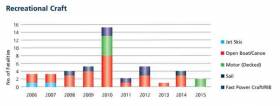
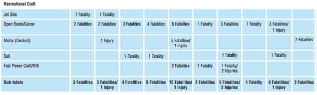
The following extracts from the 2015 Annual Report of the Marine Casualty Investigation Board provide information regarding marine casualties involving recreational craft in the period 2006-2015. The table and chart below give a breakdown of the fatalities by type of craft during the 10 year period up to and including 2015.
Fatalities associated with open boats and canoes have occurred on a regular basis during this period.
 Source: MCIB
New Code of Practice for the Safe Operation of Recreational Craft
Minister for Transport, Tourism and Sport Shane Ross TD, has today launched a new Code of Practice for the Safe Operation of Recreational Craft.
The Code of Practice is a valuable source of information, advice and best practice operational guidance for owners, masters, operators and users of a range of pleasure and recreational craft operating in Irish coastal and inland waters. The new Code of Practice was developed following a review of a 2008 edition within the Irish Maritime Administration and two consultations with key stakeholders.
The Code of Practice is divided into two Parts followed by a series of Appendices.
Part A (Chapter 1) outlines the legislative requirements that apply to all recreational craft or specific types or size of craft. Owners and operators must comply with the requirements appropriate to their craft.
Part B (Chapters 2 to 11) contains recommended guidelines and best practice for the safe operation of a range of recreational craft including sail and motor boats, sailing dinghies, jet skis and high speed power boats, stand-up paddle boards, canoes, kayaks, rowing boats and charter boats. Chapters 10 and 11 provide information on safety operations and emergency procedures, while a series of 11 Appendices cover such topics as radiocommunications, collision prevention, weather and sea states, lifejacket use, passage planning, buoyage and anchoring.
Similar to the Maritime Safety Strategy 2015-2019, which was published in 2015, the message that underlines the Code of Practice is the importance of personal responsibility for all those who take to the water.
Minister Ross encourages all recreational craft users to familiarise themselves with the Code of Practice and to heed the safety advice and recommendations in the Code.
“By making time for maritime safety and taking simple measures such as wearing a lifejacket, each person can contribute to saving lives, starting with their own.”
The Code of Practice for the Safe Operation of Recreational Craft is available to download below.
Marine Notice on Exemptions from EU Regulations for Recreational Water Craft

#NEWS UPDATE - A recent Marine Notice from the Department of Transport, Tourism and Sport (DTTAS) advises consumers, retailers and manufacturers on the types of craft to which the EU recreation water craft regulations do not apply.
In general recreational craft and related products must meet the essential safety, health, environmental protection and consumer protection requirements of the Recreational Craft Directive as set out in the Recreational Craft Regulations.
However, these regulations do not apply to craft intended solely for racing; canoes and kayaks; gondolas and pedalos; surfboards; historical water craft and replicas; experimental craft and ones built for own use; commercial craft; and a number of others.
These exceptions are however still subject to the EU's General Product Safety Directive.
Complete details are included in Marine Notice No 56 of 2011, a PDF of which is available to read and download HERE.
- Marine Notice
- water craft
- regulations
- EU
- Department of Transport, Tourism and Sport
- DTTAS
- consumers
- retailers
- manufacturers
- recreational craft
- Safety
- Health
- environmental protection
- Recreational Craft Directive
- Recreational Craft Regulations
- racing
- Canoes
- Kayaks
- gondolas
- pedalos
- surfboards
- historical
- replica


