Menu

Ireland's sailing, boating & maritime magazine

Dublin Bay Boating News and Information

Displaying items by tag: Toxic

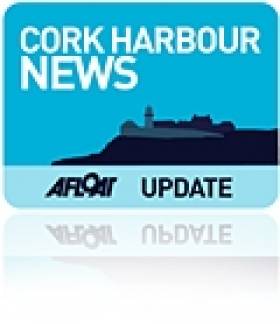
#CorkHarbour - Cork County Council is investigating reports that defences built around the toxic dump on Haulhbowline Island have been breached in the recent severe weather.

According to the Irish Examiner, two Cobh-based councillors reported seeing breaches in the embankments around the dump, which contains an estimated half a million tonnes of waste - including toxic heavy metals and various cancer causing materials such as Chromium 6.

It's now feared that the recent high tides have carried toxic waste out of the site and contaminated the waters of Cork Harbour.

The council has confirmed that tests are being carried out at and around the site, next to the former Irish Steel/Ispat plant.

A full clean-up operation of the toxic dump is expected to begin later this year, though the contract for the job has not yet been awarded, pending the decision of the Environmental Protection Agency on a waste licence application and a nod from An Bord Pleanála for redevelopment of the site.

Published in Cork Harbour
Sean Kelly MEP has welcomed today's impending confirmation that the government will allocate €40 million to clean-up the Haulbowline toxic dump in Cork Harbour over the next two years.

"This is going to come as an enormous relief to the people of Cobh who have quite rightly feared for the health of their community for over ten years with unchecked emissions of a carcinogenic toxin, Chromium VI, coming from an unlicenced landfill," the Ireland South MEP said in Brussels today.

"While a baseline health study has never been carried out, the National Cancer Registry of Ireland proves that the rate of cancer in Cobh is 37% higher than the national average. Furthermore, we cannot forget the environmental and economic concerns also at the fore of the Haulbowline campaign."

haulbowline

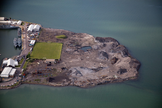
Haulbowline - A €40m clean up has been announced. Photo: Bob Bateman

Mr Kelly, who tirelessly lobbied for action on the site, is now hopeful that this part of his Cork constituency can look towards future economic growth with positivity: "This toxic dump is located in a very scenic part of Ireland and while it is difficult to measure its impact in monetary terms, no one can deny its existence has had a detrimental effect on Cobh's tourism potential.

"Earlier this year, the European Commission directed Irish authorities to take decisive action on the landfill within a three month timeframe under threat of court action. The warning followed a petition of over 5,000 signatures calling for immediate action, I brought before a parliamentary committee in conjunction with Cork Harbour Health pressure group," the MEP continued.

Mr Kelly believes the previous government, the EPA and Cork County Council 'passed the buck on Haulbowline in a disgraceful way'. However, with Cabinet approval of 20m in the 2012 budget and 20m in the 2013 budget due for the restoration of the area, 'it is time to look towards a brighter future for Cobh and Haulbowline Island', according to Mr Kelly.

Published in Cork Harbour

Dublin Bay

Dublin Bay on the east coast of Ireland stretches over seven kilometres, from Howth Head on its northern tip to Dalkey Island in the south. It's a place most Dubliners simply take for granted, and one of the capital's least visited places. But there's more going on out there than you'd imagine.

The biggest boating centre is at Dun Laoghaire Harbour on the Bay's south shore that is home to over 1,500 pleasure craft, four waterfront yacht clubs and Ireland's largest marina.

The bay is rather shallow with many sandbanks and rocky outcrops, and was notorious in the past for shipwrecks, especially when the wind was from the east. Until modern times, many ships and their passengers were lost along the treacherous coastline from Howth to Dun Laoghaire, less than a kilometre from shore.

The Bay is a C-shaped inlet of the Irish Sea and is about 10 kilometres wide along its north-south base, and 7 km in length to its apex at the centre of the city of Dublin; stretching from Howth Head in the north to Dalkey Point in the south. North Bull Island is situated in the northwest part of the bay, where one of two major inshore sandbanks lie, and features a 5 km long sandy beach, Dollymount Strand, fronting an internationally recognised wildfowl reserve. Many of the rivers of Dublin reach the Irish Sea at Dublin Bay: the River Liffey, with the River Dodder flow received less than 1 km inland, River Tolka, and various smaller rivers and streams.

Dublin Bay FAQs

There are approximately ten beaches and bathing spots around Dublin Bay: Dollymount Strand; Forty Foot Bathing Place; Half Moon bathing spot; Merrion Strand; Bull Wall; Sandycove Beach; Sandymount Strand; Seapoint; Shelley Banks; Sutton, Burrow Beach

There are slipways on the north side of Dublin Bay at Clontarf, Sutton and on the southside at Dun Laoghaire Harbour, and in Dalkey at Coliemore and Bulloch Harbours.

Dublin Bay is administered by a number of Government Departments, three local authorities and several statutory agencies. Dublin Port Company is in charge of navigation on the Bay.

Dublin Bay is approximately 70 sq kilometres or 7,000 hectares. The Bay is about 10 kilometres wide along its north-south base, and seven km in length east-west to its peak at the centre of the city of Dublin; stretching from Howth Head in the north to Dalkey Point in the south.

Dun Laoghaire Harbour on the southside of the Bay has an East and West Pier, each one kilometre long; this is one of the largest human-made harbours in the world. There also piers or walls at the entrance to the River Liffey at Dublin city known as the Great North and South Walls. Other harbours on the Bay include Bulloch Harbour and Coliemore Harbours both at Dalkey.

There are two marinas on Dublin Bay. Ireland's largest marina with over 800 berths is on the southern shore at Dun Laoghaire Harbour. The other is at Poolbeg Yacht and Boat Club on the River Liffey close to Dublin City.

Car and passenger Ferries operate from Dublin Port to the UK, Isle of Man and France. A passenger ferry operates from Dun Laoghaire Harbour to Howth as well as providing tourist voyages around the bay.

Dublin Bay has two Islands. Bull Island at Clontarf and Dalkey Island on the southern shore of the Bay.

The River Liffey flows through Dublin city and into the Bay. Its tributaries include the River Dodder, the River Poddle and the River Camac.

Dollymount, Burrow and Seapoint beaches

Approximately 1,500 boats from small dinghies to motorboats to ocean-going yachts. The vast majority, over 1,000, are moored at Dun Laoghaire Harbour which is Ireland's boating capital.

In 1981, UNESCO recognised the importance of Dublin Bay by designating North Bull Island as a Biosphere because of its rare and internationally important habitats and species of wildlife. To support sustainable development, UNESCO’s concept of a Biosphere has evolved to include not just areas of ecological value but also the areas around them and the communities that live and work within these areas. There have since been additional international and national designations, covering much of Dublin Bay, to ensure the protection of its water quality and biodiversity. To fulfil these broader management aims for the ecosystem, the Biosphere was expanded in 2015. The Biosphere now covers Dublin Bay, reflecting its significant environmental, economic, cultural and tourism importance, and extends to over 300km² to include the bay, the shore and nearby residential areas.

On the Southside at Dun Laoghaire, there is the National Yacht Club, Royal St. George Yacht Club, Royal Irish Yacht Club and Dun Laoghaire Motor Yacht Club as well as Dublin Bay Sailing Club. In the city centre, there is Poolbeg Yacht and Boat Club. On the Northside of Dublin, there is Clontarf Yacht and Boat Club and Sutton Dinghy Club. While not on Dublin Bay, Howth Yacht Club is the major north Dublin Sailing centre.

© Afloat 2020