Menu

Ireland's sailing, boating & maritime magazine

Dublin Bay Boating News and Information

Displaying items by tag: unmanned

#Unmanned - School children in South Carolina in the USA are awaiting news on the whereabouts of their unmanned sailboat that made landfall in Ireland's North West this past week.

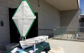
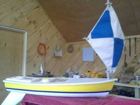
As WCSC Live 5 News reports, the miniature vessel named Cruiser was believed to be on its way to a school in Bangor Erris after reaching the Co Mayo mainland near Achill Island on Wednesday (11 October), some five months after it was launched by students at Harbor View Elementary in Charleston.

If you have any information as to Cruiser’s current whereabouts, you can get in touch with the school HERE.

The news comes six months after the miniature unmanned yacht Lancer was returned to the ocean after sailing from the north east US to Connemara — and bringing together the Connecticut high schooler behind the marine science project with the Galway girl who found the boat near her home.

In July, Lancer was tracked on a return course to Ireland. The boat finally made landfall near Plymouth in Devon last month, but its current whereabouts are unknown.

Published in Marine Science
Tagged under

#Unmanned - Following our previous alert for an unmanned yacht off the Galway coast, the mini-yacht has been found after making landfall.

Kaitlyn Dow's self-built vessel Lancer was launched off the US coast four months ago as part of a high-school marine science project.

The now final-year student at Waterford High School in Connecticut tracked her sailboat by GPS across the Atlantic as it inched towards Galway Bay and Connemara.

It was finally recovered this past Saturday 17 September by eight-year-old Maedhbh Ní Ghionnáin on an island near her home in Lettermore, as The Day reports.

After her aunt received an email from Dow asking for any details of her boat's whereabouts, Maedhbh's family had been keeping a lookout before they found it on a beach virtually on their doorstep.

“In the middle of the day we went walking by the sea, and then we saw this white thing,” said Maedhbh, who also shared the story of her remarkable discovery with Raidió na Gaeltachta.

The news comes a month after another unmanned research sailboat was reported off the Kerry coast after nearly three years in the North Atlantic.

Published in Coastal Notes

#Unmanned - A miniature unmanned sailing boat has been reported off the Kerry coast after nearly three years in the North Atlantic.

The boat, named West, is part of the Educational Passages project by the Middle School of Westbrook in Maine, USA and is one of five boats the Sebago School Alliance sent out in the autumn and winter of 2013-14.

West was launched off Georges Bank along with one other boat by Bro Cote, a lobsterman out of Hyannis, Massachusetts. Several others were launched about the same time off the Mid-East coast of the United States and off the Canary Islands for the marine science project.

“We had hoped the boat would make the complete circle of the Atlantic Ocean. It has and then some,” say the project organsiers about West, which has been spotted 32 nautical miles from the Kerry coastline.

West could arrive in the Kerry area over the next few days or, depending upon weather conditions, may go further northwards towards the Galway coast.

Previously West made landfall in November 2014 when it crashed on rocks in rough seas off Portugal, where it was recovered by local authorities and repaired with the help of local companies and relaunched from Lisbon in June last year.


Four months later, it was recovered entering the Mediterranean, refurbished again and put on a cargo ship to Madeira and relaunched from there on 28 January this year.

The project co-ordinators have asked for assistance to help rescue the boat when it arrives in the coming days

“It would be great if the boat could be recovered at sea or shortly after landing to avoid damage."

Find out more about the Educational Passages project HERE.

Published in Marine Science
An unmanned robotic yacht launched as part of a transatlantic challenge last month has disappeared without trace after going in the wrong direction. It was the first time scientists at Aberystwyth University on the West Coast of Wales had attempted the Microtransat Challenge crossing. More HERE from the BBC.
Published in Offshore

Dublin Bay

Dublin Bay on the east coast of Ireland stretches over seven kilometres, from Howth Head on its northern tip to Dalkey Island in the south. It's a place most Dubliners simply take for granted, and one of the capital's least visited places. But there's more going on out there than you'd imagine.

The biggest boating centre is at Dun Laoghaire Harbour on the Bay's south shore that is home to over 1,500 pleasure craft, four waterfront yacht clubs and Ireland's largest marina.

The bay is rather shallow with many sandbanks and rocky outcrops, and was notorious in the past for shipwrecks, especially when the wind was from the east. Until modern times, many ships and their passengers were lost along the treacherous coastline from Howth to Dun Laoghaire, less than a kilometre from shore.

The Bay is a C-shaped inlet of the Irish Sea and is about 10 kilometres wide along its north-south base, and 7 km in length to its apex at the centre of the city of Dublin; stretching from Howth Head in the north to Dalkey Point in the south. North Bull Island is situated in the northwest part of the bay, where one of two major inshore sandbanks lie, and features a 5 km long sandy beach, Dollymount Strand, fronting an internationally recognised wildfowl reserve. Many of the rivers of Dublin reach the Irish Sea at Dublin Bay: the River Liffey, with the River Dodder flow received less than 1 km inland, River Tolka, and various smaller rivers and streams.

Dublin Bay FAQs

There are approximately ten beaches and bathing spots around Dublin Bay: Dollymount Strand; Forty Foot Bathing Place; Half Moon bathing spot; Merrion Strand; Bull Wall; Sandycove Beach; Sandymount Strand; Seapoint; Shelley Banks; Sutton, Burrow Beach

There are slipways on the north side of Dublin Bay at Clontarf, Sutton and on the southside at Dun Laoghaire Harbour, and in Dalkey at Coliemore and Bulloch Harbours.

Dublin Bay is administered by a number of Government Departments, three local authorities and several statutory agencies. Dublin Port Company is in charge of navigation on the Bay.

Dublin Bay is approximately 70 sq kilometres or 7,000 hectares. The Bay is about 10 kilometres wide along its north-south base, and seven km in length east-west to its peak at the centre of the city of Dublin; stretching from Howth Head in the north to Dalkey Point in the south.

Dun Laoghaire Harbour on the southside of the Bay has an East and West Pier, each one kilometre long; this is one of the largest human-made harbours in the world. There also piers or walls at the entrance to the River Liffey at Dublin city known as the Great North and South Walls. Other harbours on the Bay include Bulloch Harbour and Coliemore Harbours both at Dalkey.

There are two marinas on Dublin Bay. Ireland's largest marina with over 800 berths is on the southern shore at Dun Laoghaire Harbour. The other is at Poolbeg Yacht and Boat Club on the River Liffey close to Dublin City.

Car and passenger Ferries operate from Dublin Port to the UK, Isle of Man and France. A passenger ferry operates from Dun Laoghaire Harbour to Howth as well as providing tourist voyages around the bay.

Dublin Bay has two Islands. Bull Island at Clontarf and Dalkey Island on the southern shore of the Bay.

The River Liffey flows through Dublin city and into the Bay. Its tributaries include the River Dodder, the River Poddle and the River Camac.

Dollymount, Burrow and Seapoint beaches

Approximately 1,500 boats from small dinghies to motorboats to ocean-going yachts. The vast majority, over 1,000, are moored at Dun Laoghaire Harbour which is Ireland's boating capital.

In 1981, UNESCO recognised the importance of Dublin Bay by designating North Bull Island as a Biosphere because of its rare and internationally important habitats and species of wildlife. To support sustainable development, UNESCO’s concept of a Biosphere has evolved to include not just areas of ecological value but also the areas around them and the communities that live and work within these areas. There have since been additional international and national designations, covering much of Dublin Bay, to ensure the protection of its water quality and biodiversity. To fulfil these broader management aims for the ecosystem, the Biosphere was expanded in 2015. The Biosphere now covers Dublin Bay, reflecting its significant environmental, economic, cultural and tourism importance, and extends to over 300km² to include the bay, the shore and nearby residential areas.

On the Southside at Dun Laoghaire, there is the National Yacht Club, Royal St. George Yacht Club, Royal Irish Yacht Club and Dun Laoghaire Motor Yacht Club as well as Dublin Bay Sailing Club. In the city centre, there is Poolbeg Yacht and Boat Club. On the Northside of Dublin, there is Clontarf Yacht and Boat Club and Sutton Dinghy Club. While not on Dublin Bay, Howth Yacht Club is the major north Dublin Sailing centre.

© Afloat 2020