


Displaying items by tag: Atlantic Ocean Research Alliance
Ireland at Forefront of New Cross-National Group Supporting Atlantic Ocean Research and Innovation
The Marine Institute’s director of policy, innovation and research services is leading a new cross-national support group for Atlantic Ocean research and innovation.
Through a large-scale basin effort, representatives of 16 organisations from 12 countries including Ireland have joined forces to establish the Okeano Coordination and Support Action (CSA).
Funded under Horizon Europe to support the All-Atlantic Ocean Research and Innovation Alliance (AAORIA), Okeano “marks a significant milestone in the journey towards sustainable management of the Atlantic Ocean”.
Okeano follows its two successful predecessor CSAs, the Atlantic Ocean Research Alliance and the All-Atlantic Cooperation for Ocean Research and innovation.
The main objective of Okeano is to provide coordination and support to the All-Atlantic Ocean Research and Innovation Alliance, ensuring effective governance, cooperation and communication among signatories, across the Atlantic Ocean, from pole to pole.
Okeano aims to facilitate dialogue and cooperation at local, national, and international levels, to consolidate existing initiatives and to tackle socio-environmental issues in the Atlantic region, such as climate change, biodiversity loss, pollution, ecosystem protection and restoration, and sustainable and inclusive ocean economies.
Signed in 2022, the AAORIA Declaration builds on the foundations of the Galway Statement on Atlantic Ocean Cooperation and the Belém Statement on Atlantic Research and Innovation Cooperation.
Furthermore, its objectives align with the EU's priorities outlined in the European Mission Restore our Ocean and Waters by 2030, the partnership for a climate-neutral sustainable and productive blue economy, the European Green Deal, and international dimension of the EU Atlantic Action Plan.
With AAORIA’s motto being ‘Connecting-Cooperating-Acting’, Okeano will serve to scale and transition the alliance to a long-term, sustainable and highly impactful international partnership, capable of delivering transformative science and innovation, and concrete benefits for Atlantic communities.
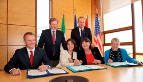
The inaugural meeting of OKEANO was held on 7-8 March at the JPI Oceans Secretariat in Brussels, with representatives from Argentina, Belgium, Brazil, Cabo Verde, France, Germany, Ireland, Morocco, Norway, Portugal, South Africa and Spain in attendance.
 Participants at the inaugural meeting of OKEANO held on 7-8 March at the JPI Oceans Secretariat in Brussels
The kick-off meeting, attended by project partners and representatives of the European Commission, focused on outlining detailed methodologies for achieving the project’s strategic objectives.
Dr Niall McDonough — director of policy, innovation and research services at the Marine Institute and coordinator of Okeano — chaired the meeting, with Dr John Bell, director of healthy planet at the European Commission outlining the vision for the next phase of the alliance.
Participants discussed the work plan for the CSA, emphasising inclusivity, international cooperation and active societal engagement. The importance of facilitating access to a diversity of relevant data, knowledge, expertise, capacities and resources was addressed, positioning Okeano as a pivotal point of contact to link scientists, researchers, public and private stakeholders, including civil society and youth.
“The Okeano project is ready to support and contribute to the goals of a growing and dynamic alliance,” Dr McDonough said. “Through its range of planned activities and strong international partnership, we are committed to reaching and empowering communities across the entirety of the Atlantic to respond to the complex challenges presented by issues such as climate change and ecosystem protection and restoration.”
Focus areas of Okeano include:
- Enhancing governance and coordination — led by the Marine Institute (Ireland): Providing professional support and coordination for the All-Atlantic Ocean Research and Innovation Alliance governance, organisation, monitoring and outreach activities.
- Facilitating dialogue across stakeholders — led by the AIR Centre (Portugal): Fostering collaborations with different organisations, and facilitating structured dialogue and coordination at local, national, international and multilateral levels between AAORIA and relevant stakeholders.
- Supporting and consolidating existing initiatives — led by IFREMER (France): Supporting and consolidating existing AAORIA initiatives, including capacity building for early-career ocean professionals (ECOPs) and youth to promote sustainability and community engagement along the Atlantic Ocean shores.
- Development of a Strategic Research and Innovation Agenda — led by KDM (Germany): Developing an All-Atlantic Strategic Research and Innovation Agenda aligned with the priorities identified in the AAORIA Declaration to foster knowledge exchange, innovation, and benefit to local communities across the Atlantic.
- Maximising impact through communication and outreach — led by JPI Oceans (Belgium): Maximising the impact of the Okeano CSA and supporting communication of AAORIA through effective dissemination, exploitation, and communication measures.
- Co-design and implementation of All-Atlantic Fora — led by the Marine Institute (Ireland): Co-designing and implementing international All-Atlantic Ocean Research and Innovation Fora to strengthen scientific cooperation and shared goals as outlined in the AAORIA Declaration.
Looking ahead, Okeano aims to foster a robust All-Atlantic Ocean Research and Innovation community, promoting cooperation, innovation and sustainable development across the Atlantic basin. By leveraging the collective expertise and resources of its diverse consortium, Okeano believes it is poised to support AAORIA in continuing as a long-lasting and robust community.
#MarineScience - A multinational team of ocean exploration experts returned to Galway on World Ocean Day (Friday 8 June) after spending the last few weeks exploring and mapping the Charlie-Gibbs Fracture Zone of the Mid-Atlantic Ridge.
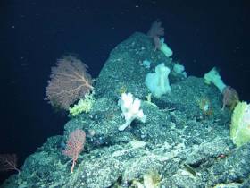
Using the robotic mini-sub ROV Holland I, the TOSCA (Tectonic Spreading and the Charlie-Gibbs Fracture Zone) research team led by Dr Aggie Georgiopoulou of UCD collected “spectacular” film footage of sponge gardens.
In another first for deep-sea exploration, the marine science team on board the RV Celtic Explorer also found more than 70 skate eggs in a nursery some 2,000 metres below the surface.
“Up to 150 rock and sediment samples amounting to roughly 200kg along with 86 hours of video footage and over 10,000 square kilometres of the zone were also mapped, which is almost the size of Co Galway and Co Mayo together,” Dr Georgiopoulou said.
The Charlie-Gibbs Fracture Zone was mapped for the first time in 2015 on the RV Celtic Explorer as one of the key projects launched by the Atlantic Ocean Research Alliance, following the signing of the Galway Statement on Atlantic Ocean Cooperation between Canada, the EU and the US in May 2013.
“The high resolution data produced by Ireland’s INFOMAR programme in 2015, that revealed spectacular landscape with 4,000m-high mounds rising from the seabed to 600m below the sea surface — taller than Carrauntoohil, Ireland’s highest mountain — has been instrumental in our continued research over the last month,” Dr Georgiopoulou said.
The tectonic spreading at the Charlie-Gibbs Fracture Zone consists of two huge parallel cracks in the crust of the Atlantic Ocean running between Ireland and Newfoundland, and is the longest-lived fracture zone in the Atlantic. It is the most prominent feature interrupting and offsetting the Mid-Atlantic Ridge.
“What we have found at the Charlie-Gibbs Fracture Zone surpassed all of our expectations,” Dr Georgiopoulou added. “Exploring three mountain areas, 500-1,000m-high scarps were discovered that have been produced by catastrophic rock avalanches, with giant boulder fields spilling into the fractures.
“Although these fracture zones are similar to the San Andreas fault in the western US and the North Anatolian fault in Turkey and Greece, with large earthquakes taking place there regularly, this is the first time there has been a dedicated geological study in the Charlie-Gibbs Fracture Zone area.”
The TOSCA expedition involved 13 scientists from nine institutions and five different countries including Ireland, the UK, Germany, Canada and Greece.
Experts in seabed mapping, marine geology, oceanography and marine biology, each team will return to their respective Institutes to analyse all the data and work out how the mountains were formed, when and how the rock avalanches take place and how the geology affects the local habitat for marine wildlife.
Marine Institute chief executive Dr Peter Heffernan congratulated the team on their recent discoveries, stating that deep ocean expeditions cannot be taken for granted as we need to better understand the features that make up the ocean seabed.
“With the ocean affecting climate change, global population and seafood demand, we need to map our seabed to define favourable habitats for fishing, key sites for conservation, and safe navigation for shipping.
“The expedition supported by AORA also reflects the value and essential role of international partnerships, particularly with achieving the shared goals of the Galway Statement on Atlantic Ocean Cooperation 2013, which include our ongoing cooperation on ocean science and observation in the Atlantic Ocean,” Dr Heffernan said.
#MarineScience - Five years ago this month, the Galway Statement on Atlantic Ocean Cooperation was signed and the Atlantic Ocean Research Alliance (AORA) between the European Union, Canada and the United States of America formed.
In the time since, the AORA has already been recognised as a success story in the Atlantic area, highlighting international best practices, and promoting the key priorities of the European Union’s Atlantic Strategy and Atlantic Action Plan, embodied in the Galway Statement and its potential support to the Blue Economy.
Today there are more than 500 research teams working in the Atlantic Ocean. Transatlantic co-operation has been embedded and embraced at the heart of the scientific teams working together in Atlantic-wide field campaigns on seabed mapping, ocean observation, seafood, weather, climate and polar research, marine biotechnology and marine spatial planning.
The Galway Statement has also provided the first step in all-Atlantic co-operation, leading to the signing of the Belém Statement on Atlantic Research & Innovation Cooperation between the European Union, South Africa and Brazil. An all-Atlantic research community is also being built.
New transatlantic institutional structures have been formed, including an Ocean Frontier Institute in Canada which includes European and US partners.
Speaking about the achievements to date, Dr Margaret Rae, director of AORA co-ordination and support action at the Marine Institute, said: “AORA is using the latest technology to map the Atlantic, making groundbreaking discoveries like previously uncharted undersea volcanoes and mountains, circulation patterns, and more.
“Our coordinated efforts are helping to create a blueprint for the next generation of ocean observation. And there’s still much to uncover, from new sources of energy and food to lifesaving medicines found in unexpected sources.
“By learning all we can about our oceans, we can create a world with better navigation, weather prediction, smarter search and rescue, health, and a thriving seafood industry that will feed generations to come.”
Transatlantic research teams with Horizon 2020 funding have unearthed new discoveries and knowledge:
Seabed Mapping
- Completed seven opportunistic transatlantic surveys by Irish, Canadian, French and Fugro vessels, resulting in discoveries of uncharted seamounts kilometres high, deep sea volcanoes, and ridges some hundreds of kilometres in length.
- Developed a collaborative model for industry, research and government to promote Atlantic seabed mapping and open data.
- Encouraged private sector participation for public good, resulting in Fugro contributing more than 65,000 sq km of high resolution data. Fugro maps the seabed while transiting between offshore projects.
Ocean Observation
- Completed an analysis of Atlantic-wide observation system capacities/gaps.
- For the first time a team has formed to develop a blueprint for an Atlantic-wide integrated ocean observing system with wide Atlantic participation.
Atlantic Ecosystems
- Co-ordinated expeditions to map deep-sea Atlantic ecosystems and advanced knowledge of key species, ecosystems and processes.
- Discovered modern Atlantic Ocean circulation which is atypical of the longer term.
- Deployed new sensors in eastern subpolar North Atlantic to enable key advancements in understanding of ocean physics interactions.
- Provided scientific evidence that temperature change, acidification, fisheries and their cumulative effects pose the greatest risks to ecosystem services.
- Successfully tested a generic Marine Spatial Planning (MSP) framework to assess spatially managed areas (SMAs) across the North Atlantic.
Seafood
- For the first time, climate vulnerability assessments of North Atlantic fish and shellfish, including the human communities dependent on these have been rigorously compared across the EU, US & Canada – strengthening scientific cooperation and building better forecasts.
- Made the first steps to use marine algae to build ‘blue belts’ for carbon/nitrogen sequestration and sustainable aquaculture.
Ocean Education
- Developed a transatlantic ocean literacy strategy and a range of new ocean educational materials (videos, teaching modules, infographics).
Weather, Climate & Polar Research
- Worked together to study Arctic warming impacts, ecosystem productivity and ocean-climate dynamics to give new understanding to local populations.
- Facilitated co-operative understanding of the impact of a changing Arctic on weather and climate across the northern hemisphere.
- Worked with public and private users of climate information to help them incorporate uncertain scientific evidence into real-world decision-making processes.
For more information see www.atlanticresource.org.
Canada’s Environment & Climate Change Minister Visits Marine Institute To Talk Atlantic Ocean Collaboration
#MarineScience - Canada’s Minister of Environment and Climate Change, Catherine McKenna, was at the Marine Institute headquarters in Oranmore yesterday (Friday 13 October) to discuss collaborations under the Atlantic Ocean Research Alliance.
The Marine Institute meetings were part of a tour by Minister McKenna to London and Dublin to advance discussions on clean growth and climate action.
Minister McKenna was accompanied by Canadian Ambassador to Ireland Kevin Vickers and met with the Marine Institute’s chair Dr John Killen and chief executive Dr Peter Heffernan, members of the senior management team and scientific staff.
The meeting provided an opportunity to discuss existing projects and opportunities to further Ireland and Canada’s collaboration on Atlantic Ocean research and climate impacts.
“Transatlantic cooperation is essential to broadening our scientific understanding of the Atlantic Ocean and helping to ensure it remains healthy and productive,” said Dr Heffernan. “It’s hugely important for Ireland and brings us closer to achieving the goals of the Galway Statement on Atlantic Ocean Co-operation signed here at the Marine Institute Galway in May 2013 by the EU, USA and Canada.
“The goal is to work together, share expertise and advance our science goals to promote the sustainable management of our Atlantic ocean for the benefit of all.”
Since the signing of the Galway Statement, the Marine Institute says it has led initiatives to further this collaboration in areas including Atlantic seabed mapping and climate change research, and is leading the EU H2020-funded Atlantic Ocean Research Alliance - Coordination and Support Action.
Speaking on her visit to the Marine Institute, Minister McKenna said: “Canada and Ireland are natural partners on marine research. Canada recognises that Atlantic research will be more effective if we work together and on both sides of the ocean.
“The knowledge we gain benefits us all, and all and is crucial to helping us to meet the challenges we face, in particular climate change, food security and new sources of energy.”
Ambassador Vickers added: “We are now entering a new era of transatlantic co-operation that will enable us to achieve great things together in the coming years.
“We are raising the importance for ocean discovery above sectoral interests and putting marine research on a new global level that transcends national borders, making literal the bonds connecting Ireland and Canada, to increase our knowledge of the ocean that joins us and to maximise the innovation potential it affords us.”


. He learned his sailing in the Royal Cork at Crosshaven but left Ireland (as did many others) in 1985 and is now so into America’s West Coast sailing scene that he owns a classic Cal 40")


 Michael Murphy Schull Harbour Sailing Club (SHSC), Eric Coogan Heineken Ireland, Mark Murphy, Commodore SHSC, Jack Allen SHSC, Carmel O'Regan SHSC, Cornelious Ndlovu, Schull Harbour Hotel Operations Manager and Derval Murphy SHSC")

