


Displaying items by tag: Celtic Explorer
Irish Marine Research Vessels, the Celtic Voyager and Celtic Explorer Celebrated in 'Oceans of Learning' Programme
Oceans of Learning, a collaboration between the Marine Institute and Government departments and organisations across Ireland, this week focuses on Ireland’s national marine research vessels, the Celtic Voyager and Celtic Explorer.
The RV Celtic Voyager came into service in 1997 as Ireland’s first custom-built multi-purpose research vessel. Her purpose was to facilitate the sustainable development of the country’s vast marine resource.
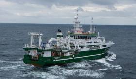
In 2003, the RV Celtic Explorer was commissioned as Ireland’s first deep sea research vessel. At the time of its launch, the Celtic Explorer was the quietest research vessel in the world, meeting international underwater noise requirements essential for fisheries research.
Dr Paul Connolly, CEO of the Marine Institute said, “The Celtic Voyager and Celtic Explorer have been central to the Marine Institute’s work and research, enabling us as a nation to engage in high quality marine science and to actively contribute to international research programmes.
“The new national marine research vessel, RV Tom Crean, comes into service in 2022, replacing the Celtic Voyager. As we look forward to a bright future with the Tom Crean and Celtic Explorer, we take a moment to appreciate the legacy of the Celtic Voyager. The vessel has served us well over the past quarter of a century, providing marine scientists, researchers and crew members with many years of experience at sea, and enabling us to deepen our ocean knowledge.”
The RV Celtic Voyager replaced the 21 metre RV Lough Beltra, which had originally been a fishing trawler. Upgrading to a 31-metre research vessel was the beginning of a new era in marine science in Ireland, as the Marine Institute was able to provide a purpose built platform that could operate further out in Ireland’s ocean territory.
The research vessel has played an essential role in fisheries scientific research, and a vital role in seabed mapping in Irish waters, as part of the INFOMAR programme. More than 200 shipwrecks around the coast of Ireland including the RMS Lusitania, have been mapped by the Celtic Voyager. In 2007, the survey of Galway Bay revealed for the first time a detailed seafloor and geology of the bay, confirming the location of the Galway Bay Fault.
Over close to 25 years, the Celtic Voyager has completed more than 600 surveys, enabled more than 5,000 science days and sailed in excess of 400,000 miles.
The 65 metre RV Celtic Explorer is designed for fisheries acoustic research, oceanographic, hydrographic and geological investigations as well as buoy/deep water mooring and ROV (Remotely Operated Vehicle) Operations. The vessel has a maximum endurance of 35 days offshore and can accommodate up to 35 personnel, including 20-22 scientists.
Expeditions on the RV Celtic Explorer in Irish and international waters have resulted in many exciting discoveries - from deep-water shark nurseries, cold-water coral reefs, to hydrothermal vents fields in the mid-Atlantic.
As part of Oceans of Learning, the Marine Institute’s Voyages video series profiles the people whose work is intertwined with Ireland’s national research vessels. Voyages shares insights into the people behind the science of our seas – Dr Louise Allcock, Professor of Zoology at NUI Galway, and David O’Sullivan, INFOMAR Programme at the Marine Institute – modern explorers on a voyage of discovery to safeguard the ocean and our future.
The Oceans of Learning series on marine.ie offers online interactive activities, videos and downloadable resources all about our ocean. A #SeaToMe social competition will encourage people across Ireland to share what the sea means to them for the chance to win weekly prizes.
Through Oceans of Learning, the Marine Institute comes together with Government Departments and organisations across Ireland including Bord Iascaigh Mhara, Bord Bia, Met Éireann, Commissioners of Irish Lights and EPIC Irish Emigration Museum, to celebrate and highlight the vital role our ocean plays in all of our lives.
Loss Ness Mometer & Other Seismometers Retrieved by Dublin Institute of Advanced Studies Expedition
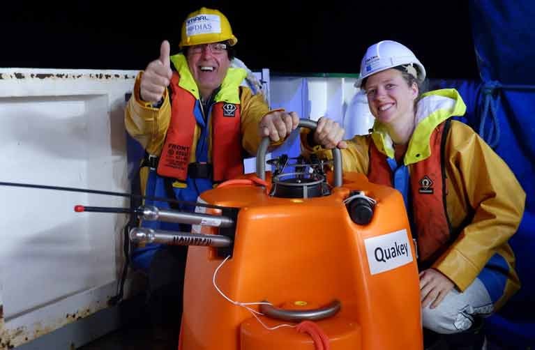
Marine Scientists on the RV Celtic Explorer have collected a network of seismometers recording valuable data over the past 19 months in Irish, British and Icelandic waters.
The 18 seismometers had been deployed in 2018 over a 1500 kilometre area from north to south and over 1,000 km of sea from east to west as part of a project run by the Dublin Institute of Advanced Studies (DIAS).
As Afloat previously reported, a “skeleton” team of six scientists and a small crew on the Marine Institute research vessel went to sea last month to retrieve them and returned to Galway this week after three weeks at sea.
Team leader Dr Sergei Lebedev, DIAS seismologist, said the data captured by the seismometers would “shed light on the nature, occurrence, and frequency of earthquakes off our coast, and is fundamental to our understanding of them”.
“The current nature and history of the ocean floor along Ireland's coast is key to our understanding of how the Atlantic evolved and is evolving, and this is important for better understanding both the natural hazards and natural resources offshore," he said.
"For example, slope failures triggered by earthquakes can generate tsunamis in the Irish offshore territory – the data will give us new insights into this hazard,” he said.
The expedition was “time-critical”, as there were fears the data would be lost if the sensors were not retrieved. Physical distancing measures as part of HSE guidelines on the Covid-19 pandemic were in place for the expedition, according to the DIAS team.
"The seismometers have waterproof memory sticks with recordings of earthquakes off the coast of Ireland. To date, these have been poorly understood, but we know they are generally larger than the ones Ireland has onshore. The new data will give us much greater insights into earthquake mechanisms and, also, into the structure of the Earth's interior,” Dr Lebedev said.
"The instruments have made continuous recordings from the last 19 months of the songs of the great baleen whales, including the blue, fin, humpback and North Atlantic right whales. These unique recordings will build our understanding of the migration patterns of the Earth's largest animals and their acoustic environment, known to be crucially important for them,” he said.
Before the seismometers were deployed in 2018, DIAS ran a competition inviting secondary school students to name each one. Suggestions included “The Dude”, “Gráinne”, “Luigi” and “The Loch Ness Mometer”.
During the retrieval expedition, the research team hosted live video links with school classes from St Francis National School in Wicklow, along with St Joseph's College in Tipperary, and a school in Calabria, Italy.
Ireland's national research vessel, the R.V. Celtic Explorer will set sail this evening from St. John’s, Newfoundland and Labrador, (8pm Newfoundland/11:30pm Ireland), where last June it launched the very first seabed mapping expedition under the Atlantic Ocean Research Alliance.
The survey takes place May 11-21 with graduate students and early career researchers representing Europe (Ireland), Canada and the United States joining a team of international experts to map some 12000km2 of un-surveyed seafloor from the deepest parts of the Atlantic Ocean. Ireland’s national seabed mapping programme, INFOMAR launched a travel bursary called the Atlantic Seabed Mapping scholarship, AtSeaMap, to help support student researchers to come onboard.
This is the fourth seabed mapping survey to take place under the Atlantic Ocean Research Alliance. Xavier Monteys, Geological Survey of Ireland, will lead a team of 12 international scientists, who will map a transect of the Atlantic seafloor between St. John’s, Newfoundland, and Galway, Ireland. Together they will investigate discoveries from previous expeditions,while training the next generation of young seabed mappers through an innovative series of ocean research training delivered on-board.
Koen Verbruggen, Director, Geological Survey of Ireland (GSI) and Dr Peter Heffernan, CEO Marine Institute, the partner organisations delivering the INFOMAR programme, welcomed the survey and the introduction of AtSeaMap.
Koen Verbruggen said: “The INFOMAR scholarship, supporting European, US, and Canadian student participation, is a key step towards developing expertise, sharing knowledge, and raising awareness of the integral role of the Atlantic Ocean in each and every one of our daily lives.”
Dr Peter Heffernan added, “The Atlantic Ocean influences our lives in many different ways from climate, environment, energy, transport, telecommunications, to food on our tables. It’s our maritime highway. Amazingly, we just don't yet have the roadmap. AtSeaMap provides a unique opportunity for students from Europe, Canada and the USA to be part of a significant initiative to begin to build comprehensive maps of the Atlantic Ocean. ”
The survey supports the Galway Statement on Atlantic Ocean Cooperation, the goals of which are to join the resources of its three signatories to better understand the North Atlantic Ocean, to promote sustainable management of its resources, and to promote citizens’ understanding of the Atlantic through ocean literacy.
Dr Heffernan, who is the coordinator of the Atlantic Ocean Research Alliance Coordination and Support Action, added: “This survey and those to follow will make a significant contribution towards delivering on commitments made in the Galway Statement and represent an important stepping stone to building a comprehensive mapping campaign for the Atlantic Ocean.”
The survey is called TRASNA, which is the Irish word for “crossing" and stands for Trans-Atlantic Survey North-Atlantic. The scientific team and students will blog about their experience on the RV Celtic Explorer on www.atlanticresource.org/aora/trasna where you can follow their progress across the Atlantic or use #TRASNA.
The early stage researchers joining the survey as part of the AtSeaMap initiative are Jamie Maxwell, National University of Ireland Galway, Ireland; Peter MacIntosh, Memorial University, Newfoundland and Labrador, Canada; and Rachel Wireman, College of Charleston, USA.
The Canadian Coast Guard vessel Louis St. Laurent will build on this work later this summer sailing from Halifax, Nova Scotia, Canada on 22 July and due to arrive in Tromsø, Norway 5 August.
The INFOMAR Atlantic Seabed Mapping scholarship, AtSeaMap, is funded by the Department of Communications, Energy and Natural Resources.
The Marine Institute is leading the Horizon 2020 funded project -The Atlantic Ocean Research Alliance Coordination and Support Action – to support the implementation of the Galway Statement, signed at the Marine Institute, Oranmore 24th May 2013.
Major Upgrade To Scientific Equipment On RV Celtic Explorer

#MarineScience - The marine research vessel Celtic Explorer is back in the water with a new suite of hydrographic and geophysical sonar systems.
According to the Marine Institute, the new instruments were installed during an extensive refit in the A&P yard in Falmouth, which began on 29 December under the supervision of P&O Maritime (Ireland) Ltd.
The main work carried out during the refit was the installation of state-of-the-art sonar systems for bathymetric mapping in deep and shallow waters, and the installation of a deepwater sub-bottom profiler.
Adjustments were also made to the hull to fit the Kongsberg EM302 multibeam system and an IXSEA Echoes sub-bottom profiler.
These systems will enhance the seabed mapping capabilities of the Celtic Explorer, with the EM302 echo sounder designed to perform mapping with high resolution and accuracy to depths of 6km. The sub-bottom profiler can operate at the same depths to examine and profile surface bedrock layers and sediments.
The vessel's drop keel has been fitted with an EM2040 multibeam system – the same as that fitted to sister vessel the Celtic Voyager last year – to carry out high resolution seabed mapping in shallower waters. The vessel's positioning and motion reference systems were also upgraded to the highest standard to allow the vessel to operate the new equipment to the required accuracy.
The two-and-a-half-yearly refit included major mechanical work such as the removal of the rudder for inspection and repair and overhaul of the stern thruster. The entire vessel was painted; cabins, laboratories and common areas were refitted; and minor repairs carried out as well as an overhaul of essential systems.
The Celtic Explorer will complete a survey in the North Sea and Baltic Sea before beginning sea trials of the new equipment in Irish waters in February. The capability of the new equipment will be tested in the deep waters off Ireland's West coast under the supervision of scientists from the Marine Institute's Advanced Mapping Services (AMS) team.
Once the new systems have been calibrated and tested, they will be used extensively this year, including on fisheries acoustic surveys where their water column capability will be used to study the aggregation morphology and vessel avoidance behaviour of pelagic fish species, as part of a new PhD study.
The new systems will also be used to map the deep Atlantic seafloor during passage to and from Canada in April-May this year, and will be key during two deepwater ROV surveys this year, one led by University College Cork studying cold water coral reefs, and another led by University College Dublin studying deepwater thermal vent sites on the Mid-Atlantic Ridge.
The Celtic Explorer will deliver an intensive programme of activities in 2015 with a packed schedule to 17 December.
Beyond 2015, the systems will be used extensively to map the Celtic Sea, which will provide valuable data for the sustainable development of Ireland's fisheries as well as allowing Irish scientists the opportunity to play a pivotal role in future research opportunities in the deeper waters of the Atlantic Ocean.
Science Students Study Cold Water Coral Ecosystems In Irish Waters

#MarineScience - The national research vessel RV Celtic Explorer has become a ‘floating university’ for 14 postgraduate students from seven countries – including Ireland – who have a unique chance to study cold water coral systems in their living environment in Irish waters.
The Atlantic Summer School, which runs till 17 September, involves a multidisciplinary investigation of cold water coral ecosystems of the Belgica Mound Province, which is a special area of conservation (SAC) some 150km south-west of Ireland.
As previously reported on Afloat.ie, the initiative is a collaboration between the Strategic Marine Alliance for Research and Training (SMART) in Ireland and the Alfred Wegener Institute Helmholtz Centre for Polar and Marine Research (AWI) in Germany.
“Cold water corals live at ocean depths of around 1,000m and build reefs which over millennia can reach up to 300m high," explained Dr Pauhla McGrane, national co-ordinator of SMART Ireland. "These giant coral mounds act as biological “hot-spots” and provide habitats for a variety of marine life.
“The Atlantic Summer School will enable postgraduate students to survey these mounds and collect data that will ultimately increase our understanding of these unique environments," she added.
“It’s not everyday that students get a chance to explore the ocean’s seabed gaining vital skills for exciting careers”, said Prof Andy Wheeler, Head of Geology at the School of Biological, Earth and Environmental Sciences in University College Cork. “Whenever we get a chance to get out there, we always find something new which changes our perspective on how this planet functions.”
The Atlantic Summer School includes a one-day sea survival training course for marine science students at the National Maritime College of Ireland in Cork, as well as distance learning and pre- and post-survey workshops at UCC and NUI Galway.
“This pooled infrastructure and expertise from Ireland and Germany’s higher education institutes provides an incredible chance for postgraduates to get the necessary practical experience and develop networking opportunities they need early in their careers,” said Prof Karen Wiltshire, vice-president of AWI.
“We are all delighted to be part of this strategic collaboration, which will ultimately develop career pathways and mobility for students between the island of Ireland and Germany and increase multidisciplinary research capacity in Atlantic nations.”
Marine Institute chief executive Dr Peter Heffernan congratulated all involved in the initiative, saying: “It’s essential to learn more about the ocean as it the life support system for our planet. We’re proud to be part of this and to support this unique training opportunity for our future ocean explorers.”
The 2015 Atlantic Summer School will take place onboard the RV Polarstern on an Atlantic meridional transect from Bremerhaven, Germany to Cape Town, South Africa and will provide eight Irish marine science students with the opportunity to conduct research.
For further information visit the SMART website or contact [email protected].

#MarineScience - Applications are now invited for the Atlantic Summer School 2014 to be held on board Irish national research vessel RV Celtic Explorer from 11-17 September.
The school is a collaboration between the Strategic Marine Alliance for Research and Training (SMART) and the Alfred Wegner Institute for Polar and Marine Research (AWI), with ship time provided by the Marine Institute, and is open to all marine-related postgraduate students (MSc and PhD) from across the island of Ireland and Germany.
The 2014 Summer School aims to build capacity in offshore marine research by providing early-stage career scientists with the knowledge and skills necessary to act as chief scientists on research surveys.
Participants will conduct a multidisciplinary investigation of cold water carbonate (CWC) ecosystems off the Belgica Mound Province, which is a Special Area of Conservation (SACs) approximately 100km southwest of Ireland.
In addition to the five days of seagoing research, the school includes pre-survey meetings via Skype, pre-cruise preparation in Cork and post-survey data analysis and reporting in Galway.
Course content will include:
- Pre-survey meetings and lectures on the study site, SACs and CWC ecosystems.
- Practical shore-based workshop designing and planning the survey.
- Deployment and operation of novel equipment and instrumentation.
- Acquisition, processing and archiving of samples.
- On-board evening survey meetings and lectures.
- Post-survey data processing, analysis and open source publishing.
- Reporting initial findings through working groups.
The collaboration is designed to forge mobility pathways for early career researchers between Ireland and Germany and serve as an excellent networking opportunity for all participants.
This is the first of a series of summer schools that will alternate between Irish and German research vessels, with the 2015 school taking place on the RV Heincke.
Training will be overseen by experts from University College Cork, NUI Galway, University of Ulster, Alfred Wegner Institute and SMART.
Online application forms must be completed and received by 5pm CET on Friday 6 June 2014.
For further information and an online application form please visit the Atlantic Summer School website or contact [email protected].
Please note that all travel and shore-based accommodation costs are the responsibility of summer school participants. Successful applicants must have or plan to secure a valid Medical Certificate approved by the state (ENG11 in Ireland) and Personal Survival Techniques (PST) certificate approved under the STCW 78/95 convention.
Children Get Onboard RV Celtic Explorer in Galway

#marinescience – Over seven hundred class students from Galway, Roscommon and Mayo are visiting the RV Celtic Explorer in Galway over the next two days (Thursday 5th & Friday 6th December 2013). Having entered the "Exploring the XTRA-Ordinary Writing Competition" earlier this month, students demonstrated their awareness of Ireland's research vessel RV Celtic Explorer and their understanding of Ireland's marine life and ocean.
The overall winning entry by Ciara MacDonald, Scoil Mhuire Oranmore was a poem called A fish is what I'm destined to be. Ciara demonstrated a unique approach to her awareness of Ireland's marine life. She describes what it would be like to be a fish, starfish and dolphin and in fact maybe her destiny is to be on the Celtic Explorer.
Dr Peter Heffernan, CEO of the Marine Institute said, "The competition captured the imaginations of many students, revealing their understanding of the important influence the ocean has on our lives. Learning about our ocean at a young age fosters engagement with the sea which is a key goal of 'Harnessing Our Ocean Wealth - An Integrated Marine Plan for Ireland'. The sense of wonder and curiosity about the sea was clear from the many wonderful entries we received and I hope the students enjoy their time onboard the Celtic Explorer in Galway".
Welcoming the students and teachers to the RV Celtic Explorer, Aodhan Fitzgerald, from RV Operations at the Marine Institute, congratulated the students on their knowledge about the marine, "We're delighted to be able to show the work of our marine scientists first hand. As the research vessel is at sea for over 300 days of the year it is a welcomed opportunity to be able to facilitate the open days for so many of the students who entered the competition".
While on board the research vessel, demonstrations of how Ireland's 220 million acre seabed territory and inshore waters are mapped will be shown. Students will also learn about techniques for identifying and ageing fish in the wet-lab as well as seeing the Bridge area where the Captain Dennis Rowan will explain how the ship is run.
Students will also see the Remotely Operated Vehicle (ROV) Holland 1, which recently captured underwater footage and samples of novel deep sea habitats in the Whittard Canyon system. The inshore research vessel, RV Celtic Voyager will also be alongside at Galway docks and will be visited by some of the Children.
Rare Ocean Wildlife a Treat for Atlantic Explorers
#MarineWildlife - An Irish marine research vessel has returned from an Atlantic Ocean voyage with tales of exotic new wildlife in the depths southwest of Ireland.
As The Irish Times reports, remarkable finds such as two-century-old clams and oysters, an endangered sailfin roughshark, a massive sponge and a giant hydroid - a rare relation to jellyfish and coral - were among the marine wildlife recorded by researchers on the RV Celtic Explorer in the Whittard Canyon on the Irish Atlantic margin.
Dr Louise Allcock of NUI Galway, who led the Marine Institute team on the ocean survey, said it was "part of an ongoing effort to understand Ireland's deep-sea biodiversity".
In a similar process to that used by the group who made new marine discoveries at Rockall recently, the Marine Institute team used a submersible remotely operated vehicle (ROV) to collect images and samples from the ocean chasm that's twice as deep as the Grand Canyon.
Some of those samples may aid in antibacterial and pharmaceutical research, the team explained.
The Irish Times has much more on the story HERE.
In other marine wildlife news, the Belfast Telegraph fears that "chilly seas" could be keeping basking sharks at bay from Northern Ireland's waters, as the first sighting of the year was recorded last month.
Reports from various sources indicate that water temperatures are 2 to 3 degrees lower than normal for this time of year, inhibiting the blooming of plankton that are the main source of food for the second-largest fish in the sea.
And the numbers say it all, with the Irish Whale and Dolphin Group (IWDG) confirming only 19 sightings of basking sharks around the island of Ireland as of the end of May this year, compared to 84 in the same period in 2012 - although more were spotted earlier this month off Malin Head, as the video below shows:
Calls Now Open For Marine Reaearch Funding Under EUROFLEETS2

#MarineScience - Applications are now being invited under EUROFLEETS2, an EU-funded project providing scientists with 200 fully funded days of ship-time and 104 fully funded days of marine equipment to carry out ship-based research activities within any field of marine sciences.
EUROFLEETS2 - which had its kick-off meeting gathering more than 60 marine scientists and fleet operators in April this year - aims to bring together the European research fleets to enhance their co-ordination and promote the cost effective use of their facilities.
The Marine Institute’s research vessels, the RV Celtic Explorer and the RV Celtic Voyager, are both available to researchers through the EUROFLEETS ship-time call. Irish researchers can apply for ship-time on these and other European vessels participating in EUROFLEETS2.
EUROFLEETS2 invites applications for the following marine research funding opportunities:
Super-Integration: This call seeks to fund a truly cross-cutting proposal, multidisciplinary, multiyear and/or multiplatform, which needs to mobilise a combination of EUROFLEETS Research Vessels (RVs) together with other appropriate scientific tools like nationals RVs, research planes or onshore infrastructures with their own EC or national funding. All EUROFLEETS RVs and equipment are available for this call. More information at www.eurofleets.eu/np4/59
Embarked Equipment: This call offers fully funded marine equipment time within participating scientific marine equipment (two 3D HD TV cameras, two ROVs and the sea floor drill rig MARUM-Mebo) to be deployed from RVs or from underwater vehicles funded by other sources than EUROFLEETS2. More information at www.eurofleets.eu/np4/60
The application deadline for both funding opportunities is 16 September 2013.
EUROFLEETS2 is a Research Infrastructures project under the seventh Framework Programme of the European Commission. For more information and eligibility criteria visit www.eurofleets.eu.
#MarineScience - Gathering more than 60 marine scientists and research fleets operators from all European eco-regions, the kick-off meeting of the European project EUROFLEETS2 was held in Brest, France from 19-21 March last at the invitation of the French Research Institute for the Exploitation of the Sea (Ifremer) and the French Polar Institute Paul-Emile Victor (IPEV).
Thirty-one research organisations, research fleet managers, universities, and industrialists from 20 EU members states or associated countries participate in the EUROFLEETS2 project, whose main objective is the integration of research fleets currently managed at national level.
This project amplifies the effort initiated since 2009 with EUROFLEETS, which ends in August this year. Again co-ordinated by Ifremer, EUROFLEETS2 has a strong operational component. The project receives significant funding from the European Commission (€9 million of a total budget of approximately € 10.8 million) over four years.
“This provides a fantastic opportunity for Irish researchers to access a wide variety of vessel and equipment across Europe,” said Aodhan Fitzgerald of the Marine Institute’s Ocean Science Services Team. “The Marine Institute is proud and pleased to offer ship time on the national research vessels RV Celtic Explorer and RV Celtic Voyager as part of this project.”
EUROFLEETS2 is organised into three complementary activities – trans-national access; joint technological research; and networking - promoting information sharing, identification of new collaborative frameworks, development of common software tools and also testing innovative integration schemes.
Trans-national access offers the opportunity, fully funded by EUROFLEETS2, to international scientific groups to access research vessels on the basis of scientific excellence of the cruise proposals. After seven European calls for ship-time organised within targeted maritime regions, these scientific groups will embark on eight global/ocean and 14 regional European research vessels distributed all over European and world seas and oceans.
Two new initiatives are also planned in EUROFLEETS2: the first aims to attract scientific leaders and/or non traditional end users to make proposals for a flagship project involving several vessels (‘super-integration’ call for ship-time), while the second makes available an original set of five underwater vehicles or scientific embarked equipment.
Joint research, through dedicated actions, contributes to more modern infrastructures and enriched information services. Three key activities are considered: the definition of regional research vessels guidelines and generic designs, the development of innovative functionalities for underwater systems, and the implementation of data acquisition systems in standardised formats, contributing to a higher interoperability between research vessels.
Networking activity will consist in working groups for a better co-ordination of European research fleets. It will aim to establish a common strategic vision including polar research fleets, experiment new integration schemes like the virtual fleets and strengthen links with industry. Floating universities will complement the actions already undertaken for the training of young European scientists.
The long-term objective of EUROFLEETS2 is to prepare the insertion of a group of innovative and inter-operable regional research vessels in the ESFRI(European Strategic Forum on Research Infrastructures) roadmap.
Calls are now open for fully-funded ship time in polar and subpolar regions as well as for expressions of interest in super-integration.
For the former, EUROFLEETS2 can provide 200 fully funded days of ship time and 104 fully funded days of marine equipment to carry out ship-based research activities within any field of marine sciences. The application deadline is 24 May 2013.
As for the latter, the call seeks a cross-cutting proposal that needs to mobilise a combination of EUROFLEETS research vessels together with other appropriate scientific tools like national research vessels, research planes or onshore infrastructures with their own EU or national funding. All EUROFLEETS research vessels and equipment are available for this call. The expression of interest is not binding but desirable.
The deadline for applications is 15 May 2013. Logistically accepted pre-proposals will be invited to submit a full proposal from 14 June till 16 September 2013.
For more information and eligibility criteria visit www.eurofleets.eu.


 LÉ Aoibhinn and LÉ Gobnait at the Naval Service Base at Haulbowline, Cork Harbour. They are to carry out fishery duties, etc on the Irish Sea, east and south-east.")


