


Displaying items by tag: Coastal Community
Coastal Communities are the focus this week on the Marine Institute’s Oceans of Learning series. The Marine Institute and partners are celebrating our world’s shared ocean and our connection to the sea in a 10-week series, sharing news and offering online interactive activities, videos and downloadable resources on a new marine topic each week
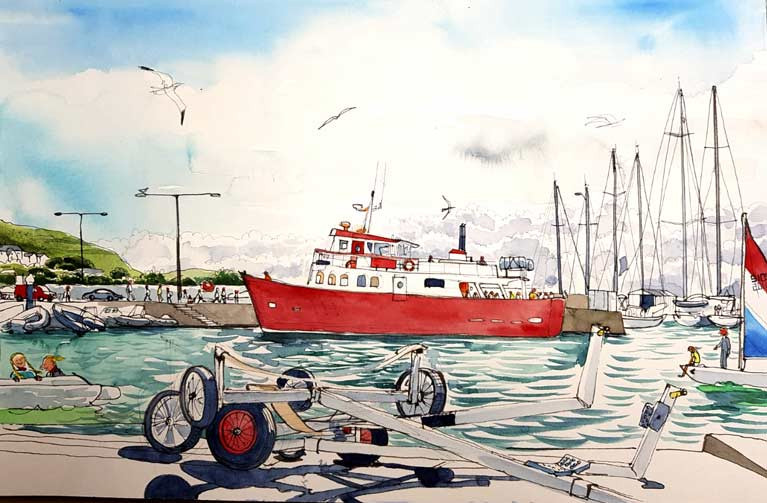
A series of watercolour illustrations and interviews have captured the importance of the ocean to coastal communities in Ireland and Wales as part of BlueFish, an EU-funded project. Through engaging with coastal communities using art, BlueFish links knowledge and understanding of the marine resources and the potential impacts of climate change on the Irish and Celtic Sea ecosystem
"Without the ocean, we wouldn't have a living: it's our only source of income in this rural part of Ireland. Climate change is definitely happening: growth periods are longer than they ever were. But higher water temperatures and higher rainfall could be catastrophic for our business," according to Oyster and mussel fishermen, Cromane, Co. Kerry.
The marine science research project BlueFish is a partnership between six organisations in Ireland and Wales including the Marine Institute, University College Cork, Bord Iascaigh Mhara, Bangor University, Aberystwyth University and Swansea University.
Urban sketcher Róisín Curé and a scientist from the Marine Institute visited coastal communities in Ireland and Wales. Róisín created watercolour illustrations showing the people whose livelihoods are dependent on the ocean and who have a profound and immediate interest in the effects of climate change. Also interviewed were fishermen, restaurateurs, shellfish producers, operators in the tourism sector and seafarers to gather an understanding about how they benefit from the ocean and their thoughts on climate change. The results of the interviews and art through watercolour illustrations created an accessible way for the public to understand the importance the ocean has on livelihoods in coastal communities.
By bringing artists and marine scientists together and working closely with project partners and coastal communities, the Marine Institute has developed a structured portfolio of artwork that is intended to promote a better understanding of the impacts of climate change on ecosystem goods and services; to demonstrate how climate change may impact these; and to highlight the wider societal benefits of healthy ecosystems in Irish and Welsh coastal communities that border the Irish and Celtic Sea(s). The artwork produced as part of the BlueFish project can be viewed in this video.
Dr Paul Connolly, CEO of the Marine Institute explained that "a central part of the project was listening to people living and working in coastal communities, and gathering their opinions about climate change and learning about how it might affect their livelihoods. This was a unique opportunity to talk directly to coastal communities and capture their perspectives through art," Dr Connolly said.
By engaging with people and industries dependant on the sea, the information gathered highlighted how they benefit from the ocean, their thoughts on climate change, and particularly how it was going to affect their lives and businesses.
 Dorans on the Pier at Howth in County Dublin. Illustration by Róisín Curé
"Many of the stories reaffirmed the importance of the age-old relationship between people and the sea, noting that the sea is the life-blood which sustains these communities. The general consensus in both Ireland and Wales coastal communities was that climate change is happening. There was an acknowledgement and a realisation amongst the people interviewed that there was a real looming threat to their livelihoods," said Dr Connolly.
Many people commented on how they were seeing changes to their climate in their local communications. A local businessman from the Isle of Anglesey commented, 'in the 38 years I've been working here, the road would have flooded twice a year. Now it floods much more often.'
The Marine Institute’s Oceans of Learning series this week highlights Ireland’s Coastal Communities. Oceans of Learning offers videos, interactive activities and downloadable resources on our coasts and seashore. Commissioners of Irish Lights offers videos on the work they do to ensure safe navigation around our coast and a colouring book on the Great Lighthouses of Ireland. Find out more about Údarás na Gaeltachta and marine businesses in coastal communities through a series of videos. Discover the animals, seaweeds, plants and creatures along the seashore with the Explorers Education Programme’s Seashore Guide Work Book, and explore the habitats of Galway Bay with activities from Galway City Museum. There are also videos on the Marine Institute's shellfish safety programme and our coastal economy, posters and colouring activities about the marine life found along Ireland's coast.
Coastal Community Commitment – Podcast
There are moments and scenes which stand out in your mind. Stamped on mine is the day I went to a coastal village in West Cork and there, on the edge of a cliffside near Barryroe, close to Courtmacsherry Harbour, I saw the remains of a long-abandoned fishing family’s home, where two sons had died in the biggest sea battle of World War One – the Battle of Jutland on the thirty-first of May 1916. A short distance further up the same cliffside from that house, I was shown the home of another family whose son had died in the same battle. And, amazingly, in the parish of Barryroe, six men from the village had died in that sea battle, fought by a hundred thousand sailors in 250 ships of the British and German Navies. Eight thousand of those sailors were killed, including the six men from this village in West Cork. Another 29 sailors from Barryroe survived.
The interest of coastal communities in their history and culture, their pride in their heritage are impressive and are well underlined in this edition of my maritime programme, THIS ISLAND NATION, (click below for podcast) in the process of producing which I am fortunate to meet such communities.
In this edition I meet people from Courtmacsherry and Barryroe on the West Cork coastline and hear how they have researched and, as a result honoured, the amazing linkage between the area and the biggest sea battle of World War One – the Battle of Jutland, which is also described as the biggest sea battle ever. The statistics from it are, in terms of human destruction, terrible.
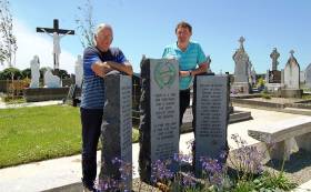
To walk into Lislevane Cemetery in Barryroe and see the memorial to those who fought and died at the Battle of Jutland is an emotional experience.


 linking Spain.")


 Michael Murphy Schull Harbour Sailing Club (SHSC), Eric Coogan Heineken Ireland, Mark Murphy, Commodore SHSC, Jack Allen SHSC, Carmel O'Regan SHSC, Cornelious Ndlovu, Schull Harbour Hotel Operations Manager and Derval Murphy SHSC")


