


Displaying items by tag: Coastal Notes
Kish Lighthouse Original Damaged Base Acquired 50 Years Ago for Greystones Harbour
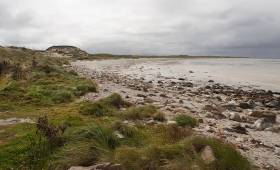
#Greystones - The Kish Lighthouse on Dublin Bay marked its 50th anniversary a year ago this November however the original caisson base destined for the iconic structure half a century ago instead became part of the now demolished old Greystones Harbour, writes Jehan Ashmore.
At the time of writing last year Afloat contacted Commissioners of Irish Lights that were celebrating five decades since the first light was cast from the then new 31 metre high lighthouse on 9 November 1965 that replaced a lightship. The authority then did not have certain information required given the timeframe involved and no direct records were readily available surrounding the details of the original caisson base. The structure in essence had been damaged during a storm in 1963 that led to a crack in the reinforced concrete caisson which was replaced by a new base and sunk on the site at the Kish Bank.
It was during April of this year, six months after the Kish Lighthouse 50th anniversary that further information emerged as to how the damaged caisson ended up in old Greystones Harbour. Such details arose following an Irish Times obituary on the passing of the late Derek Paine.The renowned boat-builder and native of the coastal Wickow town is where Paine was among key figures in the Greystones Civic Association that were instrumental in acquiring the base of the new lighthouse in 1966. The base was used to extend and protect the now demolished Victorian harbour.
Irish Lights however were able to provide a source reference to the Greystones Guide in which the aids to navigation authority believe the details outlined about the base below is accurate.
The guide's record reads: “1966 – Founded in the late 1950s, the Greystones Civic Association had among their key objectives improvements to the harbour area. An opportunity arose – the Kish lightship was to be replaced with a lighthouse. The first ‘Kish Base’ would have been the foundation for the lighthouse. Built in Dun Laoghaire Harbour and designed to be sunk onto the Kish Bank, it developed cracks after storm damage and could not be used. The G.C.A. acquired it and planned to use it as part of a breakwater to extend the pier at Greystones. After a night of drama when it broke its tow and drifted to the South Beach, it was placed off the end of the pier. However it settled further into the harbour than planned. Having now cracked open, it could not be moved. The intent had been to have it placed more in line with the existing pier. Nevertheless, for the first time, the harbour had some protection from northeasterly gales. Boulders filled the gap between the Kish Base and the old pierhead and the roadway and base were poured with concrete”.
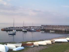
Afloat.ie adds that the former Kish Lighthouse base was providing a pierhead like structure given its apt circular shape at the old yet quaint Greystones Harbour. The current Greystones Harbour Marina features rounded pierheads at the entrance and to the inner harbour. The older smaller harbour only had moorings before been completely transformed against a backdrop of controversy.
The lighthouse completed by Swedish contractor Chriatiani Nielsen JV and Sisk as a reader commented last year would ironically become the developer of Greystones Harbour Marina all these years later. The marina opened in Easter 2013 and currently caters for boats ranging 6 to 60m in length and with capacity initially of 100 berths to increase to 230 berths.
Emergency Repairs On East Coast Rail Line After Storm Angus Erosion
#CoastalNotes - Coastal defences in Wicklow suffered significant damage during last week’s Storm Angus, posing a renewed threat to the East Coast rail line, as The Irish Times reports.
The Irish Sea came within metres of the busy Dublin-Wexford line in parts between Newcastle and Wicklow town after erosion from high tides powered by Force 10 winds in the first winter storm of the 2016-17 season.
The same extreme conditions saw a Stena Line ferry stranded outside Fishguard, unable to dock in the Welsh port for more than 24 hours after sailing from Rosslare last Tuesday morning (22 November).
Damage is said to be most severe in Co Wicklow close to where extensive repairs were carried out this past January, with rock armour placed on the adjacent beach at the Murrough, a Natura 2000-designated wetland that’s the largest of its kind on the East Coast.
Further rock armour and steel piling is now being placed at Greystones going south to Kilcoole to protect that stretch of the line after the storm displaced a significant amount of sand, as Iarnród Éireann declared “emergency intervention was required immediately” to save the rail line from future incursion by the sea.
The Irish Times has more on the story HERE.
Beached Houseboat Could Be Mayo Tourist Attraction

#Houseboat - The Canadian houseboat that washed up on the northwest Mayo coast earlier this month could be repurposed as a tourist attraction for the region.
As previously reported on Afloat.ie, the vessel drifted across the Atlantic from Newfoundland to Cross Beach on the Mullet Peninsula in a matter of weeks, some time after it was apparently donated to homeless youths by its owner Rick Small.
The local coastguard unit in Belmullet says it has so far been unsuccessful in its attempts to contact Small, in which case the vessel technically counts as a shipwreck.
And according to CBC News, it could eventually be repurposed as a tourism draw for the area, which lies on the Wild Atlantic Way.
Indeed, a local group known as the Men’s Shed has already been consulted about ideas for restoring the houseboat.
National Commemoration Service for Irish Seafarers to Be Held in Dublin, Dun Laoghaire and Cork
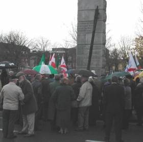
#Commemorations – The annual National Commemoration Service for Irish Seafarers in Dublin on Sunday, 20th November will notably be followed on the same day with an Ecumenical Service held in the National Maritime Museum, Dun Laoghaire. The annual service is hosted by the Maritime Institute of Ireland which this year marks a 75th anniversary.
As referred above the Service for seafarers will be held in the capital at 12:00 hours at the City Quay Memorial to Irish Seafarer's which is dedicated to those lost at sea in WW2. Also notable this year is the centenary period of WW1 in which this will add to the importance in recognising the enormity of both wars and the loss of life from Irish merchant ships. The memorial is located downriver nearby to Tara Street DART Station.
War-time Irish shipping companies ‘House Flags’ along with the banner of the Maritime Institute of Ireland will be paraded by the Sea Scouts. Wreaths will be laid at the memorial. In addition to addresses made the wreaths will be brought into Dublin Bay and floated on these waters. Traditionally this honour is performed on a rotational basis between the tugs of the Dublin Port Company, Naval Service vessels or a R.N.L.I. lifeboat.
Dun Laoghaire Ecumenical Service: Sunday 20th November
On completion of ceremonial proceedings in Dublin (as above) the company will depart that afternoon of Sunday 20th November for the National Maritime Museum of Ireland in Dun Laoghaire. At 14:00hrs an ecumenical service is to be held in the museum housed in the former Church of Ireland Mariner’s Church. The museum is located on Haigh Terrace opposite the Lexicon Library.
The service is to be conducted Fr. Pat Mernagh CF, army chaplain and Rev. William Black port chaplain. All are welcome to attend and following proceedings refreshments will be served.
Cork Ecumenical Service: Sunday 27th November
On the following weekend, the M.I.I.’s annual Cork Ecumenical Service will be held in the Port of Cork Office at 12:00 hrs, Sunday 27th November. The venue of the historic building on Custom House Street is located downriver from the nearby Cork City Bus Eireann station.
Likewise of the services held in Co. Dublin of the previous weekend, anyone who has an interest in the sea are very welcome to attend.
75th Anniversary of Maritime Institute of Ireland
The 75th anniversary of the Maritime Institute of Ireland (Foras Muiridhe na h-Eireann) was marked last month on 31st October 1941, one of the most critical moments in this country’s history.
Some of the founders and earliest supporters had been trying to impress on the general public and on government for at least the previous five years, in particular its real founder and longest serving President, Colonel Anthony Lawlor, that if, as seemed more and more inevitable, a catastrophic European war were to break out, Ireland would very quickly be in crisis. While we had very good reason to declare ourselves neutral, nobody in the highest position of critical responsibility had taken the trouble to ensure how a small neutral island which depended on the importation of vital food and other supplies was going to survive when the ships, mainly owned by non-nationals that carried our vital imports and valuable exports were no longer avail-able. Yet, by 1942, this was precisely what had happened and starvation and economic collapse were all too visible on the horizon to even the dumbest politicians.
The current role of the M.I.I. is to foster an appreciation of our maritime heritage. To that end asides hosting and supporting commemorations, they operate the maritime museum, host lectures, issue newsletters, maintain a library and promote and conduct research.
Houseboat Found On Mayo Beach Crossed Atlantic From Canada
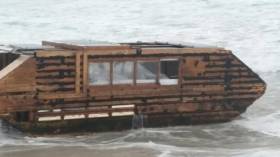
#Houseboat - Just days after reports of fatty balls on Mayo beaches comes word of a houseboat that’s washed up on the county's northwest coast after crossing the Atlantic from Canada.
RTÉ News reports that the houseboat was set to be removed today (Monday 14 November) by Mayo County Council after beaching on Cross Beach on the Mullet Peninsula at the weekend.
The vessel, which may have been docked in Newfoundland as recently as late September, was apparently donated to ‘a homeless youth’ by its owner Rick Small – who gained some celebrity in Canada two years ago for riding a solar-powered tricycle across the country.
RTÉ News has more on the story HERE.
1916 Easter Rising Maritime Themed Exhibition: Portals of Unpreparedness
#1916rising – A 1916 Easter Rising maritime themed exhibition entitled ‘Portals of Unpreparedness’ was launched today (14 November) in the Dun Laoghaire Lexicon Library.
The exhibition focuses on the arrival on the morning of 26th April 1916 of the Sherwood Foresters Regiment of the British Army in Dún Laoghaire (Kingstown in 1916). From there the regiment would march to Dublin and the Battle of Mount Street Bridge.
The exhibition by Leo Cullen and Peter Derbyshire is held on Level 5 of the Lexicon and continues to 20th December.
The main bulk of the British Army force, the non-commissioned ranks, made the Irish Sea crossing on board S.S. Tynwald and the officers on S.S. Patriotic. Also involved was the S.S. Munster as previously reported on Afloat.ie following the RTE/BBC documentary ‘The Enemy Files’ presented by former British Conservative Defence Minister Michael Portillo.
The portals, or viewpoints onto the events, as seen by a variety of witnesses include: the porthole of a troop carrier on the Bay; a window of the Royal St. George’s Yacht Club and the top of a tram.
The exhibition deploys hand drawn map images sourced from contemporary maps, paintings and sketches and commentary through poetry and prose.
Warning Over ‘Fat Balls’ On Mayo Beaches
#CoastalNotes - Dog walkers have been warned to keep their pets away from smelly, fatty globules that have washed up on the North Mayo coast in recent weeks, as The Irish Times reports.
One woman on the Mullet Peninsula says her dog became ill after eating part of one of the ball-like fatty deposits, which could be the waste products of materials used to clean up oil spills at sea — or possibly congealed palm oil used for cooking and released legally by ocean-going vessels.
The Irish Times has much more on the story HERE.
WW1 Naval Gun Goes On Display at Dun Laoghaire's Maritime Museum
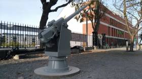
#WW1gun - A World War 1 gun retrieved from a wreck off Dalkey Island in Dublin Bay has recently gone on display at the National Maritime Museum in Dun Laoghaire, writes Jehan Ashmore.
The restored 6-pounder Hotchkiss gun is from the wreck of HMS Guide Me II. The exhibit was recently remounted in the grounds of the former Mariners Church on Haigh Terrace.
The HMS Guide Me II was built in 1907 as a Peterhead F.V. Drifter (i.e. a drift-net fishing boat) from the Scottish yard of Hall, Russell & Co in Aberdeen. In March 1915, she was hired by the Admiralty and converted into an anti-submarine coastal gunboat, with the addition of the six-pounder gun.
During a patrol she collided and depending on reports, the incident occured with an unnamed vessel or the nearby Muglins, a rocky islet east of Dalkey Island. The site of impact is clearly visible as a large hole is on the starboard side.
The Guide Me II grossed 100 tons and was approximately 26m long and 5.6m wide. The wreck lies 1.5 miles south-east of the Muglins and was rediscovered in 1990 by Ivan Tunsted who also rasied the gun from a depth of 33 metres.
For further details, they are available from INFORMAR by downloading PDF document here
In addition there’s also a 3D rendering (with a correct browser), from INFOMAR/Ulster University website click here
Major Drugs Find In ’Suspicious Item’ On Co Clare Beach
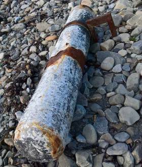
#CoastalNotes - A whopping 75kg of cocaine has been seized by the Revenue Commissioners from a torpedo-like capsule on a beach in Liscannor, Co Clare, as Independent.ie reports.
The “suspicious item” containing the drugs, thought to have a value of €5 million, is believed to have been attached below the waterline of a seagoing vessel — but it is not yet known where the drugs originated, nor their intended destination.
The drugs were found on Monday 24 October via a tip from the public through the Customs Drugs Watch Programme, which encourages coastal communities, maritime personnel and people living near airfields to report unusual or suspicious activity to Revenue via its confidential Freephone line 1800 295 295.
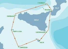
#Lecture - Glenua & Friends presents a lecture: Rolex Middle Sea Race 2015 - How Malahide Father & Son Won the Double-handed Division.
The talk by Dermot Cronin takes place next Thursday 13 October at 20:00 in Poolbeg Yacht & Boat Club Ringsend. Entry €5 (in aid of RNLI)
The Annual 608 mile Rolex Middle Sea Race is the Mediterranean equivalent of the Fastnet.
Every October it attracts a large international entry to Valetta in Malta, the starting point of the 608 mile race where skippers and crew experience a diversity of landscape and varying sea conditions defined by frustrating light airs to sail-splitting storms.
In his illustrated lecture, Dermot Cronin of Malahide Yacht Club, will bring us the inside story of how his son Paddy and himself won the Double-handed division of the 2015 Middle Sea Race in their yacht Encore, a First 40.7.
Apart from the tactical challenges, it was an energy–sapping race with frequent sail-changing and variable winds reaching 42kts+.
Ever since his first sailing course with Glenans in Bere Island in 1979, racing around islands has attracted Dermot. Being an active racing member of Malahide Yacht Club since 1989, he progressed to Round Ireland racing, D2D’s and Fastnet in 2003.
In Encore he headed for Malta where he raced the Middle Sea Race in 2013 and 2014 fully crewed. His son Paddy has won the Round Ireland Double-handed division twice along with the RORC UK equivalent. Thus father and son teamed up in October 2015 for Double-handed division of the Middle Sea Race.


 linking Spain.")


 Michael Murphy Schull Harbour Sailing Club (SHSC), Eric Coogan Heineken Ireland, Mark Murphy, Commodore SHSC, Jack Allen SHSC, Carmel O'Regan SHSC, Cornelious Ndlovu, Schull Harbour Hotel Operations Manager and Derval Murphy SHSC")


