


Displaying items by tag: Dalkey Island
Epilepsy, Lack of Lifejacket Big Factors in Death of Dublin Boatman - MCIB
#MCIB - The death by drowning of a South Dublin boatman may have been avoided had he been wearing a lifejacket or buoyancy aid, according to investigators.
The report by the Marine Casualty Investigation Board (MCIB) into the death of Aidan Fennell off Dalkey Island on 12 October 2010 found that an epileptic episode could have caused him to fall overboard from his rowboat and become disorientated once in the water.
Fennell, 43, was considered a competent boatman and a strong swimmer used to cold water, though was prone to seizures where he could not control his muscles and lost sense with reality, on occasion becoming unconscious.
On the afternoon of 12 October last year Fennell had launched his boat from Coliemore Harbour in fair conditions, intending to ferry a German family to Dalkey Island. When they pulled out of the trip, Fennell decided to row to the island on his own, with no flotation devices on board.
He was last seen by friend Kevin O'Farrell at 2.50pm. Around half an hour later, O'Farrell became concerned as to Fennell's whereabouts when he had been out of sight for some time.
After notifying the Irish Coast Guard, the Dun Laoghaire lifeboat and coastguard helicopter Rescue 116 were dispatched to search the area. Fennell's boat was located before 4pm washed on the rocks at the southeast end of Dalkey Island, and his body was found in the water close by some 10 minutes later.
No injuries were found on Fennell's body, suggesting that he went into the water before his boat washed up on the rocks.
The report concluded that if he had fallen overboard in normal conditions "it is considered likely that he could have swum to his boat, or clung on to the oars.
"However, if he had suffered an epileptic episode... he would have had great difficulty in staying afloat, in particular without having the buoyancy assistance of a life jacket."
The full report is available to download as a PDF from the MCIB website HERE.
Tanker and Lifeboats Conduct Emergency Exercises off Dalkey Island
Crew kitted in similarly bright orange coloured sea safety-survival suits entered the lifeboat before it plunged into the water. The activity was observed through the binocular-scope which overlooks Coliemore Harbour with excellent views across the sound to Dalkey Island, Dublin Bay and Howth Peninsula.
The binocular-scope does not require payment to operate and was unveiled in 2008 in memory of local resident the late Dr. John de Courcy Ireland, the 'father' of maritime Ireland (to read more click HERE). He was for 26 years a honorary secretary of the local RNLI station in Dun Laoghaire and a staunch campaigner of Irish maritime affairs.
Each Monday a routine lifeboat practice is conducted by the 47ft Trent class ALB (all-weather lifeboat) RNLB Anna Livia (info and PHOTO). Last night's drill also involved the new D-class ILB (inshore lifeboat) RNLB Réalt na Mara which was named earlier this year by Kathy Kenny, wife of RTE presenter Pat Kenny.
Under the cover of darkness the crew of the ILB Realt na Mara simulated an 'injured casualty' on the island where the casualty was prepared to be taken off by stretcher from the island's small harbour. From there the casualty was transferred to the larger RNLB Anna Livia which lay offshore. During the exercise, powerful searchlight beams from the ALB provided essential light to assist in the transfer operation.
Asides the lifeboats, there is plenty of wildlife to observe on the rocky outcrops at Maiden Rock, Clare Rock and Lamb Island, which forms the second largest island after the main island of 22-acres, where a resident herd of goats have been part of the local community for over 200 years.
As for the South Korean built Cumbrian Fisher, she too has close connections with these waters as she was named in Dublin Port in 2005. She is a frequent caller to Dublin bringing bulk liquid products from the oil refinery in Milford Haven, Pembrokeshire which is a major supplier, serving the demands of the capital.
Dublin Port has two oil jetties which cater for four tankers, where bitumen, chemicals, liquid petroleum gases, molasses and oil are handled on a 41-hectare zone with storage for 330,000 product tonnes to include 6,000 tonnes of LPG. In addition aviation fuel is frequently delivered to the terminal to satisfy the constant demand for aircraft using Dublin Airport.
Cumbrian Fisher alongside her sister Clyde Fisher where built for James Fisher & Sons and in recent years they have tended to take anchorage off Dalkey Island and off the Nose of Howth. In comparison the vast majority of vessels anchor in Dublin Bay which is divided into quadrants for the purposes of anchorage allocation.
Before the completion of the South Wall in Dublin Port, which considerably improved safer access of vessels entering the River Liffey, it was the relative deeper and sheltered waters of Dalkey Sound which were used instead as Dalkey acted as the principle port for Dublin between 14-17th centuries.
Vessels would convey cargoes which were taken to and fro by lighter to the coast where it was carried by horse and cart to nearby Dalkey before onward travel across the exposed plains to Dublin City.
To learn more about Dalkey's medieval maritime heritage with its relationship with the capital of Dublin in addition the use of Dalkey Quarry in the construction of (Kingstown) Dun Laoghaire Harbour, visit the Dalkey Castle & Heritage Centre. To read more go to www.dalkeycastle.com in addition to further information about Dalkey including the local community council newsletters click HERE.
- Dublin Bay
- Dublin Airport
- Dublin Bay News
- Commissioners of Irish Lights
- Irish Lights
- coliemore harbour
- Pembrokeshire
- Dalkey Island
- Port of Dublin
- River Liffey
- Ports and Shipping News
- The Muglins
- Coastal Notes
- Howth Peninsula
- Pat Kenny
- Dalkey Sound
- Lighthouse news
- Irish Lighthouses
- Cumbrian Fisher
- Jas Fisher & Sons
- Clyde Fisher
- Milford Haven Oil Refinery
- Dalkey Castle & Heritage Centre
- Dr. Ireland
- Dr. John de Courcy Ireland
- Irish maritime historian
- Kingstown Harbour
- Kathy Kenny
- RTE presenter Pat Kenny
- South Wall Dublin Port
- Medieval Dalkey
- Dalkey Quarry
- Aviation fuel
- Dalkey Tidy Towns Committee
- Nose of Howth
- Dublin Port Oil Jetty Terminal
- Dalkey Community Council
- Dalkey Island Goats
The 162 gross tonnes tug had served a career of nearly three decades in Dublin Port, after entering service in 1972. Prior to working in Irish waters the 100ft tug spent the previous decade operating in the UK as Appelsider for Lawson-Batey Tugs Ltd who chartered her to Tyne Tugs Ltd. For historical record and photos click HERE.
In 1998 the Dublin Port Company disposed of the Coliemore alongside her running mate Clontarf (1963/178grt) the former Cluain Tarbh, also built from the same Yorkshire shipyard on the banks of the River Humber.
Initially they were towed to Liverpool but they later appeared at Cork Dockyard in 1999. The Clontarf remained there for a year until she was sold to Barcazas Dominicia SA, Santo Domingo in the Dominican Republic. For photo of the tug in far distant waters click HERE. It was intended Coliemore would follow her Caribbean counterpart but her sale fell-through.
The vessel's ownership eventually transferred to Cork Dockyard where her scrap value will pay for her long-term berthing fees. The tug recently made her final short journey under tow from her berth at the former Verolme Cork Dockyard (VCD) to the facilities slipway where work to break-up the vessel began.
Coliemore and her fleet-mates were given the traditional naming theme of Dublin Bay coastal suburbs spelt in Irish. The naming policy was used by the Dublin Ports & Docks Board (DP&DB) which operated the fleet remained until transferred to the Dublin Port Company established in 1997.
The last tugs to carry the traditional names, Ben Eadar (Howth), Cluain Tarbh (Clontarf) and Deilginis (Dalkey) are now up laid-up awaiting to be sold, to read more click HERE.
Between the 14-16th centuries Dalkey Sound became increasingly important as larger vessels with deeper drafts could no longer enter the port in Dublin due to the dangers of constantly shifting sandbanks and swallow channels in Dublin Bay.
The nearest alternative was for vessels to anchor off Dalkey Island and in the relative shelter of Dalkey Sound where cargoes for the capital where transferred to and fro by lighters to the coastline along Dalkey at Coliemore, which became the principle port for Dublin. Some of the cargo was stored temporally in the medieval castles in Dalkey, otherwise it was directly transported by horse and cart across the plateau to the city.
It was not until the 17th century that the issue of accessing the port of Dublin was resolved, with the completion of the harbour walls that enabled shipping to return on a frequent basis. Captain Bligh of the 'Mutiny on the Bounty' completed mapping Dublin Bay in 1803 which became the most accurate chart at the time and this aided to the safety of mariners.
The fortunes of Dublin's shipping trade increased due to the combination of an easier and safer navigational channel and deeper depths along the quaysides. This led to the eventual demise of shipping using Dalkey. The present-day harbour structure at Coliemore Harbour was constructed in 1868 and is home to a humble fleet of recreational boats and a passenger-ferry service to the island.
- Howth
- Dublin Bay
- Dublin Port
- Clontarf
- Dublin Port Company
- dalkey
- coliemore harbour
- Dalkey Island
- Port of Dublin
- Ports and Shipping News
- Cork Harbour News
- Verolme Cork Dockyard
- VCD
- Dalkey Sound
- Mutiny on the Bounty
- Dublin Port Tugs
- Deilginis
- Captain Bligh
- Dublin port tugs for sale
- Coliemore
- Coliemore tug
- Cork Dockyard
- Cork Dockyard Rushbrooke
- Cluain Tarbh tug
- Ben Eadar tug
- Deilginis tug
- Richard Dunston (Hessle) Yorkshire
- River Humber
- Dublin Ports & Docks Board
- DP & DB
- Cork Dockyard shiprepairers
- Irish shipbuilding
Veolia Environnement Clocks 15 Knots on Dublin Bay
The exotic French Trimaran Veolia Environnement was in Dalkey Sound this morning. The high speed craft circled around the island in modest north westerly winds and returned into Dublin Bay for what appeared to be a helicopter publicity-photoshoot. According to vessel tracking system she got up to 14.8 knots and no doubt more!
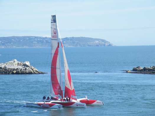
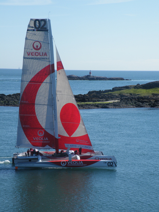
Veolia Environnement sails briskly down Dalkey Sound. Photo: Jehan Ashmore
Up Close and Personal: New Boat Tours of Dublin Port
In addition to cruising this stretch of the River Liffey alongside the 'Docklands' quarter, the tour RIB boat will pass downriver through the East-Link toll bridge where visitors will get closer views of the variety of vessels and calling cruise liners from other ports throughout the world.
There will be five daily tours beginning at 10.00am, 12.00pm, 2.00pm, 4.00pm and 6.00pm.Tickets cost €15.00 for adults, €12.50 for students and the charge for senior citizens and children is €10.00.
In addition Sea Safari operate a 'River Liffey' only tour, a Dublin Bay 'North' and 'South' tours which visit Howth Head, Baily Lighthouse, Ireland's Eye and to Dalkey Island and Killiney Bay, where both bay tours provide a chance to spot local marine wildlife of seals, porpoises and sea birds.
- Rib
- Dublin Port
- Dublin Docklands
- Howth Head
- marine wildlife
- Cruise Liners
- Sea Safari Tours
- Dalkey Island
- Port of Dublin
- River Liffey
- Ports and Shipping News
- EastLink
- EastLink Toll Bridge
- Dublin Port news
- Baily Lighthouse
- Killiney Bay
- Seabirds
- Port of Dublin news
- RIBcraft
- M.V. Cill Airne
- Dublin Port cruise liners
- North Quay Wall Dublin
- Dublin Bay tours
- Ireland's Eye
Crew Brought to Safety by Dun Laoghaire Lifeboat
The pair anchored their boat as a precaution and awaited the arrival of the lifeboat that was already at sea on a routine exercise less than two miles away.
A towline was passed to the vessel and was taken to safety and brought alongside at Dun Laoghaire.
Related Safety posts
RNLI Lifeboats in Ireland
Safety News
Rescue News from RNLI Lifeboats in Ireland
Coast Guard News from Ireland
Water Safety News from Ireland
Marine Casualty Investigation Board News
Marine Warnings
“Treasure Island” Sea-Scenes Start Shooting

Earl of Pembroke with helicopter above off The Muglins. Photo. Jehan Ashmore/ShipSNAPS
The two-part production starring Emmy award winning actor Eddie Izzard, is to play the role of iconic one-legged pirate, Long John Silver in the classic Robert Louis Stevenson 18th century tale of adventure and treasure. Also starring is Rupert Penry-Jones, best known for his spy role in the BBC TV series Spooks.
Since arrival to Dun Laoghaire in mid-November the 145-foot Earl of Pembroke has been undergoing modifications at the Carlisle Pier in preparation of the film. The barque is owned by the Cornwall based SquareSail which specialises in tall ships for film productions. The ship's silver-screen credits include Cutthroat Island, Frenchman's Creek, Hornblower Series III and Longitude.
The Treasure Island shoot involves two Dun Laoghaire based companies, Parallel Film Productions and the Irish National Sailing School (INSS) which is providing marine co-ordination services. The drama was commissioned for the Sky 1 HD TV channel and the director is Steve Barron (Arabian Nights, Merlin, England Manager).
The production follows 'Neverland' a two-part prequel to the Peter Pan story also produced by Parallel Films. Neverland was shot on the coast at Dalkey Sound, Killiney Hill in Co. Dublin and neighbouring Co. Wicklow. Both productions are part of a multi-million pound investment by Sky for their high-definition (HD) drama department.
In the New Year the Treasure Island production moves to Puerto Rico in the Caribbean. The drama is scheduled to be released in Christmas 2012.
Looking for further reading on Tall Ships in Ireland? Click the links below:
Click this link to read all our Tall Ships Stories on one handy page
Previewing Ireland's Tall Ships 2011 Season
Can Ireland Get a New Tall Ship?
Potential Oil-Field off Dalkey

"It's another evaluation process which is positive, an encouraging tick in the box. But ultimately it's only exploration-it has to be drilled", said Tony O'Reilly, CEO of Providence. "I'm hoping that'll be 2011, as part of our overall multi-basin programme in Ireland. We've a big programme of activity and the Dalkey Island (Prospect) will be part of that", he added.
The advantage of any potential oil find at the Dalkey Prospect is that the block well is in shallow waters up to 25-metres, compared to Providence deeper offshore projects of Dunquin and Spanish Point. Another factor in drilling off Dublin Bay is that operations are cheaper and safer. The naming of the exploration site after Dalkey, reflects the Kish Basin's relative geographical proximity to that particular stretch of coastline, marking the southern approaches to Dublin Port.
The optimism expressed about the Kish Bank Basin exploration and other fields must be put into context based on the previous track record of drilling around the Irish coast. The Irish Offshore Operators'Association (IOAA) has pointed out that the exploration industry has spent some €3 billion on around 130 drill-well testing sites since 1970, to little effect. The cost of a well operation off the west coast is over €50m and with such high investment, only up to two wells are carried out annually. Of the commercially viable wells, just four-fields have been exploited, but all are gas-based.
The IOAA says that there is potential but there needs to be more exploration activity. In 2009, only two bids for exploration licences were made, compared to 350 offers sought in UK waters. The association blames the lack of exploration due to delays experienced at the Corrib field, an absence of infrastructural development and expensive operating costs.
The association says the rewards are great, citing the Department of Energy's estimate of recoverable reserves of 10 billion barrels of oil. At that amount, the figure is 100 times the state's annual energy consumption of both oil and gas.


 linking Spain.")


 located at Ringsend on the south bank of Dublin Port. AFLOAT also add the Group over the last decade has invested over €30 million across MTL’s infrastructure and the terminal has a throughput of 250,000 TEU’s per year, with direct LoLo connections with ports in Central Europe and Irish Sea as well as feeder services connecting us with the Far East, India and South America.")


 Michael Murphy Schull Harbour Sailing Club (SHSC), Eric Coogan Heineken Ireland, Mark Murphy, Commodore SHSC, Jack Allen SHSC, Carmel O'Regan SHSC, Cornelious Ndlovu, Schull Harbour Hotel Operations Manager and Derval Murphy SHSC")


