Menu

Ireland's sailing, boating & maritime magazine

Displaying items by tag: Dun Laoghaire East Pier

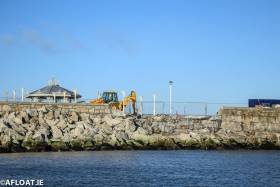
Repairs are underway to the East Pier that was damaged in March's Storm Emma. The extent of the damage is visible from this landward photograph that reveals a breach in the harbour wall close to the bandstand area.

There was 'substantial damage' to Dun Laoghaire's East Pier following Storm Emma. 

Dublin harbours bore the brunt of the easterly storm when high seas caused flooding and infrastructural damage with the damage to the country's largest man made harbour revealed in these pictures here.

The bad news for the harbour, following its bicentenary year, came as Dun Laoghaire-Rathdown County Council recommended the dissolution of Dun Laoghaire Harbour Company and the transfer of its assets to the local authority that has since been completed.

The 'soft' re-opening of the Maritime Institute of Ireland's (M.I.I.) renovated maritime museum in Dun Laoghaire is this Sunday, though the opening is dependent to fire officer's approval, writes Jehan Ashmore.
For several years the museum has been closed due to extensive renovation that was urgently required in the former Mariners Church built in 1837. In 1971 the church closed and the museum moved into the building in 1976. The church retains many of the original features, including the prisoner's docks in the gallery and magnificent stained glass windows. Externally the building has also undergone external renovation with extensive cleaning of the structure's stonework.
It is situated between the town's main shopping thoroughfare on Georges Street Upper and Dun Laoghaire Harbour's East Pier. If you are arriving to Dun Laoghaire by DART, why not take the short stroll to the museum along The 'Metals' as far as the Christ the King sculpture opposite the East Pier. From here there are steps that lead up to Haigh Terrace and the museum.

At the end of this month the M.I.I. will celebrate the 70th anniversary of its foundation and it is the intention of the voluntary run museum to 'officially' re-open in March 2012.

To read more about the renovation programme click HERE. If you would like to assist through voluntary work, fund-raising activities or make a donation in addition to keeping abreast of the latest developments visit www.mariner.ie


View Larger Map
Published in Dublin Bay
On a rare occasion both the Marine Institute's research vessels docked in both Dublin Bay ports today, normally these vessels operate mostly off the western seaboard and using their home-port of Galway Harbour, writes Jehan Ashmore.
The 65m RV Celtic Explorer (2002 /2,425grt) made an early morning call to Dublin Port's Ocean Pier. Her smaller fleet-mate RV Celtic Voyager (1996/340grt) made a midday arrival to Dun Laoghaire Harbour's East Pier. She moored at the same berth last month, as previously reported on Afloat.ie The larger vessel has a greater range capability while the smaller vessel covers more inshore-work throughout the Irish coastline.

According to the vessels survey schedules, RV Celtic Explorer had today completed fisheries demersal surveys which started in Galway on 23 September. The near fortnight-long survey was conducted in the ICES area VI, under the direction of chief scientist, Dave Stokes.

On Friday she embarks on a herring acoustic survey which is to take place in the Celtic Sea and the south-west. This survey will be under chief scientist Ciaran O'Donnell and is to de-mobilise in Cork on 27 October. To read more about her 2011 survey programme click HERE.

Across Dublin Bay in neighbouring Dun Laoghaire, the 31m RV Celtic Voyager is currently nearing the end of a month-long hydrography survey of the Celtic Sea. The survey had started in Howth Harbour on 17 September under chief scientist Kevin Sheehan. For the time-being she remains moored in Dun Laoghaire prior to resuming survey work which will continue until the vessel de-mobilises in Rosslare in mid-October. To find out more about her remaining surveys for this year click HERE.

On the surveys outlined they are conducted on behalf of Marine Institute scientists, though the vessels are also allocated ship-time for use of third parties. These include government departments and agencies, universities, research institutes and industry. For further information on the research vessels, survey schedules etc can be found by visiting: www.marine.ie/home/Research+Vessels.htm


Published in Marine Science
Tomorrow morning walkers at Dun Laoghaire Harbour's pier-heads will have close-up views of the departing Solitaire du Figaro race fleet and a French Navy patrol vessel, writes Jehan Ashmore.
At 11 o'clock the third race-leg heads for Les Sables d'Olonne, Vendée, a distance of 475 miles. They will be accompanied by the (OPV) offshore patrol vessel PSP Cormoran (P677) which is scheduled to depart in advance at 10 o'clock so to allow the boats to gather in Dublin Bay. From there the PSP Cormoran will act as an escort 'guard-ship'. A role in which she has been engaged since the prestigious solo-sailor race started a fortnight ago.

The 447 tonnes OPV provides communication liaison and assistance should the forty six sailors require during the arduous race including SAR. As such the vessel can deploy a rapid response high speed RIB-craft from an internal dock-well located at the stern.

Otherwise the RIB is used to board fishing vessels as part of fishery monitoring duties and patrolling France's Exclusive Economic Zone out to 200 nautical miles (370 km). She is a Flamant class OPV and was built in 1997 by the Cherbourg based shipyard Constructions Mécaniques de Normandie. The 54m/177-ft craft is equipped with two 12.7mm machine guns.

As Dun Laoghaire is the only international port of call during the four-leg stages of the 1,695 nautical miles (3,390kms) the hosting of the Irish harbour is a welcomed boost to the sailing community and the local economy. Leading off the Carlisle Pier are pontoons where the one-design boats are moored and opposite is the East Pier jetty berth where the PSP Cormoran is docked.

Also at the East Pier is a festival market which is part of the Festival des Bateaux. The three-day festival ends tomorrow and was organised by the race-hosts the National Yacht Club, the Dun Laoghaire Harbour Company and Dun Laoghaire Rathdown County Council. For further festival details click HERE.

The presence of a foreign naval visitor to the harbour was more commonplace particularly during festivals held in the 1980's. In addition to the French, navies from Belgium, The Netherlands were regular festival participants.

Published in Navy

About Dublin Port 

Dublin Port is Ireland’s largest and busiest port with approximately 17,000 vessel movements per year. As well as being the country’s largest port, Dublin Port has the highest rate of growth and, in the seven years to 2019, total cargo volumes grew by 36.1%.

The vision of Dublin Port Company is to have the required capacity to service the needs of its customers and the wider economy safely, efficiently and sustainably. Dublin Port will integrate with the City by enhancing the natural and built environments. The Port is being developed in line with Masterplan 2040.

Dublin Port Company is currently investing about €277 million on its Alexandra Basin Redevelopment (ABR), which is due to be complete by 2021. The redevelopment will improve the port's capacity for large ships by deepening and lengthening 3km of its 7km of berths. The ABR is part of a €1bn capital programme up to 2028, which will also include initial work on the Dublin Port’s MP2 Project - a major capital development project proposal for works within the existing port lands in the northeastern part of the port.

Dublin Port has also recently secured planning approval for the development of the next phase of its inland port near Dublin Airport. The latest stage of the inland port will include a site with the capacity to store more than 2,000 shipping containers and infrastructures such as an ESB substation, an office building and gantry crane.

Dublin Port Company recently submitted a planning application for a €320 million project that aims to provide significant additional capacity at the facility within the port in order to cope with increases in trade up to 2040. The scheme will see a new roll-on/roll-off jetty built to handle ferries of up to 240 metres in length, as well as the redevelopment of an oil berth into a deep-water container berth.

Dublin Port FAQ

Dublin was little more than a monastic settlement until the Norse invasion in the 8th and 9th centuries when they selected the Liffey Estuary as their point of entry to the country as it provided relatively easy access to the central plains of Ireland. Trading with England and Europe followed which required port facilities, so the development of Dublin Port is inextricably linked to the development of Dublin City, so it is fair to say the origins of the Port go back over one thousand years. As a result, the modern organisation Dublin Port has a long and remarkable history, dating back over 300 years from 1707.

The original Port of Dublin was situated upriver, a few miles from its current location near the modern Civic Offices at Wood Quay and close to Christchurch Cathedral. The Port remained close to that area until the new Custom House opened in the 1790s. In medieval times Dublin shipped cattle hides to Britain and the continent, and the returning ships carried wine, pottery and other goods.

510 acres. The modern Dublin Port is located either side of the River Liffey, out to its mouth. On the north side of the river, the central part (205 hectares or 510 acres) of the Port lies at the end of East Wall and North Wall, from Alexandra Quay.

Dublin Port Company is a State-owned commercial company responsible for operating and developing Dublin Port.

Dublin Port Company is a self-financing, and profitable private limited company wholly-owned by the State, whose business is to manage Dublin Port, Ireland's premier Port. Established as a corporate entity in 1997, Dublin Port Company is responsible for the management, control, operation and development of the Port.

Captain William Bligh (of Mutiny of the Bounty fame) was a visitor to Dublin in 1800, and his visit to the capital had a lasting effect on the Port. Bligh's study of the currents in Dublin Bay provided the basis for the construction of the North Wall. This undertaking led to the growth of Bull Island to its present size.

Yes. Dublin Port is the largest freight and passenger port in Ireland. It handles almost 50% of all trade in the Republic of Ireland.

All cargo handling activities being carried out by private sector companies operating in intensely competitive markets within the Port. Dublin Port Company provides world-class facilities, services, accommodation and lands in the harbour for ships, goods and passengers.

Eamonn O'Reilly is the Dublin Port Chief Executive.

Capt. Michael McKenna is the Dublin Port Harbour Master

In 2019, 1,949,229 people came through the Port.

In 2019, there were 158 cruise liner visits.

In 2019, 9.4 million gross tonnes of exports were handled by Dublin Port.

In 2019, there were 7,898 ship arrivals.

In 2019, there was a gross tonnage of 38.1 million.

In 2019, there were 559,506 tourist vehicles.

There were 98,897 lorries in 2019

Boats can navigate the River Liffey into Dublin by using the navigational guidelines. Find the guidelines on this page here.

VHF channel 12. Commercial vessels using Dublin Port or Dun Laoghaire Port typically have a qualified pilot or certified master with proven local knowledge on board. They "listen out" on VHF channel 12 when in Dublin Port's jurisdiction.

A Dublin Bay webcam showing the south of the Bay at Dun Laoghaire and a distant view of Dublin Port Shipping is here
Dublin Port is creating a distributed museum on its lands in Dublin City.
 A Liffey Tolka Project cycle and pedestrian way is the key to link the elements of this distributed museum together.  The distributed museum starts at the Diving Bell and, over the course of 6.3km, will give Dubliners a real sense of the City, the Port and the Bay.  For visitors, it will be a unique eye-opening stroll and vista through and alongside one of Europe’s busiest ports:  Diving Bell along Sir John Rogerson’s Quay over the Samuel Beckett Bridge, past the Scherzer Bridge and down the North Wall Quay campshire to Berth 18 - 1.2 km.   Liffey Tolka Project - Tree-lined pedestrian and cycle route between the River Liffey and the Tolka Estuary - 1.4 km with a 300-metre spur along Alexandra Road to The Pumphouse (to be completed by Q1 2021) and another 200 metres to The Flour Mill.   Tolka Estuary Greenway - Construction of Phase 1 (1.9 km) starts in December 2020 and will be completed by Spring 2022.  Phase 2 (1.3 km) will be delivered within the following five years.  The Pumphouse is a heritage zone being created as part of the Alexandra Basin Redevelopment Project.  The first phase of 1.6 acres will be completed in early 2021 and will include historical port equipment and buildings and a large open space for exhibitions and performances.  It will be expanded in a subsequent phase to incorporate the Victorian Graving Dock No. 1 which will be excavated and revealed. 
 The largest component of the distributed museum will be The Flour Mill.  This involves the redevelopment of the former Odlums Flour Mill on Alexandra Road based on a masterplan completed by Grafton Architects to provide a mix of port operational uses, a National Maritime Archive, two 300 seat performance venues, working and studio spaces for artists and exhibition spaces.   The Flour Mill will be developed in stages over the remaining twenty years of Masterplan 2040 alongside major port infrastructure projects.

Source: Dublin Port Company ©Afloat 2020.