


Displaying items by tag: Galway Bay
Possible 'Underground' Solution To Aran Islands Water Shortage
#AranIslands - 'Water, water everywhere, nor any drop to drink' has never been more true for residents of the Aran Islands who are facing their worst ever water shortage.
Now BreakingNews.ie reports on a call on Irish Water to tap into the newly discovered network of underground rivers believed to run beneath the islands and throughout Galway Bay to provide a lifeline for Aran's communities.
Tiernan Henry from NUI Galway's Earth and Ocean Sciences department says geological surveys for the freshwater aquifier systems believed to extend throughout the bay could lead to an invaluable source of fresh water for people on Inis Mean and Inis Oirr in particular, who have been forced to use water brought in from the mainland at great expense – around €1 per litre.
BreakingNews.ie has much more on the story HERE.
Galway Lifeboat Rescues Three From Vessel Adrift Off Barna
#RNLI - Galway RNLI came to the rescue of two men and a child whose boat got into difficulty off Barna Pier in Galway Bay yesterday afternoon (Friday 22 August).
The 18ft bayliner was about half a mile off Barna when its engine failed. The boat drifted for some 30 minutes before the men on board called 999, at about 2.20pm.
The Irish Coast Guard sought the assistance of the Galway lifeboat, which launched from the city docks 10 minutes later.
The lifeboat crew of helm Kieran Tolan, David Badger, Olivia Bryne and Dara Oliver quickly arrived on scene and took the vessel in tow back to Barna. None of the people on board required medical attention.
Speaking after the callout, Tolan said: "Conditions were calm, with an offshore breeze, and although at the time they were in no immediate danger, they did the right thing in calling the lifeboat as situations on the water can change very quickly into more serious incidents."
New Evidence Suggests Galway Bay Only 3,700 Years Old

#GalwayBay - Carbon dating on a fragment of an ancient oak trackway on the northern shore of Galway Bay suggests a much more recent beginning for the bay as we know it.
According to The Irish Times, the radiocarbon dating analysis pinpoints the oak sample to around 1,700 BC, which means the sea level in the region was still rising as early as 3,700 years ago – nearly 4,000 years after submerging the 'drowned forests' discovered west of Spiddal earlier this year.
A full survey of the site will be undertaken by the National Museum of Ireland but it's already believed that the trackway or platform, which may have been ceremonial in nature, was built upon what was then freshwater bogland before the rising sea waters encroached.
The Irish Times has more on the story HERE.
Funding For New Research On Galway Coastal Climate
#MarineScience - Research funding of some €96,000 has been awarded to NUI Galway to study the marine environment of Galway Bay - and what that information can mean for those who live around it.
As the Galway Advertiser reported earlier this month, the funding has been awarded through the Enterprise Partnership Scheme for a marine science project that will involve researchers from both NUI Galway and DCU in tandem with the SmartBay Ireland initiative, collecting data that could help in more accurate weather and climate modelling.
That kind of information could prove crucial to a city that bore the brunt of this year's winter storms and experienced unprecedented levels of flooding, particularly in the economically important areas of Salthill and the Spanish Arch.
The Galway Advertiser has more on the story HERE.
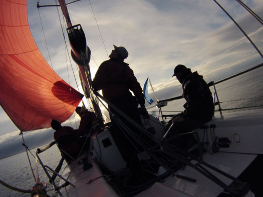
Galway Bay Club Hosts Disabled Sailing Championships
#gbsc – Galway Bay Sailing Club, for the first time in it's history, is very proudly hosting an "All Ireland" sailing event for sailors with a disability writes Lorraine Scully This national event will bring together the largest collection of disabled sailors ever assembled in Galway for a great weekend of competitive sailing. GBSC have 17 boats entered from Cork, Dublin, Belfast and Galway with 19 competitors.
The All Ireland HANSA 303 Nationals is in it's third year. 2014 in Galway will be the first time in Irish Sailing history that both juniors and adults with a disability will compete in various races over Saturday and Sunday 19th and 20th July.
Dave Vinnel, GBSC commodore, is very excited to bring these Nationals to Galway – while the club has experience of running many national sailing events this is the first time we will do so for disabled sailors. With the help of our very generous sponsors and a strong band of volunteers we are all really looking forward to welcoming sailors from all over Ireland, North and South.
Due to its stability the Hansa 303 is ideal for disabled sailors. Sailing is one of the very few activities for people with a disability that achieves parity with able bodied peers on the water. The thrill, excitement and freedom experienced by all sailors becomes universal.
For the past number of years GBSC has had growing participation from junior sailors with a disability working closely with Galway Speeders the Galway based multi-sport club for children with a physical disability whose aim is to promote sport for young people with a physical disability. GBSC now has 7 boats for use by sailors with disability and demand still out strips supply!
Just this week wheelchair users will also find the GBSC boat yard more accessible thanks to very generous sponsorship from Cold Chon Ltd who tarred a large section of the dingy park making it more accessible and wheelchair friendly.
Racing will take place from 1-4pm on Saturday and 11.30-2:30 on Sunday and all are welcome to come and visit.
Registration from 9.30 Saturday 19th for competitors
Club house open to all visitors all weekend
For more information phone Bridgette Brew 086 335 9962.
Farmer Rescues Stranded Dolphin Calf In Galway Bay
#MarineWildlife - A juvenile dolphin was saved after stranding in the shallows at Maree on Galway Bay thanks to the swift actions of a local farmer.
As the Galway Advertiser reports, Martin Costello waded out into the inlet at Ballinacourty - a notorious spot for marine wildlife strandings - to pick up the young cetacean and carry it out to deeper water, from where it was able to swim out to safety.
Such human intervention was invaluable in the rescue of an ailing seal pup that was found alone on a beach in Connemara at the weekend.
According to the Irish Mirror, the infant seal was taken to Seal Rescue Ireland in Athlone, where staff have named him Sea Noodle and are nursing him back to health, though a serious chest infection means he's not out of the woods yet.
More Research Needed On Galway Bay's Underground Rivers

#GalwayBay - Further research is needed to find out the full extent of the newly discovered underground rivers beneath Galway Bay that have surprised scientists since the discovery was announced a month ago.
Mail Online reported on researchers' claims that the sea bed off Galway could be hiding one of the world's largest networks of freshwater aquifers running between the limestone plains of the Burren and the Aran Islands.
The discovery was only made after locals on Inis Meáin talked of a freshwater well that never went dry - and an investigation by NUI Galway researchers estimated that its source must be on the mainland.
Now geologists think the discovery could be just a fraction of a vast network of underground caverns and waterways, according to The Irish Times.
And the find could prove to be a solution to the problem of chronic water shortages on nearby Inis Oírr, if the aquifers can be tapped for fresh water.
The Commissioners of Irish Lights (CIL) have unveiled a new light emitting diode (LED) light at Inisheer lighthouse on Wednesday 21st May 2014. Inisheer Lighthouse is a highly important Aid to Navigation (AtoN). This AtoN safeguards the considerable traffic between Inisheer and Co. Clare. It also marks the south-eastern end of the Aran Islands and the western side of the southern approach route to Galway Bay.
This project will provide reliable and low maintenance operational needs for Inisheer lighthouse for the next 20 years while achieving an annual reduction in operation costs for CIL of approximately 16%. The exhibition of the new light marks a significant milestone within the major Capital Refurbishment Project currently being carried out at the lighthouse.
The tower of Inisheer is 34 meters in height. This is to ensure visibility of the light due to the low lying nature of the Island. A red sector of the light delineates the potential danger of Finnis Rock lying the East. The project includes replacing the optic lamp with a new flashing LED light source in the existing lens. The light range is now reduced from 20White, 16Red to 18White, 11Red but will keep the same flashing character. The rotating mirror located in the tower has been removed and preserved for heritage purposes. A 6kW Standby Diesel Generator which previously provided power in the event of a mains outage has been removed and standby power is now provided by duplicated 24V batteries and chargers of total capacity to provide 6 days operation. The Radar Beacon (RACON) has also been replaced.
The removal of the Standby Generator will reduce maintenance requirements at the station as well as the need for fuel delivery. The installation of the LED light-source also removes the need to change lamps and reduces the number of visits by the Attendant to the station. Power requirements to the station have also been reduced resulting in lower electricity costs. The installation of an Automatic Identification System (AIS) unit for monitoring eliminates communications costs.
With the help of modern technology, CIL consistently delivers a low-maintenance, low-energy and carbon-emission reducing Aids to Navigation service around the Coast of Ireland.
#MarineNotice - Following from this weekend's survey in Donegal Bay, INFOMAR will undertake a hydrographic and geophysical survey off the West Coast in the Galway Bay area between 25 May and 7 June 2014.
The RV Celtic Voyager (Call sign EIQN) is expected to carry out the survey operations, which follow up on a previous survey completed in February.
The vessel will be towing a magnetometer sensor with a single cable of up to 100m in length.
She will also be displaying appropriate lights and markers, and will be listening on VHF Channel 16 throughout the project.
Details of the survey area are included in Marine Notice No 32 of 2014, a PDF of which is available to read or download HERE.

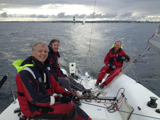
#gbsc – The final race of the GlenncahillCars.com April Series concluded last Wednesday with the final race a 'non-discard' to ensure it would all be up for grabs on the night. Eight boats were on the water to contest this first series of the year in a combined class at the Galway club and the weather delivered perfect racing conditions over five Wednesday evenings.
Liam Burke's Corby 25 'Tribal' came to the last race with a 2 point advantage over Glenn Cahill's 'Joie de Vie' but the J109 crew were clearly up for the challenge. They started well mid-line but an early cross with Martin Breen's Reflex 38 'Lynx', who returned on port from the obstruction of the South shore, leading to a strong verbal exchange. But the protest flags remained folded. This was Lynx's first evening race and her young crew performed admirably.
'Tribal' were caught in dirty air from 'Ibaraki', the GK34 formerly known as 'Joggernaut' with John Collins on the helm, forcing them to tack away as Rob Allen's Corby 25 'Smile' crossed ahead.
Approaching Cockle rock, a slight left shift favoured the leaders on that side and they hoisted to extend the lead on the run down to Oranmore mark.Barry Heskin's Dubois 32 'Now What' opted for the gybe set with Jim Grealish calling tactics. On the beat to Mutton Island the wind gusted to 18 kts and, as positions became established, boats focused on speed as it would all come down to corrected time.
Joie de Vie sailed nigh on the perfect race but ultimately it wasn't enough as Tribal took second place, enough to secure the series.
Racing continues at GBSC with the Western Surveyor Summer Series with a split in the classes as more boats come on the water. The White Sail Fleet also have their first outing.


 located at Ringsend on the south bank of Dublin Port. AFLOAT also add the Group over the last decade has invested over €30 million across MTL’s infrastructure and the terminal has a throughput of 250,000 TEU’s per year, with direct LoLo connections with ports in Central Europe and Irish Sea as well as feeder services connecting us with the Far East, India and South America.")


 Michael Murphy Schull Harbour Sailing Club (SHSC), Eric Coogan Heineken Ireland, Mark Murphy, Commodore SHSC, Jack Allen SHSC, Carmel O'Regan SHSC, Cornelious Ndlovu, Schull Harbour Hotel Operations Manager and Derval Murphy SHSC")


