Menu

Ireland's sailing, boating & maritime magazine

Displaying items by tag: Geological Survey of Ireland

Mapping Ireland’s seabed, how scientists predict flooding and how to grow your own volcano are themes of an open day hosted by the Geological Survey of Ireland (GSI) and National Museum of Ireland this weekend.

The free “Down to Earth” open day event takes place on Saturday next, May 7th, at the National Museum of Ireland - Decorative Arts and History, Collins Barracks, Dublin.

GSI scientists will be on hand to “bring land and seabed mapping to life, to show the importance of groundwater, and reveal the secrets of Irish fossils,” the organisers state.

They will be joined by colleagues from DIAS (Dublin Institute for Advanced Studies), iCRAG (the Science Foundation Ireland research centre in applied sciences), Met Éireann, and Teagasc to answer questions on earthquakes, the metals we need for life, weather and flooding, and soil.

Members of the public are invited to “try and stump the geologist” by bringing a favourite rock or fossil to have it identified by a geology curator from the National Museum of Ireland.

Sustainable arts experts ReCreate will be running workshops for those families who would like to design some geology inspired art.

The open day takes its inspiration from “Down to Earth- Exploring Ireland’s Geology”, which is currently on exhibition.

Booking is not required, and members of the public can drop in to Collins Barracks, Dublin from 11 am on Saturday, May 7th.

Published in Marine Science

#RESEARCH VESSEL CHARTER - The Geological Survey of Ireland (GSI) have chartered the Cosantoir Bradan from the Central Fisheries Board

The fisheries patrol cutter is to be used in conjunction with the RV Keary for survey work, including bottom survey of all coastal regions around Ireland.

The 15m catamaran inshore research vessel is currently undergoing modifications and refurbishing works at Arklow Marine Services yard.

Published in Marine Science
Amongst the festival tallships lining Waterford quays, the RV Keary, a marine research survey vessel that mapped the estuary in advance of the tall ships arrival, will too be open to the public, writes Jehan Ashmore.
Work to map the navigational channel of Waterford Harbour's estuary was completed last month by the catamaran hulled craft that belongs to the Geological Survey of Ireland (GSI). Her smaller fleetmate the 7.5m RIB RV Geo carried-out work in the shallower areas along the river banks. For images of the seabed survey click HERE. The survey which had started in April was a joint research programme between (GSI) and the Marine Institute (MI).

This was the RV Keary's first INFOMAR survey leg of 2011 and it was also the first time that both vessels have worked in tandem. The mapping of the estuary was from an area just west of the city's Rice Bridge to the open sea at the mouth of Waterford Harbour.

The estuary was mapped before in 2007 using the Marine Institutes larger vessel the RV Celtic Voyager, which covered the harbour approaches from the 10m contour to greater depth offshore. Both RV Keary and RV Geo overlapped their coverage with this previous data, producing a comprehensive and seamless seabed map of the area.

RV Keary is constructed of marine grade aluminium and was custom built in 2008 for the (GSI) by Veecraft Marine of Capetown, South Africa.
The 15m craft with a draft of just 2m is equipped with an extensive range of highly sophisticated technology. She has an open working area at the aft-deck to conduct operations and is licensed to carry up to 12 personnel. For further vessel characteristics click HERE.

The 34-tonne craft made her 7,000 mile delivery voyage from the African continent to Europe. She was firstly transported on the deck of a cargoship to Rotterdam. After unloading at the Dutch port the 22-knot capable craft set off with several calls along the UK south coast to include loading bunkers before finally reaching Dun Laoghaire, from where she entered service in April 2009.

Published in Marine Science

Two mussel dredger-trawlers made a rare transit of Dalkey Sound, last Friday, writes Jehan Ashmore.

The sound which is located to the south of Dublin Bay is not used by commercial traffic but is frequented by pleasure-craft, local fishing boats from Dun Laoghaire. In addition to occasional traffic by the Irish Naval Service, Marine Institute research vessel RV Celtic Voyager, the GSI's RV Keary and foreign tall-ships.
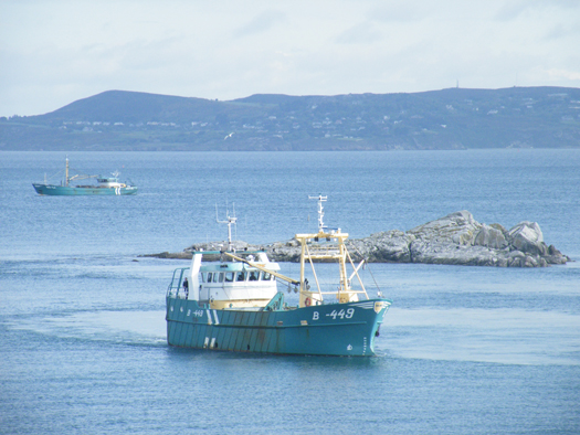
Leading the pair of mussel dredgers was the Belfast registered Mytilus (B-449) named after the mussel species 'Mytilus edulis' and the Wexford registered Branding (WD-4A).
MUSSEL_DREDGERS
Mytilus in Dalkey Sound and in the backround Branding approaches from
Dublin Bay. Photo Jehan Ashmore/ShipSNAPS

The vessels were making a southerly direction as they headed across Dublin Bay towards Dalkey Island. Mytilus lowered a mussel cage bucket into the sound which was dragged on two separate occasions over a short distance running parallel between the island and the coast.

The operation was all too brief as the Mytilus then proceeded into Killiney Bay followed closely astern by Branding. Upon entering the neighbouring bay, both vessels conducted dredging activity before continuing south beyond Bray Head.

Mussel grounds are located throughout certain hotspots in the Irish Sea and earlier this month, it is reported that there was a notable increase in mussel dredgers in Bangor, Northern Ireland. The dredgers were the Mytilus and Branding which berthed at the Co. Down harbour after a lengthy period of relative inactivity.

Mytilus was built in The Netherlands by Scheepwerf Van Os Yerseke B.V. and appeared in an episode of the successful BBC TV series 'Coast'. At the time of the broadcast she was registered at Beaumaris, Anglesey and was seen working in the northern approaches of the Menai Straits. The fishery grounds are ideally suited for the growing processes required in farmed mussel production.

Branding was also built by a Dutch shipyard, Kooieman in 1988 and her design is typical of the mussel dredgers based in Wexford. The market for mussels is mainly from the northern European countries of Belgium, France and the Netherlands.

Published in Fishing
The Co. Wicklow based Maritime Management has been awarded the ISO 9001 and ISO 14001 accreditation by the international accreditation body Germanischer Lloyd. The award to Maritime Management marks the company as a unique provider of ship management services based
in Ireland.
"These awards show our dedication to delivering high quality ship management services, beyond the strict compliance required in this highly regulated industry," said Jan Berg, managing director of Maritime Management.

"Achieving ISO 14001 accreditation, an internationally recognised green standard, shows our respect of the sensitive marine environment and has been well received by our international and Irish clients. It is of particular significance to our clients involved in underwater exploration and scientific research and those involved in the transport of agricultural produce either refrigerated or in bulk."

Maritime Management has an international client base with a diverse range of vessels. Services include technical, operational and crewing for specialist passenger ships, cargoships, refrigerated cargo ships and specialist vessels such as the exploration vessel EV Nautilus.

The vessel is managed on behalf of the famous undersea explorer Dr. Robert Ballard, who is known best for his discovery of the Titanic, PT 109 and the Bismark. Over the last two years Maritime Management has carried out major work to adapt the vessel to suit the requirements of broadcasters National Geographic and CBS.

The work carried outon the vessel has the ground breaking ability to broadcast live HD video from the ocean floor. This enabled scientific teams from the USA and around the world to interact in real time with the underwater operations. To read more about the work of the EV Nautilus and the mapping of underwater volcanoes, life forms,shipwrecks and more click here.

Maritime Management's projects in Ireland have included the design and construction of the Geological Survey of Ireland (GSI) RV Keary, a small yet high-tech survey vessel which was built in South Africa. The 15m asymmetrical catamaran is constructed of aluminium and has a speed of 15 knots. The craft has a Marine Survey Office P5 license for 12 passengers. For further technical details click here.

Published in Ports & Shipping

About Dublin Port 

Dublin Port is Ireland’s largest and busiest port with approximately 17,000 vessel movements per year. As well as being the country’s largest port, Dublin Port has the highest rate of growth and, in the seven years to 2019, total cargo volumes grew by 36.1%.

The vision of Dublin Port Company is to have the required capacity to service the needs of its customers and the wider economy safely, efficiently and sustainably. Dublin Port will integrate with the City by enhancing the natural and built environments. The Port is being developed in line with Masterplan 2040.

Dublin Port Company is currently investing about €277 million on its Alexandra Basin Redevelopment (ABR), which is due to be complete by 2021. The redevelopment will improve the port's capacity for large ships by deepening and lengthening 3km of its 7km of berths. The ABR is part of a €1bn capital programme up to 2028, which will also include initial work on the Dublin Port’s MP2 Project - a major capital development project proposal for works within the existing port lands in the northeastern part of the port.

Dublin Port has also recently secured planning approval for the development of the next phase of its inland port near Dublin Airport. The latest stage of the inland port will include a site with the capacity to store more than 2,000 shipping containers and infrastructures such as an ESB substation, an office building and gantry crane.

Dublin Port Company recently submitted a planning application for a €320 million project that aims to provide significant additional capacity at the facility within the port in order to cope with increases in trade up to 2040. The scheme will see a new roll-on/roll-off jetty built to handle ferries of up to 240 metres in length, as well as the redevelopment of an oil berth into a deep-water container berth.

Dublin Port FAQ

Dublin was little more than a monastic settlement until the Norse invasion in the 8th and 9th centuries when they selected the Liffey Estuary as their point of entry to the country as it provided relatively easy access to the central plains of Ireland. Trading with England and Europe followed which required port facilities, so the development of Dublin Port is inextricably linked to the development of Dublin City, so it is fair to say the origins of the Port go back over one thousand years. As a result, the modern organisation Dublin Port has a long and remarkable history, dating back over 300 years from 1707.

The original Port of Dublin was situated upriver, a few miles from its current location near the modern Civic Offices at Wood Quay and close to Christchurch Cathedral. The Port remained close to that area until the new Custom House opened in the 1790s. In medieval times Dublin shipped cattle hides to Britain and the continent, and the returning ships carried wine, pottery and other goods.

510 acres. The modern Dublin Port is located either side of the River Liffey, out to its mouth. On the north side of the river, the central part (205 hectares or 510 acres) of the Port lies at the end of East Wall and North Wall, from Alexandra Quay.

Dublin Port Company is a State-owned commercial company responsible for operating and developing Dublin Port.

Dublin Port Company is a self-financing, and profitable private limited company wholly-owned by the State, whose business is to manage Dublin Port, Ireland's premier Port. Established as a corporate entity in 1997, Dublin Port Company is responsible for the management, control, operation and development of the Port.

Captain William Bligh (of Mutiny of the Bounty fame) was a visitor to Dublin in 1800, and his visit to the capital had a lasting effect on the Port. Bligh's study of the currents in Dublin Bay provided the basis for the construction of the North Wall. This undertaking led to the growth of Bull Island to its present size.

Yes. Dublin Port is the largest freight and passenger port in Ireland. It handles almost 50% of all trade in the Republic of Ireland.

All cargo handling activities being carried out by private sector companies operating in intensely competitive markets within the Port. Dublin Port Company provides world-class facilities, services, accommodation and lands in the harbour for ships, goods and passengers.

Eamonn O'Reilly is the Dublin Port Chief Executive.

Capt. Michael McKenna is the Dublin Port Harbour Master

In 2019, 1,949,229 people came through the Port.

In 2019, there were 158 cruise liner visits.

In 2019, 9.4 million gross tonnes of exports were handled by Dublin Port.

In 2019, there were 7,898 ship arrivals.

In 2019, there was a gross tonnage of 38.1 million.

In 2019, there were 559,506 tourist vehicles.

There were 98,897 lorries in 2019

Boats can navigate the River Liffey into Dublin by using the navigational guidelines. Find the guidelines on this page here.

VHF channel 12. Commercial vessels using Dublin Port or Dun Laoghaire Port typically have a qualified pilot or certified master with proven local knowledge on board. They "listen out" on VHF channel 12 when in Dublin Port's jurisdiction.

A Dublin Bay webcam showing the south of the Bay at Dun Laoghaire and a distant view of Dublin Port Shipping is here
Dublin Port is creating a distributed museum on its lands in Dublin City.
 A Liffey Tolka Project cycle and pedestrian way is the key to link the elements of this distributed museum together.  The distributed museum starts at the Diving Bell and, over the course of 6.3km, will give Dubliners a real sense of the City, the Port and the Bay.  For visitors, it will be a unique eye-opening stroll and vista through and alongside one of Europe’s busiest ports:  Diving Bell along Sir John Rogerson’s Quay over the Samuel Beckett Bridge, past the Scherzer Bridge and down the North Wall Quay campshire to Berth 18 - 1.2 km.   Liffey Tolka Project - Tree-lined pedestrian and cycle route between the River Liffey and the Tolka Estuary - 1.4 km with a 300-metre spur along Alexandra Road to The Pumphouse (to be completed by Q1 2021) and another 200 metres to The Flour Mill.   Tolka Estuary Greenway - Construction of Phase 1 (1.9 km) starts in December 2020 and will be completed by Spring 2022.  Phase 2 (1.3 km) will be delivered within the following five years.  The Pumphouse is a heritage zone being created as part of the Alexandra Basin Redevelopment Project.  The first phase of 1.6 acres will be completed in early 2021 and will include historical port equipment and buildings and a large open space for exhibitions and performances.  It will be expanded in a subsequent phase to incorporate the Victorian Graving Dock No. 1 which will be excavated and revealed. 
 The largest component of the distributed museum will be The Flour Mill.  This involves the redevelopment of the former Odlums Flour Mill on Alexandra Road based on a masterplan completed by Grafton Architects to provide a mix of port operational uses, a National Maritime Archive, two 300 seat performance venues, working and studio spaces for artists and exhibition spaces.   The Flour Mill will be developed in stages over the remaining twenty years of Masterplan 2040 alongside major port infrastructure projects.

Source: Dublin Port Company ©Afloat 2020.